Stay organized with collections
Save and categorize content based on your preferences.
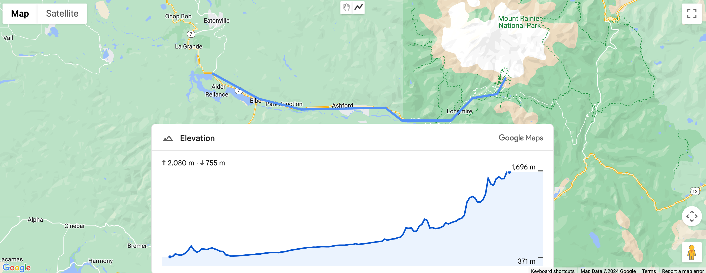
Elevation Standalone Element
The ElevationElement is an HTML element that visually displays elevation data for a single point or a polyline. It shows a graph of elevation along the path set in the path property with an array of latitude and longitude coordinates. Line segments are interpolated between the points of the array, so even a small number of points will still produce a detailed elevation graph.
Set path elevation using coordinates
The following example renders the elevation of a path between two points selected by a set of coordinates, using a gmp-elevation element.
The element is configured for metric measurement using the unit-system attribute:
A querySelector is used to select the elevation element and set its path property with latitude and longitude coordinates:
/** Maps JS loaded callback */asyncfunctioninit(){// Load the Elevation Element from Maps JSconst{ElevationElement}=awaitgoogle.maps.importLibrary('elevation');// Specify an elevation path to renderconstelevationElement=document.querySelector('gmp-elevation');elevationElement.path=[{lat:37.4523,lng:-122.2645},{lat:37.377,lng:-122.4078},];}
See the complete code example
JavaScript
/** Maps JS loaded callback */asyncfunctioninit(){// Load the Elevation Element from Maps JSconst{ElevationElement}=awaitgoogle.maps.importLibrary('elevation');// Specify an elevation path to renderconstelevationElement=document.querySelector('gmp-elevation');elevationElement.path=[{lat:37.4523,lng:-122.2645},{lat:37.377,lng:-122.4078},];}init();
<!DOCTYPE html>
<html>
  <head>
    <title>Simple Elevation</title>
    <meta charset="utf-8">
    <link rel="stylesheet" type="text/css" href="style.css">
  </head>
  <body>
    <h1>Path elevation</h1>
        <div class="overlay">
          <gmp-elevation unit-system="metric"></gmp-elevation>
        </div>
    <script>
      (g=>{var h,a,k,p="The Google Maps JavaScript API",c="google",l="importLibrary",q="__ib__",m=document,b=window;b=b[c]||(b[c]={});var d=b.maps||(b.maps={}),r=new Set,e=new URLSearchParams,u=()=>h||(h=new Promise(async(f,n)=>{await (a=m.createElement("script"));e.set("libraries",[...r]+"");for(k in g)e.set(k.replace(/[A-Z]/g,t=>"_"+t[0].toLowerCase()),g[k]);e.set("callback",c+".maps."+q);a.src=`https://maps.${c}apis.com/maps/api/js?`+e;d[q]=f;a.onerror=()=>h=n(Error(p+" could not load."));a.nonce=m.querySelector("script[nonce]")?.nonce||"";m.head.append(a)}));d[l]?console.warn(p+" only loads once. Ignoring:",g):d[l]=(f,...n)=>r.add(f)&&u().then(()=>d[l](f,...n))})({
        key: "YOUR_API_KEY",
        v: "alpha"
      });
    </script>
  </body>
</html>
Set path elevation using a polyline
The following example renders the elevation of a path based on a user-drawn polyline. It obtains the path from the user's polyline using polyline.getPath().getArray():
elevationElem.path=polyline.getPath().getArray();
See the complete code example
JavaScript
constmap=document.querySelector('gmp-map');constelevationElem=document.querySelector('gmp-elevation');asyncfunctioninit(){awaitgoogle.maps.importLibrary('places');awaitgoogle.maps.importLibrary('marker');awaitgoogle.maps.importLibrary('elevation');map.innerMap.setOptions({'mapTypeControl':true,'clickableIcons':false});findCurrentLocation();drawPolyline();}asyncfunctiondrawPolyline(){const{DrawingManager}=awaitgoogle.maps.importLibrary('drawing');constdrawingManager=newDrawingManager({drawingMode:google.maps.drawing.OverlayType.POLYLINE,drawingControl:true,drawingControlOptions:{position:google.maps.ControlPosition.TOP_CENTER,drawingModes:[google.maps.drawing.OverlayType.POLYLINE]},polylineOptions:{geodesic:true,strokeColor:'#5491f5',strokeWeight:6}});drawingManager.setMap(map.innerMap);drawingManager.addListener('polylinecomplete',(polyline)=>{console.log('complete');console.log(polyline.getPath().getArray());elevationElem.path=polyline.getPath().getArray();polyline.addListener('click',(e)=>{console.log(e);});});}asyncfunctionfindCurrentLocation(){const{LatLng}=awaitgoogle.maps.importLibrary('core');if(navigator.geolocation){navigator.geolocation.getCurrentPosition((position)=>{constpos=newLatLng(position.coords.latitude,position.coords.longitude);map.innerMap.panTo(pos);map.innerMap.setZoom(16);},()=>{console.log('The Geolocation service failed.');map.innerMap.setZoom(16);},);}else{console.log(`Your browser doesn't support geolocation`);map.innerMap.setZoom(16);}}init();
[null,null,["Last updated 2025-08-28 UTC."],[[["\u003cp\u003eThe \u003ccode\u003eElevationElement\u003c/code\u003e displays elevation data for a point or polyline on a map using a graph.\u003c/p\u003e\n"],["\u003cp\u003eYou can set the elevation path using latitude and longitude coordinates or with a user-drawn polyline.\u003c/p\u003e\n"],["\u003cp\u003eThe elevation graph is generated by interpolating line segments between the provided coordinates.\u003c/p\u003e\n"],["\u003cp\u003eThis feature is currently experimental and might have limited support.\u003c/p\u003e\n"]]],["The `ElevationElement` visually displays elevation data for a point or polyline. It uses a `gmp-elevation` element configured for metric measurements. Elevation paths can be set via coordinates or a user-drawn polyline. When using coordinates, a `querySelector` selects the element, and the `path` property is set with latitude/longitude arrays. For polylines, the element's `path` is populated using `polyline.getPath().getArray()`, to get an array of the polyline's coordinates. This feature is currently in an experimental pre-GA stage.\n"],null,["| This product or feature is Experimental (pre-GA). Pre-GA products and features might have limited support, and changes to pre-GA products and features might not be compatible with other pre-GA versions. Pre-GA Offerings are covered by the [Google\n| Maps Platform Service Specific Terms](https://cloud.google.com/maps-platform/terms/maps-service-terms). For more information, see the [launch stage descriptions](/maps/launch-stages).\nElevation Standalone Element\n\nThe [`ElevationElement`](/maps/documentation/javascript/reference/elevation-widget#ElevationElement) is an HTML element that visually displays elevation data for a single point or a polyline. It shows a graph of elevation along the path set in the [`path`](/maps/documentation/javascript/reference/elevation-widget#ElevationElement.path) property with an array of latitude and longitude coordinates. Line segments are interpolated between the points of the array, so even a small number of points will still produce a detailed elevation graph.\n\nSet path elevation using coordinates\n\nThe following example renders the elevation of a path between two points selected by a set of coordinates, using a `gmp-elevation` element.\n\nThe element is configured for metric measurement using the [`unit-system`](/maps/documentation/javascript/reference/elevation-widget#ElevationElement.unitSystem) attribute: \n\n```html\n \u003cgmp-elevation unit-system=\"metric\"\u003e\u003c/gmp-elevation\u003e\n```\n\nA `querySelector` is used to select the elevation element and set its `path` property with latitude and longitude coordinates: \n\n```javascript\n/** Maps JS loaded callback */\nasync function init() {\n // Load the Elevation Element from Maps JS\n const {ElevationElement} = await google.maps.importLibrary('elevation');\n\n // Specify an elevation path to render\n const elevationElement = document.querySelector('gmp-elevation');\n elevationElement.path = [\n {lat: 37.4523, lng: -122.2645},\n {lat: 37.377, lng: -122.4078},\n ];\n}\n```\n\nSee the complete code example \n\nJavaScript \n\n```javascript\n/** Maps JS loaded callback */\nasync function init() {\n // Load the Elevation Element from Maps JS\n const {ElevationElement} = await google.maps.importLibrary('elevation');\n\n // Specify an elevation path to render\n const elevationElement = document.querySelector('gmp-elevation');\n elevationElement.path = [\n {lat: 37.4523, lng: -122.2645},\n {lat: 37.377, lng: -122.4078},\n ];\n}\n\ninit();\n```\n\nCSS \n\n```css\nhtml, body {\n margin: 0;\n padding: 0;\n}\n\ngmp-elevation {\n width: 100%;\n height: 100%;\n}\n\n.overlay {\n margin: 20px;\n width: 400px;\n}\n```\n\nHTML \n\n```html\n\u003c!DOCTYPE html\u003e\n\u003chtml\u003e\n \u003chead\u003e\n \u003ctitle\u003eSimple Elevation\u003c/title\u003e\n \u003cmeta charset=\"utf-8\"\u003e\n \u003clink rel=\"stylesheet\" type=\"text/css\" href=\"style.css\"\u003e\n \u003c/head\u003e\n \u003cbody\u003e\n \u003ch1\u003ePath elevation\u003c/h1\u003e\n \u003cdiv class=\"overlay\"\u003e\n \u003cgmp-elevation unit-system=\"metric\"\u003e\u003c/gmp-elevation\u003e\n \u003c/div\u003e\n \u003cscript\u003e\n (g=\u003e{var h,a,k,p=\"The Google Maps JavaScript API\",c=\"google\",l=\"importLibrary\",q=\"__ib__\",m=document,b=window;b=b[c]||(b[c]={});var d=b.maps||(b.maps={}),r=new Set,e=new URLSearchParams,u=()=\u003eh||(h=new Promise(async(f,n)=\u003e{await (a=m.createElement(\"script\"));e.set(\"libraries\",[...r]+\"\");for(k in g)e.set(k.replace(/[A-Z]/g,t=\u003e\"_\"+t[0].toLowerCase()),g[k]);e.set(\"callback\",c+\".maps.\"+q);a.src=`https://maps.${c}apis.com/maps/api/js?`+e;d[q]=f;a.onerror=()=\u003eh=n(Error(p+\" could not load.\"));a.nonce=m.querySelector(\"script[nonce]\")?.nonce||\"\";m.head.append(a)}));d[l]?console.warn(p+\" only loads once. Ignoring:\",g):d[l]=(f,...n)=\u003er.add(f)&&u().then(()=\u003ed[l](f,...n))})({\n key: \"YOUR_API_KEY\",\n v: \"alpha\"\n });\n \u003c/script\u003e\n \u003c/body\u003e\n\u003c/html\u003e\n```\n\nSet path elevation using a polyline\n\nThe following example renders the elevation of a path based on a user-drawn polyline. It obtains the [`path`](/maps/documentation/javascript/reference/elevation-widget#ElevationElement.path) from the user's polyline using [`polyline.getPath().getArray()`:](/maps/documentation/javascript/reference/polygon#Polyline.getPath) \n\n```javascript\n elevationElem.path = polyline.getPath().getArray();\n```\n\nSee the complete code example \n\nJavaScript \n\n```javascript\nconst map = document.querySelector('gmp-map');\nconst elevationElem = document.querySelector('gmp-elevation');\n\nasync function init() {\n await google.maps.importLibrary('places');\n await google.maps.importLibrary('marker');\n await google.maps.importLibrary('elevation');\n\n\n map.innerMap.setOptions({'mapTypeControl': true, 'clickableIcons': false});\n\n findCurrentLocation();\n drawPolyline();\n}\n\nasync function drawPolyline() {\n const {DrawingManager} = await google.maps.importLibrary('drawing');\n const drawingManager = new DrawingManager({\n drawingMode: google.maps.drawing.OverlayType.POLYLINE,\n drawingControl: true,\n drawingControlOptions: {\n position: google.maps.ControlPosition.TOP_CENTER,\n drawingModes: [google.maps.drawing.OverlayType.POLYLINE]\n },\n polylineOptions: {geodesic: true, strokeColor: '#5491f5', strokeWeight: 6}\n });\n\n drawingManager.setMap(map.innerMap);\n\n drawingManager.addListener('polylinecomplete', (polyline) =\u003e {\n console.log('complete');\n console.log(polyline.getPath().getArray());\n elevationElem.path = polyline.getPath().getArray();\n polyline.addListener('click', (e) =\u003e {\n console.log(e);\n });\n });\n}\n\nasync function findCurrentLocation() {\n const {LatLng} = await google.maps.importLibrary('core');\n if (navigator.geolocation) {\n navigator.geolocation.getCurrentPosition(\n (position) =\u003e {\n const pos =\n new LatLng(position.coords.latitude, position.coords.longitude);\n map.innerMap.panTo(pos);\n map.innerMap.setZoom(16);\n },\n () =\u003e {\n console.log('The Geolocation service failed.');\n map.innerMap.setZoom(16);\n },\n );\n } else {\n console.log(`Your browser doesn't support geolocation`);\n map.innerMap.setZoom(16);\n }\n}\n\ninit();\n```\n\nCSS \n\n```css\nhtml, body {\n height: 100%;\n margin: 0;\n}\n\nbody {\n display: flex;\n flex-direction: column;\n font-family: Arial, Helvetica, sans-serif;\n}\n\nh1 {\n font-size: 16px;\n text-align: center;\n}\n\ngmp-map {\n box-sizing: border-box;\n margin-top: 20px;\n width: 100%;\n height: 100%;\n}\n\ngmp-elevation {\n width: 100%;\n height: 300px;\n}\n\n.overlay {\n width: 800px;\n}\n```\n\nHTML \n\n```html\n\u003c!DOCTYPE html\u003e\n\u003chtml\u003e\n \u003chead\u003e\n \u003ctitle\u003ePath Elevation\u003c/title\u003e\n \u003cmeta charset=\"utf-8\"\u003e\n \u003clink rel=\"stylesheet\" type=\"text/css\" href=\"style.css\"\u003e\n \u003c/head\u003e\n \u003cbody\u003e\n \u003ch1\u003eDraw polyline and get path elevation\u003c/h1\u003e\n \u003cgmp-map center=\"-37.813,144.963\" zoom=\"12\" map-id=\"DEMO_MAP_ID\"\u003e\n \u003cdiv id=\"elevation-container\" class=\"overlay\" slot=\"control-block-end-inline-center\"\u003e\n \u003cgmp-elevation unit-system=\"metric\"\u003e\u003c/gmp-elevation\u003e\n \u003c/div\u003e\n \u003c/gmp-map\u003e\n \u003cscript\u003e\n (g=\u003e{var h,a,k,p=\"The Google Maps JavaScript API\",c=\"google\",l=\"importLibrary\",q=\"__ib__\",m=document,b=window;b=b[c]||(b[c]={});var d=b.maps||(b.maps={}),r=new Set,e=new URLSearchParams,u=()=\u003eh||(h=new Promise(async(f,n)=\u003e{await (a=m.createElement(\"script\"));e.set(\"libraries\",[...r]+\"\");for(k in g)e.set(k.replace(/[A-Z]/g,t=\u003e\"_\"+t[0].toLowerCase()),g[k]);e.set(\"callback\",c+\".maps.\"+q);a.src=`https://maps.${c}apis.com/maps/api/js?`+e;d[q]=f;a.onerror=()=\u003eh=n(Error(p+\" could not load.\"));a.nonce=m.querySelector(\"script[nonce]\")?.nonce||\"\";m.head.append(a)}));d[l]?console.warn(p+\" only loads once. Ignoring:\",g):d[l]=(f,...n)=\u003er.add(f)&&u().then(()=\u003ed[l](f,...n))})({\n key: \"YOUR_API_KEY\",\n v: \"alpha\"\n });\n \u003c/script\u003e\n \u003c/body\u003e\n\u003c/html\u003e\n```"]]