نظرة عامة على الشاشات الثلاثية الأبعاد ذات الصور الواقعية
تنظيم صفحاتك في مجموعات
يمكنك حفظ المحتوى وتصنيفه حسب إعداداتك المفضّلة.
المطوّرون في المنطقة الاقتصادية الأوروبية
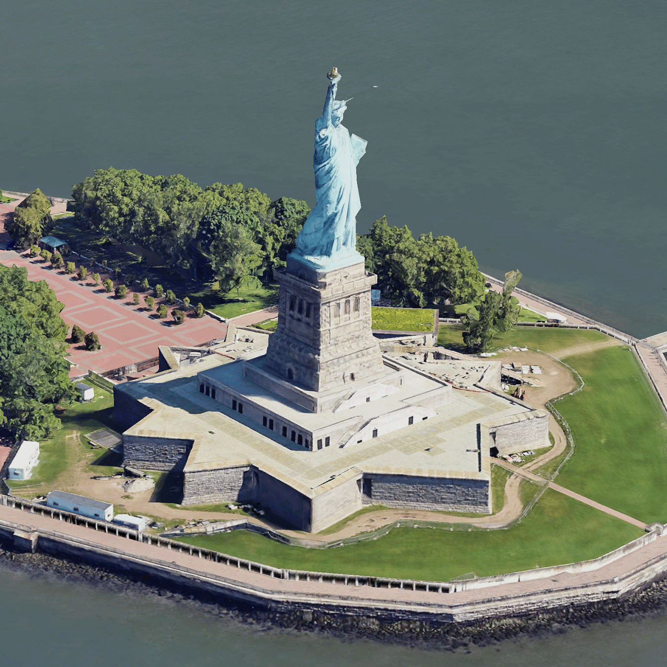
مربّعات ثلاثية الأبعاد لصور واقعية هي مربّعات خرائط تحتوي على بيانات جغرافية ثلاثية الأبعاد من Google بتنسيق OGC 3D Tiles.
يمكنك عرض خرائط Google الثلاثية الأبعاد باستخدام أداة العرض الخاصة بك لـ 3D Tiles، أو يمكنك استخدام مكتبة مفتوحة المصدر لعرض البيانات الجغرافية المكانية الثلاثية الأبعاد.
مزايا استخدام 3D Tiles
توفّر Google "مربّعات ثلاثية الأبعاد" لحالات استخدام العرض المرئي من الجيل التالي. يمكنك استخدام 3D Tiles لإنشاء عروض مذهلة ثلاثية الأبعاد، تمامًا كما يمكنك استخدام Google Earth. تساعد هذه المشاهد المستخدمين على فهم السياق الجغرافي بشكل أفضل، وتحسين طريقة تنقّلهم، ويمكنها عرض مكان مخصّص لسرد القصص. باستخدام أداة العرض التي تختارها، يمكنك أيضًا تحريك الكاميرا بسلاسة خلال مشهد لعرضه من زوايا مختلفة.
مناطق التغطية
راجِع التغطية في Map Tiles API. تُعدِّل Google الصور وتضيفها بانتظام.
حلول ثلاثية الأبعاد
يحتوي مركز تصميم Google Maps Platform على أمثلة لحلول ثلاثية الأبعاد يمكنك الاطّلاع عليها لبدء استخدام تطبيقك:
أداة استكشاف المناطق الثلاثية الأبعاد:
تتيح لك استكشاف الأحياء والمناطق افتراضيًا وبتقنية ثلاثية الأبعاد مع
درجة عالية من التفاصيل المرئية.
رواية القصص ثلاثية الأبعاد:
تجمع هذه الميزة بين رواية القصص ورسم الخرائط، ما يتيح لصنّاع المحتوى إنشاء روايات تفاعلية وشاملة باستخدام "مربّعات ثلاثية الأبعاد لصور واقعية".
إنّ محتوى هذه الصفحة مرخّص بموجب ترخيص Creative Commons Attribution 4.0 ما لم يُنصّ على خلاف ذلك، ونماذج الرموز مرخّصة بموجب ترخيص Apache 2.0. للاطّلاع على التفاصيل، يُرجى مراجعة سياسات موقع Google Developers. إنّ Java هي علامة تجارية مسجَّلة لشركة Oracle و/أو شركائها التابعين.
تاريخ التعديل الأخير: 2025-08-29 (حسب التوقيت العالمي المتفَّق عليه)
[null,null,["تاريخ التعديل الأخير: 2025-08-29 (حسب التوقيت العالمي المتفَّق عليه)"],[[["\u003cp\u003ePhotorealistic 3D Tiles are map tiles containing Google's 3D geodata in the OGC 3D Tiles format, allowing rendering with your own or open source 3D Tiles renderers.\u003c/p\u003e\n"],["\u003cp\u003e3D Tiles empowers next-generation visualization, enabling stunning 3D perspective views for enhanced geographic context, navigation, and storytelling.\u003c/p\u003e\n"],["\u003cp\u003eGoogle's 3D Tiles offer coverage detailed in the Map Tiles API documentation, with regular updates and imagery additions.\u003c/p\u003e\n"],["\u003cp\u003eExplore 3D solutions like the 3D Area Explorer for detailed virtual exploration and 3D Storytelling for immersive narratives using Photorealistic 3D Tiles on the Google Maps Platform Architecture Center.\u003c/p\u003e\n"]]],[],null,["# Photorealistic 3D Tiles overview\n\n**European Economic Area (EEA) developers** If your billing address is in the European Economic Area, effective on 8 July 2025, the [Google\n| Maps Platform EEA Terms of Service](https://cloud.google.com/terms/maps-platform/eea) will apply to your use of the Services. [Learn more](/maps/comms/eea/faq). In addition, certain content from the Map Tiles API will no longer be returned. [Learn more](/maps/comms/eea/map-tiles).\n\n:statue_of_liberty:Photorealistic 3D Tiles are map tiles that contain Google's 3D\ngeodata in the\n[OGC 3D Tiles format](https://www.ogc.org/standards/3DTiles).\nYou can render Google's 3D maps with your own 3D Tiles renderer, or you can use\nan open source library for 3D geospatial visualization.\n\nWhy use 3D Tiles?\n-----------------\n\nGoogle offers 3D Tiles for next-generation visualization use cases. You can use\n3D Tiles to build stunning 3D perspective views, just as you can with Google\nEarth. These views help your users better understand geographic context, improve\nhow they navigate, and they can showcase a place for storytelling. Using a\nrenderer of your choice, you can also smoothly maneuver your camera through a\nscene to view it from different angles.\n\nCoverage areas\n--------------\n\nReview the Map Tiles API's\n[coverage](/maps/coverage#countryregion-coverage). Google regularly updates and\nadds imagery.\n\n3D solutions\n------------\n\nThe [Google Maps Platform Architecture Center](/maps/architecture)\ncontains examples of 3D solutions that you can examine to get started with your\napp:\n\n- [3D Area Explorer](/maps/architecture/3d-area-explorer):\n Lets you explore neighborhoods and areas virtually and in 3D with a\n high degree of visual detail.\n\n- [3D Storytelling](/maps/architecture/3d-storytelling):\n Bridges storytelling and mapping, enabling creators to craft immersive and\n interactive narratives using Photorealistic 3D Tiles."]]