تنظيم صفحاتك في مجموعات
يمكنك حفظ المحتوى وتصنيفه حسب إعداداتك المفضّلة.
المطوّرون في المنطقة الاقتصادية الأوروبية
مربّعات ثلاثية الأبعاد لصور واقعية هي عبارة عن شبكة ثلاثية الأبعاد مزخرفة بصور عالية الدقة. وتوفّر هذه الخرائط صورًا ثلاثية الأبعاد بدرجة دقة عالية في العديد من المناطق المأهولة حول العالم. تتيح لك هذه الأدوات توفير تجارب عرض ثلاثي الأبعاد غامرة من الجيل التالي لمساعدة المستخدمين في ما يلي:
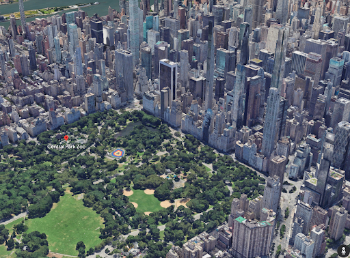
التعرّف على منطقة
التنقّل إلى موقع جغرافي بكل ثقة
تقييم أماكن جديدة لاتخاذ القرارات
فهم كيفية تغيُّر العالم الحقيقي
قبل البدء
قبل البدء في استخدام واجهة برمجة التطبيقات Photorealistic 3D Tiles API، عليك مراجعة بنود الخدمة وسياسات Map Tiles API. يمكنك بعد ذلك
بدء مشروع باستخدام حساب فوترة وتفعيل Map Tiles API. لمزيد من المعلومات، يُرجى الاطّلاع على الإعداد في Cloud Console.
الحصول على البلاطات
بعد الحصول على مفتاح واجهة برمجة التطبيقات، يمكنك البدء في الوصول إلى مربّعات الصور الواقعية من خلال تحديد عنوان URL لمجموعة مربّعات جذرية إلى أداة عرض 3D
Tiles التي تختارها. بعد ذلك، يتم تلقائيًا إجراء جميع الطلبات اللاحقة للحصول على مربّعات واقعية من خلال أداة العرض عندما يستكشف المستخدم النهائي الخريطة.
يمكن أن يقدّم العرض طلبات للحصول على مربّعات لمدة ثلاث ساعات على الأقل من طلب واحد لمجموعة مربّعات أساسية. بعد الوصول إلى هذا الحدّ، عليك تقديم طلب آخر لمجموعة مربّعات أساسية.
على سبيل المثال، يمكنك استخدام رمز JavaScript التالي لبدء استكشاف 3D
Tiles باستخدام Cesium
JS.
تاريخ التعديل الأخير: 2025-08-29 (حسب التوقيت العالمي المتفَّق عليه)
[null,null,["تاريخ التعديل الأخير: 2025-08-29 (حسب التوقيت العالمي المتفَّق عليه)"],[[["\u003cp\u003ePhotorealistic 3D Tiles provide high-resolution 3D maps of populated areas, enabling immersive visualization experiences for users.\u003c/p\u003e\n"],["\u003cp\u003eThese tiles help users understand, navigate, evaluate, and monitor changes in real-world locations.\u003c/p\u003e\n"],["\u003cp\u003eTo use the API, review the Terms of Service, Map Tiles API Policies, set up a billing account, enable the Map Tiles API, and obtain an API key.\u003c/p\u003e\n"],["\u003cp\u003eAccess tiles by providing a root tileset URL to a compatible 3D Tiles renderer (like CesiumJS) and ensure the renderer supports copyright attribution.\u003c/p\u003e\n"],["\u003cp\u003eA single root tileset request allows for at least three hours of tile requests before requiring a new request.\u003c/p\u003e\n"]]],["Photorealistic 3D Tiles provide high-resolution 3D maps, enabling users to understand areas, navigate confidently, evaluate locations, and observe real-world changes. To use the API, review the Terms of Service and API Policies, then set up a project with billing and enable the Map Tiles API. Access tiles by specifying a root tileset URL with an API key to a 3D Tiles renderer, which will automatically make subsequent tile requests. Renderers are allowed a maximum of 3 hours of requests per root request.\n"],null,["# Photorealistic 3D Tiles\n\n**European Economic Area (EEA) developers** If your billing address is in the European Economic Area, effective on 8 July 2025, the [Google\n| Maps Platform EEA Terms of Service](https://cloud.google.com/terms/maps-platform/eea) will apply to your use of the Services. [Learn more](/maps/comms/eea/faq). In addition, certain content from the Map Tiles API will no longer be returned. [Learn more](/maps/comms/eea/map-tiles).\n\nPhotorealistic 3D Tiles are a 3D mesh textured with high\nresolution imagery. They offer high-resolution 3D maps in many of the world's\npopulated areas. They let you power next-generation, immersive 3D\nvisualization experiences to help your users:\n\n- Understand an area\n\n- Confidently navigate to a location\n\n- Evaluate new places to make decisions\n\n- Understand how the real world changes\n\nBefore you begin\n----------------\n\nBefore you start using the Photorealistic 3D Tiles API, you need to review the\n[Terms of Service](https://cloud.google.com/maps-platform/terms/) and\n[Map Tiles API Policies](/maps/documentation/tile/policies). You may then\nstart a project with a billing account and enable the Map Tiles API. To\nlearn more, see [Setup in Cloud Console](/maps/documentation/tile/cloud-setup).\n\nGetting tiles\n-------------\n\nAfter obtaining your [API key](/maps/documentation/tile/get-api-key), you can\nbegin accessing photorealistic tiles by specifying a root tileset URL to a 3D\nTiles renderer of your choice. After that, all subsequent calls for\nphotorealistic tiles are automatically made by the renderer as the end user\nexplores the map.\n\nThe render can make at least three hours of tile requests from a single root\ntileset request. After reaching this limit, you must make another root tileset\nrequest.\n\nAs an example, you can use the following JavaScript code to start exploring 3D\nTiles with [Cesium\nJS](https://cesium.com/platform/cesiumjs/). \n\n \u003chead\u003e\n \u003cmeta charset=\"utf-8\"\u003e\n \u003cscript src=\"https://ajax.googleapis.com/ajax/libs/cesiumjs/1.105/Build/Cesium/Cesium.js\"\u003e\u003c/script\u003e\n \u003clink href=\"https://ajax.googleapis.com/ajax/libs/cesiumjs/1.105/Build/Cesium/Widgets/widgets.css\" rel=\"stylesheet\"\u003e\n \u003c/head\u003e\n\n \u003cbody\u003e\n \u003cdiv id=\"cesiumContainer\"\u003e\u003c/div\u003e\n \u003cscript\u003e\n const viewer = new Cesium.Viewer('cesiumContainer', {\n imageryProvider: false,\n baseLayerPicker: false,\n requestRenderMode: true,\n });\n\n const tileset = viewer.scene.primitives.add(new Cesium.Cesium3DTileset({\n url: \"https://tile.googleapis.com/v1/3dtiles/root.json?key=YOUR_API_KEY\",\n showCreditsOnScreen: true,\n }));\n\n viewer.scene.globe.show = false;\n \u003c/script\u003e\n \u003c/body\u003e\n\n| **Note:** To render Google's photorealistic tiles, you must use a 3D Tiles renderer that supports the display of copyright attribution. You can use **CesiumJS version 1.91** and later, or **Cesium for Unreal version 1.12** and later."]]