
Mã phiên là một phần dữ liệu (một
UUID)
được dùng trong các lệnh gọi REST để xác định một
phiên—một
chuỗi các trao đổi thông báo có liên quan. Bạn phải thêm mã phiên vào tất cả các yêu cầu về Ô bản đồ 2D và hình ảnh trong Chế độ xem đường phố.
Bạn thêm mã này làm giá trị của tham số session được thêm vào tất cả các URL yêu cầu.
Trong Map Tiles API, mã phiên đại diện cho một tập hợp các tuỳ chọn hiển thị đã xác định. Điều này có nghĩa là bạn không phải truyền một tập hợp các tuỳ chọn hiển thị với mỗi yêu cầu về ô. Bạn có thể sử dụng cùng một mã phiên trên nhiều ứng dụng.
Mã phiên hiện có hiệu lực trong 2 tuần kể từ thời điểm phát hành, nhưng điều này có thể thay đổi. Bạn luôn có thể kiểm tra thời gian hết hạn của mã phiên bằng cách xem trường expiry trong thông báo phản hồi.
Yêu cầu về mã phiên
Để yêu cầu mã phiên, hãy gửi yêu cầu HTTPS POST đến điểm cuối createSession, như trong ví dụ sau. Bạn phải gửi yêu cầu có tiêu đề Content-Type: application/json.
curl -X POST -d '{
  "mapType": "streetview",
  "language": "en-US",
  "region": "US"
}' \
-H 'Content-Type: application/json' \
"https://tile.googleapis.com/v1/createSession?key=YOUR_API_KEY"
Các trường bắt buộc
mapTypeLoại bản đồ cơ sở. Giá trị này có thể là một trong những giá trị sau:
roadmap- Các ô bản đồ được vẽ tiêu chuẩn của Google Maps.
satellite- Hình ảnh vệ tinh.
terrain- Hình ảnh địa hình. Khi chọn
terrainlàm loại bản đồ, bạn cũng phải thêm loại lớplayerRoadmap(được mô tả trong phần Trường không bắt buộc section). streetview- Ảnh toàn cảnh trong Chế độ xem đường phố. Để biết thêm thông tin, hãy xem bài viết Ô bản đồ Chế độ xem đường phố.
languageThẻ ngôn ngữ IETF chỉ định ngôn ngữ dùng để hiển thị thông tin trên các ô. Ví dụ:
en-USchỉ định ngôn ngữ tiếng Anh như được nói ở Hoa Kỳ.region
Trường tuỳ chọn
imageFormat- Chỉ định định dạng tệp cần trả về. Các giá trị hợp lệ là
jpeghoặcpng. Tệp JPEG không hỗ trợ độ trong suốt, do đó, bạn không nên dùng tệp này cho các ô lớp phủ. Nếu bạn không chỉ địnhimageFormat, thì hệ thống sẽ tự động chọn định dạng tốt nhất cho ô. scaleTăng tỷ lệ kích thước của các phần tử bản đồ (chẳng hạn như nhãn đường) trong khi vẫn giữ nguyên kích thước ô và khu vực phủ sóng của ô mặc định. Việc tăng tỷ lệ cũng làm giảm số lượng nhãn trên bản đồ, giúp giảm tình trạng lộn xộn. Các giá trị sau đây là giá trị
scalehợp lệ:scaleFactor1x: Giá trị mặc định.scaleFactor2x: Tăng gấp đôi kích thước nhãn và xoá nhãn tính năng nhỏ.scaleFactor4x: Tăng gấp 4 lần kích thước nhãn và xoá nhãn tính năng nhỏ.
Các ví dụ sau đây minh hoạ hiệu ứng của việc điều chỉnh tỷ lệ các phần tử bản đồ.
| Hệ số tỷ lệ 1x | Hệ số tỷ lệ 2x |
|---|---|
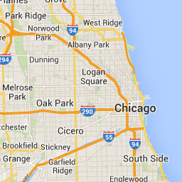 |
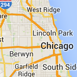 |
highDpi- Chỉ định có trả về ô có độ phân giải cao hay không. Nếu hệ số tỷ lệ tăng lên,
highDpisẽ được dùng để tăng kích thước của ô. Thông thường, việc tăng hệ số tỷ lệ sẽ phóng to ô kết quả thành hình ảnh có cùng kích thước, làm giảm chất lượng. VớihighDpi, kích thước kết quả cũng tăng lên, giúp duy trì chất lượng. DPI là viết tắt của Dots per Inch (Số điểm trên mỗi inch) và High DPI (Độ phân giải cao) có nghĩa là ô hiển thị bằng cách sử dụng nhiều số điểm trên mỗi inch hơn bình thường. Nếu làtrue, thì số lượng pixel trong mỗi chiều x và y sẽ được nhân với hệ số tỷ lệ (tức là 2x hoặc 4x). Khu vực đưa tin của ô vẫn không thay đổi. Tham số này chỉ hoạt động với các giá trịscalelà 2x hoặc 4x. Tham số này không ảnh hưởng đến các ô có tỷ lệ 1x.
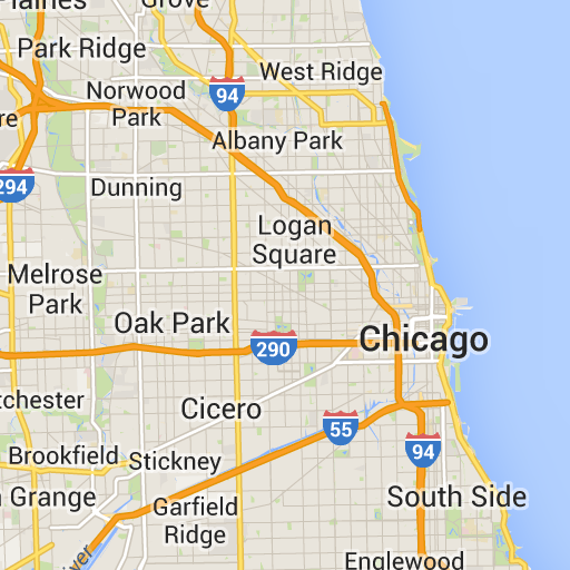
| Hệ số tỷ lệ 1x | Hệ số tỷ lệ 2x Độ phân giải cao |
|---|---|
|
 |
layerTypesMột mảng các giá trị chỉ định các loại lớp được thêm vào bản đồ. Các giá trị hợp lệ là:
layerRoadmap- Bắt buộc nếu bạn chỉ định
terrainlàm loại bản đồ. Cũng có thể được phủ lên loại bản đồsatellite(không bắt buộc). Không ảnh hưởng đến các ô bản đồ đường đi. layerStreetview- Hiển thị các đường phố và địa điểm có Chế độ xem đường phố bằng đường viền màu xanh dương trên bản đồ.
layerTraffic- Hiển thị tình trạng giao thông hiện tại.
stylesMột mảng các đối tượng kiểu JSON chỉ định hình thức và mức độ chi tiết của các tính năng trên bản đồ, chẳng hạn như đường, công viên và khu vực xây dựng. Kiểu được dùng để tuỳ chỉnh bản đồ cơ sở tiêu chuẩn của Google. Tham số
styleschỉ hợp lệ nếu loại bản đồ làroadmap. Để biết cú pháp kiểu hoàn chỉnh, hãy xem Tài liệu tham khảo về kiểu.overlayGiá trị boolean chỉ định có nên hiển thị
layerTypesdưới dạng lớp phủ riêng biệt hay kết hợp với hình ảnh cơ sở. Khi làtrue, bản đồ cơ sở sẽ không hiển thị. Nếu bạn chưa xác định bất kỳlayerTypesnào, thì giá trị này sẽ bị bỏ qua.
Ví dụ: yêu cầu loại bản đồ satellite có lớp layerRoadmap và overlay được đặt thành false sẽ tạo ra các ô tương đương với loại bản đồ hybrid được dùng trong API JavaScript của Maps (hình ảnh bên trái). Cùng một loại bản đồ và lớp có overlay được đặt thành true sẽ tạo ra một ô trong suốt có lớp phủ bản đồ, được tạo kiểu phù hợp để phủ lên hình ảnh vệ tinh (hình ảnh bên phải).
overlay: false |
overlay: true |
|---|---|
 |
 |
JSON sau đây là ví dụ về một nội dung yêu cầu thông thường chứa cả trường bắt buộc và trường không bắt buộc.
{
  "mapType": "satellite",
  "language": "en-US",
  "region": "us",
  "layerTypes": [ "layerRoadmap", "layerStreetview" ],
  "overlay":  true,
  "scale": "scaleFactor1x",
  "styles": [
    {
      "stylers": [
        { "hue": "#00ffe6" },
        { "saturation": -20 }
      ]
    },{
      "featureType": "road",
      "elementType": "geometry",
      "stylers": [
        { "lightness": 100 },
        { "visibility": "simplified" }
      ]
    }
  ]
}
Ví dụ này cung cấp một lớp phủ phù hợp để kết hợp với hình ảnh vệ tinh. Ví dụ này chứa cả lớp phủ bản đồ đường đi và lớp phủ chế độ xem đường phố. Bản đồ kết quả được hiển thị bằng tên và dữ liệu bằng tiếng Anh, như được nói ở Hoa Kỳ.
Phản hồi bằng mã phiên
JSON sau đây là ví dụ về nội dung phản hồi.
{
  "session": "IgAAAHGU9jnAU4KOAfwY3Bcd6eH_WxQsyocSBAdUnAr9pnvTTNXtF9c_27RBo94ytEXTDg",
  "expiry": "1361828036",
  "tileWidth": 256,
  "tileHeight": 256,
  "imageFormat": "png"
}
Danh sách sau đây chứa định nghĩa của các trường trong nội dung phản hồi.
session- Giá trị mã phiên mà bạn phải thêm vào tất cả các yêu cầu Map Tiles API.
expiry- Một chuỗi chứa thời gian (tính bằng giây kể từ thời điểm bắt đầu hệ thống) mà mã thông báo hết hạn. Mã phiên có hiệu lực trong 2 tuần kể từ thời điểm tạo, nhưng chính sách này có thể thay đổi mà không cần thông báo.
tileWidth- Chiều rộng của các ô được đo bằng pixel.
tileHeight- Chiều cao của các ô được đo bằng pixel.
imageFormat- Định dạng hình ảnh, có thể là
pnghoặcjpeg.