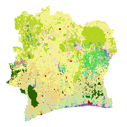
코트디부아르 BNETD 2020 토지 피복 지도는 코트디부아르 정부가 국가 기관인 국립 연구 사무소 기술 및 개발 (BNETD-CIGN)의 지리 정보 및 디지털 센터를 통해 유럽 연합의 기술 및 재정 지원을 받아 제작했습니다. 지도를 제작하는 데 사용된 방법론은 투명하고 참여적이며 국제 표준을 준수합니다.
이 지도를 개발하기 위해 2020년 위성 이미지 (Sentinel 2) 모자이크를 Google Earth Engine을 통해 처리하고 현장에서 수집한 데이터를 보완하여 지도 학습 분류 알고리즘 (Random Forest)을 학습시켰습니다.
2022년 11월 10일부터 12월 9일까지, 2023년 1월 26일부터 2월 13일까지 두 차례에 걸쳐 전국에서 현장 캠페인이 진행되었습니다. 이러한 미션에는 여러 파트너 조직의 33명이 참여했습니다. 이해관계자가 채택한 데이터 수집 방법과 특정 토지 이용 분류의 정의가 때때로 다를 수 있기 때문입니다.
EUDR 실사 과정의 일환으로 EUDR 관련 제품을 생산하는 토지의 지리적 위치 데이터는 2020년 산림 피복 데이터와 중첩되어 해당 토지가 2020년 기준일 이전에 산림이었던 지역에 위치할 위험을 평가할 수 있습니다. 이를 위해서는 FAO의 산림 정의 및 2020년 기준일에 부합하는 산림 피복 데이터가 필요합니다. 코트디부아르의 2020년 토지 피복 지도는 이러한 요구사항을 충족합니다.
실제로 토지 피복 지도에 있는 클래스를 결합하여 FAO의 산림 정의에 부합하는 산림/비산림 지도를 만들 수 있습니다.
2020년 토지 피복 데이터, 메타데이터, 방법론에 액세스하기 위한 플랫폼이 데이터 분석 및 시각화를 위해 Africa GeoPortal의 ESRI 솔루션을 사용하여 개발되었습니다.
[null,null,[],[[["\u003cp\u003eThe Cote d'Ivoire BNETD 2020 Land Cover Map provides a detailed classification of land cover across Cote d'Ivoire for the year 2020, created using Sentinel 2 satellite imagery and ground-truthed data.\u003c/p\u003e\n"],["\u003cp\u003eThis dataset, produced by the Ivorian Government with support from the European Union, follows international standards and offers 10-meter resolution for analysis.\u003c/p\u003e\n"],["\u003cp\u003eUsers can access the dataset through Google Earth Engine and the Africa GeoPortal for visualization and analysis, with the possibility of overlaying it with other data for due diligence purposes like assessing deforestation risk.\u003c/p\u003e\n"],["\u003cp\u003eThe land cover classifications include a variety of forest types, plantations, agricultural areas, water bodies, and human infrastructure, allowing for comprehensive land use assessments.\u003c/p\u003e\n"],["\u003cp\u003eThe dataset is available under a CC-BY-4.0 license, encouraging open access and use for research, education, and non-profit purposes.\u003c/p\u003e\n"]]],[],null,["# Cote d'Ivoire BNETD 2020 Land Cover Map\n\nDataset Availability\n: 2020-01-01T00:00:00Z--2021-01-01T00:00:00Z\n\nDataset Provider\n:\n\n\n [BNETD-CIGN](https://africageoportal.maps.arcgis.com/home/user.html?user=bnetdcignCI)\n\nCadence\n: 1 Year\n\nTags\n:\n[classification](/earth-engine/datasets/tags/classification) [deforestation](/earth-engine/datasets/tags/deforestation) [forest](/earth-engine/datasets/tags/forest) [landcover](/earth-engine/datasets/tags/landcover) [landuse-landcover](/earth-engine/datasets/tags/landuse-landcover) \n\n#### Description\n\nThe Cote d'Ivoire BNETD 2020 Land Cover Map was produced by the Ivorian\nGovernment through a national institution, the Center for Geographic\nInformation and Digital from the National Study Office Techniques and\nDevelopment (BNETD-CIGN), with technical and financial support from the\nEuropean Union. The methodology used to produce the map was transparent,\nparticipatory and in line with international standards.\n\nTo develop this map, a mosaic of satellite images (Sentinel 2) from 2020 was\nprocessed via Google Earth Engine and supplemented with data collected in the\nfield, to train a supervised classification algorithm (Random Forest).\nTwo field campaigns were conducted, from 10 November to 9 December 2022 and\nfrom 26 January to 13 February 2023, throughout the country. These missions\ninvolved 33 people from multiple partner organizations because the data\ncollection methods and definitions of certain land use classes\nadopted by stakeholders may sometimes differ.\n\nAs part of the EUDR due diligence process, geolocation data for plots of\nland producing EUDR-relevant products could be overlaid with 2020 forest\ncover data in order to assess the risk that the plot is located in an area\nthat was forested before the 2020 cut-off date. To do this, forest cover\ndata aligned with the FAO definition of forests and the 2020 cut-off date\nis required. The 2020 land cover map of Cote d'Ivoire meets these needs.\nIndeed, the classes in the land cover map can be combined to create a\nforest/non-forest map that is aligned with the FAO definition of forests.\n\nA platform for accessing 2020 land cover data, metadata and the methodology\nhas been developed using ESRI solutions, from Africa GeoPortal, for data\nanalysis and visualization:\n\nThe address is: \u003chttps://bit.ly/carte-ci-2020\u003e\n\nDocumentation:\n\n- [Detailed documentation](https://africageoportal.maps.arcgis.com/sharing/rest/content/items/26a717d4c13f4f3db2c6056f7e5c0bab/data)\n\n- [Methodology in French](https://africageoportal.maps.arcgis.com/sharing/rest/content/items/76dc18767b89472eb89e8aa54e08a6c9/data)\n\n### Bands\n\n\n**Pixel Size**\n\n10 meters\n\n**Bands**\n\n| Name | Min | Max | Pixel Size | Description |\n|------------------|-----|-----|------------|------------------|\n| `classification` | 1 | 23 | meters | Land Cover class |\n\n**classification Class Table**\n\n| Value | Color | Description |\n|-------|---------|-------------------------------------------------------------------------------------------------------------------|\n| 1 | #276300 | Dense forest (Forêt dense) |\n| 2 | #59D757 | Light forest (Forêt claire) |\n| 3 | #569D6E | Forest gallery (Forêt galerie) |\n| 4 | #79CFAD | Secondary forest/degraded forest (Forêt secondaire/forêt dégradée) |\n| 5 | #34734C | Mangrove |\n| 6 | #B4FFAD | Forest plantation/Reforestation (Plantation forestière/Reboisement) |\n| 7 | #6EFA9A | Swamp forest/Forest on hydromorphic soil (Forêt marécageuse/Forêt sur sol hydromorphe) |\n| 8 | #D68589 | Coffee Plantation (Plantation de Café) |\n| 9 | #EBD37F | Cocoa Plantation (Plantation de Cacao) |\n| 10 | #D0E09D | Rubber plantation (Plantation d'Hévéa) |\n| 11 | #E8BEFF | Oil palm plantation (Plantation de Palmier à huile) |\n| 12 | #E751FE | Coconut Plantation (Plantation de Coco) |\n| 13 | #F3BFF2 | Cashew plantation (Plantation d'Anacarde) |\n| 14 | #9DFD00 | Fruit plantation / Arboriculture (Plantation fruitière / Arboricultures) |\n| 15 | #F2F38D | Agricultural development/Other crops/Orchards/Fallow land (Aménagement agricole/Autres cultures/Vergers/Jachères) |\n| 16 | #B6D322 | Tree savannah (Savane arborée) |\n| 17 | #E2FE5F | Shrub formations/ Thickets (Formations arbustives/ Fourrés) |\n| 18 | #F9FDCC | Herbaceous formations (Formations herbacées) |\n| 19 | #4A70C0 | Body of water, Courses and waterways (Plan d'eau, Cours et voies deau) |\n| 20 | #BEFFE8 | Swampy area (Zone marécageuse) |\n| 21 | #D20A02 | Human habitat, Infrastructure (Habitat humain, Infrastructures) |\n| 22 | #DBECEF | Rocky outcrop (Affleurement rocheux) |\n| 23 | #DCDCDC | Bare ground (Sol nu) |\n\n### Terms of Use\n\n**Terms of Use**\n\n[CC-BY-4.0](https://spdx.org/licenses/CC-BY-4.0.html)\n\n### Citations\n\nCitations:\n\n- BNETD Land Cover Map 2020.\n\n### Explore with Earth Engine\n\n| **Important:** Earth Engine is a platform for petabyte-scale scientific analysis and visualization of geospatial datasets, both for public benefit and for business and government users. Earth Engine is free to use for research, education, and nonprofit use. To get started, please [register for Earth Engine access.](https://console.cloud.google.com/earth-engine)\n\n### Code Editor (JavaScript)\n\n```javascript\nvar dataset = ee.Image('BNETD/land_cover/v1/2020').select('classification');\n\nMap.setCenter(-5.4400, 7.5500, 7);\n\nMap.addLayer(dataset, {}, \"Cote d'Ivoire Land Cover Map 2020\");\n```\n[Open in Code Editor](https://code.earthengine.google.com/?scriptPath=Examples:Datasets/BNETD/BNETD_land_cover_v1) \n[Cote d'Ivoire BNETD 2020 Land Cover Map](/earth-engine/datasets/catalog/BNETD_land_cover_v1) \nThe Cote d'Ivoire BNETD 2020 Land Cover Map was produced by the Ivorian Government through a national institution, the Center for Geographic Information and Digital from the National Study Office Techniques and Development (BNETD-CIGN), with technical and financial support from the European Union. The methodology used to produce the map ... \nBNETD/land_cover/v1, classification,deforestation,forest,landcover,landuse-landcover \n2020-01-01T00:00:00Z/2021-01-01T00:00:00Z \n4.3603 -8.602 10.74 -2.493 \nGoogle Earth Engine \nhttps://developers.google.com/earth-engine/datasets\n\n- [](https://doi.org/https://africageoportal.maps.arcgis.com/home/user.html?user=bnetdcignCI)\n- [](https://doi.org/https://developers.google.com/earth-engine/datasets/catalog/BNETD_land_cover_v1)"]]