- Доступность набора данных
- 2020-01-01T00:00:00Z–2021-01-01T00:00:00Z
- Поставщик наборов данных
- BNETD-CIGN
- Каденция
- 1 год
- Теги
Описание
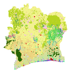
Карта земельного покрова Кот-д'Ивуара BNETD 2020 была подготовлена правительством Кот-д'Ивуара через национальный институт – Центр географической информации и цифровых технологий Национального бюро исследований, технологий и развития (BNETD-CIGN) – при технической и финансовой поддержке Европейского союза. Методология, использованная при создании карты, была прозрачной, предполагала участие всех участников и соответствовала международным стандартам.
Для создания этой карты мозаика спутниковых снимков (Sentinel 2) 2020 года была обработана с помощью Google Earth Engine и дополнена данными, собранными в полевых условиях, для обучения контролируемого алгоритма классификации (Random Forest). Были проведены две полевые кампании: с 10 ноября по 9 декабря 2022 года и с 26 января по 13 февраля 2023 года по всей стране. В этих миссиях приняли участие 33 человека из нескольких организаций-партнеров, поскольку методы сбора данных и определения некоторых классов землепользования, принятые заинтересованными сторонами, иногда могут различаться.
В рамках процедуры комплексной проверки EUDR геолокационные данные по участкам земли, на которых производится продукция, соответствующая требованиям EUDR, могут быть наложены на данные о лесном покрове за 2020 год для оценки риска того, что участок расположен на территории, которая была покрыта лесом до даты прекращения лесного хозяйства в 2020 году. Для этого необходимы данные о лесном покрове, соответствующие определению лесов ФАО и дате прекращения лесного хозяйства в 2020 году. Карта земельного покрова Кот-д'Ивуара за 2020 год отвечает этим требованиям. Действительно, классы на карте земельного покрова можно объединить для создания карты лесов/нелесных территорий, соответствующей определению лесов ФАО.
Платформа для доступа к данным о земельном покрове за 2020 год, метаданным и методологии была разработана с использованием решений ESRI из Africa GeoPortal для анализа и визуализации данных:
Адрес: https://bit.ly/carte-ci-2020
Документация:
Группы
Размер пикселя
10 метров
Группы
| Имя | Мин. | Макс | Размер пикселя | Описание |
|---|---|---|---|---|
classification | 1 | 23 | метров | Класс земельного покрова |
Таблица классов классификации
| Ценить | Цвет | Описание |
|---|---|---|
| 1 | #276300 | Густой лес (Forêt dense) |
| 2 | #59D757 | Light forest (Forêt claire) |
| 3 | #569D6E | Лесная галерея (Forêt galerie) |
| 4 | #79CFAD | Вторичный лес/деградированный лес (Forêt Secondaire/Forêt Dégradée) |
| 5 | #34734C | Мангровые заросли |
| 6 | #B4FFAD | Лесные плантации/Восстановление лесов (Plantation Forestière/Reboisement) |
| 7 | #6EFA9A | Болотный лес/Лес на гидроморфной почве (Forêt marécageuse/Forêt sur sol Hydromorphe) |
| 8 | #D68589 | Кофейная плантация (Plantation de Café) |
| 9 | #EBD37F | Плантация какао (Plantation de Cacao) |
| 10 | #D0E09D | Резиновая плантация (Plantation d'Hévea) |
| 11 | #E8BEFF | Плантация масличных пальм (Plantation de Palmier à huile) |
| 12 | #E751FE | Кокосовая плантация (Plantation de Coco) |
| 13 | #F3BFF2 | Плантация кешью (Plantation d'Anacarde) |
| 14 | #9DFD00 | Фруктовые плантации/Арборикультура (Plantation Fruitière/Arboriculturals) |
| 15 | #F2F38D | Развитие сельского хозяйства/Другие культуры/Сады/Паровые земли (Aménagement Agricole/Autres Cultures/Vergers/Jachères) |
| 16 | #B6D322 | Древовидная саванна (Savane arborée) |
| 17 | #E2FE5F | Кустарниковые формации/заросли (древесные формации/Фуррес) |
| 18 | #F9FDCC | Травянистые образования (Formations herbacées) |
| 19 | #4A70C0 | Водоем, поля и водные пути (Plan d'eau, Cours et voies deau) |
| 20 | #BEFFE8 | Болотистая местность (Zone marécageuse) |
| 21 | #D20A02 | Среда обитания человека, Инфраструктура (Habitat humain, Инфраструктуры) |
| 22 | #DBECEF | Скальное обнажение (Affleurement rocheux) |
| 23 | #DCDCDC | Голая земля (Sol nu) |
Условия эксплуатации
Условия эксплуатации
Цитаты
Карта земельного покрова BNETD 2020 года.
Исследуйте с Earth Engine
Редактор кода (JavaScript)
var dataset = ee.Image('BNETD/land_cover/v1/2020').select('classification');

Map.setCenter(-5.4400, 7.5500, 7);

Map.addLayer(dataset, {}, "Cote d'Ivoire Land Cover Map 2020");