- Доступность набора данных
- 2006-01-24T00:00:00Z–2011-05-13T00:00:00Z
- Поставщик наборов данных
- Партнеры по науке сохранения природы
- Теги
Описание
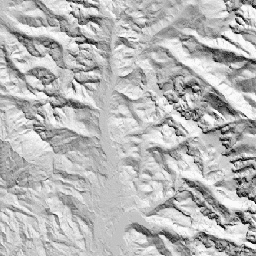
CHILI — это суррогатный показатель влияния инсоляции и топографического затенения на эвапотранспирацию, рассчитываемый путём расчёта инсоляции в начале полудня на высоте солнца, эквивалентной равноденствию. Он основан на 30-метровой цифровой модели рельефа SRTM (доступной в EE как USGS/SRTMGL1_003).
Наборы данных по экологически релевантной геоморфологии (ERGo), формам рельефа и физиографии, разработанные Conservation Science Partners (CSP), содержат подробные многомасштабные данные о формах рельефа и физиографических (т.н. «фасетных» характеристиках рельефа). Несмотря на множество потенциальных применений этих данных, изначальной целью их создания была разработка экологически релевантной классификации и карты форм рельефа и физиографических классов, подходящих для планирования адаптации к изменению климата. В связи с высокой неопределенностью, связанной с будущими климатическими условиями, и еще большей неопределенностью, связанной с экологическими реакциями, предоставление информации о том, что вряд ли изменится, дает руководителям надежную основу для разработки надежных планов адаптации к изменению климата. Количественная оценка этих характеристик ландшафта чувствительна к разрешению, поэтому мы предоставляем максимально возможное разрешение с учетом масштаба и характеристик данного индекса.
Группы
Размер пикселя
90 метров
Группы
| Имя | Мин. | Макс | Размер пикселя | Описание |
|---|---|---|---|---|
constant | 0 | 255 | метров | Индекс CHILI, рассчитанный по данным SRTM, варьируется от 0 (очень прохладный) до 255 (очень тёплый). В публикации он был пересчитан из диапазона [0,1]. |
Условия эксплуатации
Условия эксплуатации
Цитаты
Теобальд, Д.М., Харрисон-Атлас, Д., Монахан, У.Б., и Альбано, К.М. (2015). Экологически значимые карты рельефа и физико-географического разнообразия для планирования адаптации к изменению климата. PloS one, 10(12), e0143619
Исследуйте с Earth Engine
Редактор кода (JavaScript)
var dataset = ee.Image('CSP/ERGo/1_0/Global/SRTM_CHILI');
var srtmChili = dataset.select('constant');
var srtmChiliVis = {
  min: 0.0,
  max: 255.0,
};
Map.setCenter(-105.8636, 40.3439, 11);
Map.addLayer(srtmChili, srtmChiliVis, 'SRTM CHILI');