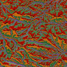
ALOS 지형 데이터 세트는 연속 열-일사량 부하 지수 (CHILI)와 다중 스케일 지형 위치 지수 (mTPI) 데이터 세트를 결합하여 생성된 지형 클래스를 제공합니다. USGS/NED로 EE에서 사용할 수 있는 USGS의 10m NED DEM을 기반으로 합니다.
Conservation Science Partners (CSP)의 생태학적으로 관련된 지형학(ERGo) 데이터 세트, 지형 및 지형학에는 지형 및 지형학 (즉, 토지 패싯) 패턴에 관한 상세한 다중 스케일 데이터가 포함되어 있습니다. 이러한 데이터는 다양한 용도로 사용될 수 있지만, 원래 목적은 기후 적응 계획에 적합한 지형 및 지형학적 분류와 지도를 개발하는 것이었습니다. 미래 기후 조건과 생태학적 반응에 대한 불확실성이 크기 때문에 변화가 없을 가능성이 높은 요소에 관한 정보를 제공하면 관리자가 강력한 기후 적응 계획을 수립할 수 있는 강력한 기반이 됩니다. 이러한 지형의 특징은 해상도에 민감하므로 특정 지수의 범위와 특성을 고려하여 가능한 가장 높은 해상도를 제공합니다.
ALOS 지형 데이터 세트는 연속 열-일사량 부하 지수 (CHILI)와 다중 스케일 지형 위치 지수 (mTPI) 데이터 세트를 결합하여 생성된 지형 클래스를 제공합니다. USGS의 10m NED DEM (EE에서 USGS/NED로 제공)을 기반으로 합니다. 보존 과학 파트너 (CSP) 생태학적으로 관련된 지형학 (ERGo) 데이터 세트, 지형 및 …
[null,null,[],[[["\u003cp\u003eThe ALOS Landform dataset provides landform classes by combining CHILI and mTPI datasets, based on the USGS's 10m NED DEM.\u003c/p\u003e\n"],["\u003cp\u003eThe dataset was developed for climate adaptation planning by classifying landforms and physiographic patterns.\u003c/p\u003e\n"],["\u003cp\u003eIt offers 10-meter resolution and includes 15 distinct landform classes, such as peaks, ridges, slopes, and valleys.\u003c/p\u003e\n"],["\u003cp\u003eThe dataset is provided by Conservation Science Partners and is licensed under CC-BY-NC-SA-4.0.\u003c/p\u003e\n"],["\u003cp\u003eIt covers the United States and is available in Google Earth Engine for analysis and visualization.\u003c/p\u003e\n"]]],[],null,["# US NED Landforms\n\nDataset Availability\n: 2006-01-24T00:00:00Z--2011-05-13T00:00:00Z\n\nDataset Provider\n:\n\n\n [Conservation Science Partners](https://www.csp-inc.org/)\n\nTags\n:\n[aspect](/earth-engine/datasets/tags/aspect) [csp](/earth-engine/datasets/tags/csp) [elevation](/earth-engine/datasets/tags/elevation) [elevation-topography](/earth-engine/datasets/tags/elevation-topography) [ergo](/earth-engine/datasets/tags/ergo) [geophysical](/earth-engine/datasets/tags/geophysical) [landforms](/earth-engine/datasets/tags/landforms) [slope](/earth-engine/datasets/tags/slope) [topography](/earth-engine/datasets/tags/topography) [us](/earth-engine/datasets/tags/us) \n\n#### Description\n\nThe ALOS Landform dataset provides landform classes created by combining\nthe Continuous Heat-Insolation Load Index (CHILI) and the\nmulti-scale Topographic Position Index (mTPI) datasets. It is\nbased on the USGS's 10m NED DEM (available in EE as USGS/NED).\n\nThe Conservation Science Partners (CSP) Ecologically Relevant Geomorphology\n(ERGo) Datasets, Landforms and Physiography contain detailed, multi-scale\ndata on landforms and physiographic (aka land facet) patterns. Although\nthere are many potential uses of these data, the original purpose for these\ndata was to develop an ecologically relevant classification and map of\nlandforms and physiographic classes that are suitable for climate adaptation\nplanning. Because there is large uncertainty associated with future climate\nconditions and even more uncertainty around ecological responses, providing\ninformation about what is unlikely to change offers a strong foundation for\nmanagers to build robust climate adaptation plans. The quantification of\nthese features of the landscape is sensitive to the resolution, so we\nprovide the highest resolution possible given the extent and characteristics\nof a given index.\n\n### Bands\n\n\n**Pixel Size**\n\n10 meters\n\n**Bands**\n\n| Name | Pixel Size | Description |\n|------------|------------|------------------------------|\n| `constant` | meters | NED-derived landform classes |\n\n**constant Class Table**\n\n| Value | Color | Description |\n|-------|---------|--------------------|\n| 11 | #141414 | Peak/ridge (warm) |\n| 12 | #383838 | Peak/ridge |\n| 13 | #808080 | Peak/ridge (cool) |\n| 14 | #ebeb8f | Mountain/divide |\n| 15 | #f7d311 | Cliff |\n| 21 | #aa0000 | Upper slope (warm) |\n| 22 | #d89382 | Upper slope |\n| 23 | #ddc9c9 | Upper slope (cool) |\n| 24 | #dccdce | Upper slope (flat) |\n| 31 | #1c6330 | Lower slope (warm) |\n| 32 | #68aa63 | Lower slope |\n| 33 | #b5c98e | Lower slope (cool) |\n| 34 | #e1f0e5 | Lower slope (flat) |\n| 41 | #a975ba | Valley |\n| 42 | #6f198c | Valley (narrow) |\n\n### Terms of Use\n\n**Terms of Use**\n\n[CC-BY-NC-SA-4.0](https://spdx.org/licenses/CC-BY-NC-SA-4.0.html)\n\n### Citations\n\nCitations:\n\n- Theobald, D. M., Harrison-Atlas, D., Monahan, W. B., \\& Albano, C. M.\n (2015). Ecologically-relevant maps of landforms and physiographic diversity\n for climate adaptation planning. PloS one, 10(12),\n [e0143619](https://journals.plos.org/plosone/article?id=10.1371/journal.pone.0143619)\n\n### Explore with Earth Engine\n\n| **Important:** Earth Engine is a platform for petabyte-scale scientific analysis and visualization of geospatial datasets, both for public benefit and for business and government users. Earth Engine is free to use for research, education, and nonprofit use. To get started, please [register for Earth Engine access.](https://console.cloud.google.com/earth-engine)\n\n### Code Editor (JavaScript)\n\n```javascript\nvar dataset = ee.Image('CSP/ERGo/1_0/US/landforms');\nvar landforms = dataset.select('constant');\nvar landformsVis = {\n min: 11.0,\n max: 42.0,\n palette: [\n '141414', '383838', '808080', 'ebeb8f', 'f7d311', 'aa0000', 'd89382',\n 'ddc9c9', 'dccdce', '1c6330', '68aa63', 'b5c98e', 'e1f0e5', 'a975ba',\n '6f198c'\n ],\n};\nMap.setCenter(-105.58, 40.5498, 11);\nMap.addLayer(landforms, landformsVis, 'Landforms');\n```\n[Open in Code Editor](https://code.earthengine.google.com/?scriptPath=Examples:Datasets/CSP/CSP_ERGo_1_0_US_landforms) \n[US NED Landforms](/earth-engine/datasets/catalog/CSP_ERGo_1_0_US_landforms) \nThe ALOS Landform dataset provides landform classes created by combining the Continuous Heat-Insolation Load Index (CHILI) and the multi-scale Topographic Position Index (mTPI) datasets. It is based on the USGS's 10m NED DEM (available in EE as USGS/NED). The Conservation Science Partners (CSP) Ecologically Relevant Geomorphology (ERGo) Datasets, Landforms and ... \nCSP/ERGo/1_0/US/landforms, aspect,csp,elevation,elevation-topography,ergo,geophysical,landforms,slope,topography,us \n2006-01-24T00:00:00Z/2011-05-13T00:00:00Z \n12.54 -132.09 56.21 -60.35 \nGoogle Earth Engine \nhttps://developers.google.com/earth-engine/datasets\n\n- [](https://doi.org/https://www.csp-inc.org/)\n- [](https://doi.org/https://developers.google.com/earth-engine/datasets/catalog/CSP_ERGo_1_0_US_landforms)"]]