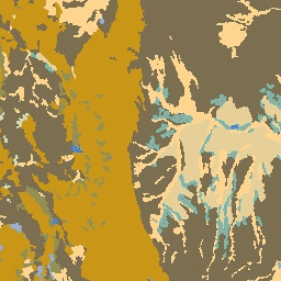
암석학 데이터 세트는 표면의 토양 모재의 일반적인 유형 클래스를 제공합니다. DEM에서 파생되지 않습니다.
Conservation Science Partners (CSP)의 생태학적으로 관련된 지형학(ERGo) 데이터 세트, 지형 및 지형학에는 지형 및 지형학 (즉, 토지 패싯) 패턴에 관한 상세한 다중 스케일 데이터가 포함되어 있습니다. 이러한 데이터는 다양한 용도로 사용될 수 있지만, 원래 목적은 기후 적응 계획에 적합한 지형 및 지형학적 분류와 지도를 개발하는 것이었습니다. 미래 기후 조건과 생태학적 반응에 대한 불확실성이 크기 때문에 변화가 없을 가능성이 높은 요소에 관한 정보를 제공하면 관리자가 강력한 기후 적응 계획을 수립할 수 있는 강력한 기반이 됩니다. 이러한 지형의 특징은 해상도에 민감하므로 특정 지수의 범위와 특성을 고려하여 가능한 가장 높은 해상도를 제공합니다.
암석학 데이터 세트는 표면의 토양 모재의 일반적인 유형의 클래스를 제공합니다. 어떤 DEM에서도 파생되지 않습니다. Conservation Science Partners (CSP) Ecologically Relevant Geomorphology (ERGo) 데이터 세트, 지형 및 지형학에는 지형 및 지형학 (즉, 지형학적 특징) 패턴에 관한 상세한 다중 스케일 데이터가 포함되어 있습니다. 하지만 …
[null,null,[],[[["\u003cp\u003eThe Lithology dataset classifies the general types of parent material of soil on the surface across the US.\u003c/p\u003e\n"],["\u003cp\u003eIt is part of the Conservation Science Partners (CSP) Ecologically Relevant Geomorphology (ERGo) datasets, focusing on landforms and physiographic patterns.\u003c/p\u003e\n"],["\u003cp\u003eThe dataset is available at a 90-meter resolution and covers the period from January 24, 2006, to May 13, 2011.\u003c/p\u003e\n"],["\u003cp\u003eIt includes a single band representing 20 different lithology classes, such as water, carbonate, and various sediment types.\u003c/p\u003e\n"],["\u003cp\u003eThis dataset is intended for climate adaptation planning and ecological research, providing insights into landform characteristics that are unlikely to change significantly over time.\u003c/p\u003e\n"]]],["The Lithology dataset, provided by Conservation Science Partners, classifies general soil parent material types. The data, part of the ERGo Datasets, spans from January 24, 2006, to May 13, 2011, and is accessible via an Earth Engine snippet. It includes 21 classes of lithology. The dataset is not based on DEM. The dataset includes information on landforms and physiography for climate adaptation planning with 90-meter pixel size. The data is under a CC-BY-NC-SA-4.0 license.\n"],null,["# US Lithology\n\nDataset Availability\n: 2006-01-24T00:00:00Z--2011-05-13T00:00:00Z\n\nDataset Provider\n:\n\n\n [Conservation Science Partners](https://www.csp-inc.org/)\n\nTags\n:\n[aspect](/earth-engine/datasets/tags/aspect) [csp](/earth-engine/datasets/tags/csp) [elevation](/earth-engine/datasets/tags/elevation) [elevation-topography](/earth-engine/datasets/tags/elevation-topography) [ergo](/earth-engine/datasets/tags/ergo) [geophysical](/earth-engine/datasets/tags/geophysical) [landforms](/earth-engine/datasets/tags/landforms) [slope](/earth-engine/datasets/tags/slope) [topography](/earth-engine/datasets/tags/topography) [us](/earth-engine/datasets/tags/us) \n\n#### Description\n\nThe Lithology dataset provides classes of the general types of parent\nmaterial of soil on the surface. It is not derived from any DEM.\n\nThe Conservation Science Partners (CSP) Ecologically Relevant Geomorphology\n(ERGo) Datasets, Landforms and Physiography contain detailed, multi-scale\ndata on landforms and physiographic (aka land facet) patterns. Although\nthere are many potential uses of these data, the original purpose for these\ndata was to develop an ecologically relevant classification and map of\nlandforms and physiographic classes that are suitable for climate adaptation\nplanning. Because there is large uncertainty associated with future climate\nconditions and even more uncertainty around ecological responses, providing\ninformation about what is unlikely to change offers a strong foundation for\nmanagers to build robust climate adaptation plans. The quantification of\nthese features of the landscape is sensitive to the resolution, so we\nprovide the highest resolution possible given the extent and characteristics\nof a given index.\n\n### Bands\n\n\n**Pixel Size**\n\n90 meters\n\n**Bands**\n\n| Name | Pixel Size | Description |\n|------|------------|-------------------|\n| `b1` | meters | Lithology classes |\n\n**b1 Class Table**\n\n| Value | Color | Description |\n|-------|---------|------------------------------------|\n| 0 | #356eff | Water |\n| 1 | #acb6da | Carbonate |\n| 3 | #d6b879 | Non-carbonate |\n| 4 | #313131 | Alkaline intrusive |\n| 5 | #eda800 | Silicic residual |\n| 7 | #616161 | Extrusive volcanic |\n| 8 | #d6d6d6 | Colluvial sediment |\n| 9 | #d0ddae | Glacial till clay |\n| 10 | #b8d279 | Glacial till loam |\n| 11 | #d5d378 | Glacial till coarse |\n| 13 | #141414 | Glacial lake sediment fine |\n| 14 | #6db155 | Glacial outwash coarse |\n| 15 | #9b6d55 | Hydric |\n| 16 | #feeec9 | Eolian sediment coarse |\n| 17 | #d6b879 | Eolian sediment fine |\n| 18 | #00b7ec | Saline lake sediment |\n| 19 | #ffda90 | Alluvium and coastal sediment fine |\n| 20 | #f8b28c | Coastal sediment coarse |\n\n### Terms of Use\n\n**Terms of Use**\n\n[CC-BY-NC-SA-4.0](https://spdx.org/licenses/CC-BY-NC-SA-4.0.html)\n\n### Citations\n\nCitations:\n\n- Theobald, D. M., Harrison-Atlas, D., Monahan, W. B., \\& Albano, C. M.\n (2015). Ecologically-relevant maps of landforms and physiographic diversity\n for climate adaptation planning. PloS one, 10(12),\n [e0143619](https://journals.plos.org/plosone/article?id=10.1371/journal.pone.0143619)\n\n### Explore with Earth Engine\n\n| **Important:** Earth Engine is a platform for petabyte-scale scientific analysis and visualization of geospatial datasets, both for public benefit and for business and government users. Earth Engine is free to use for research, education, and nonprofit use. To get started, please [register for Earth Engine access.](https://console.cloud.google.com/earth-engine)\n\n### Code Editor (JavaScript)\n\n```javascript\nvar dataset = ee.Image('CSP/ERGo/1_0/US/lithology');\nvar lithology = dataset.select('b1');\nvar lithologyVis = {\n min: 0.0,\n max: 20.0,\n palette: [\n '356eff', 'acb6da', 'd6b879', '313131', 'eda800', '616161', 'd6d6d6',\n 'd0ddae', 'b8d279', 'd5d378', '141414', '6db155', '9b6d55', 'feeec9',\n 'd6b879', '00b7ec', 'ffda90', 'f8b28c'\n ],\n};\nMap.setCenter(-105.8636, 40.3439, 11);\nMap.addLayer(lithology, lithologyVis, 'Lithology');\n```\n[Open in Code Editor](https://code.earthengine.google.com/?scriptPath=Examples:Datasets/CSP/CSP_ERGo_1_0_US_lithology) \n[US Lithology](/earth-engine/datasets/catalog/CSP_ERGo_1_0_US_lithology) \nThe Lithology dataset provides classes of the general types of parent material of soil on the surface. It is not derived from any DEM. The Conservation Science Partners (CSP) Ecologically Relevant Geomorphology (ERGo) Datasets, Landforms and Physiography contain detailed, multi-scale data on landforms and physiographic (aka land facet) patterns. Although ... \nCSP/ERGo/1_0/US/lithology, aspect,csp,elevation,elevation-topography,ergo,geophysical,landforms,slope,topography,us \n2006-01-24T00:00:00Z/2011-05-13T00:00:00Z \n12.54 -132.09 56.21 -60.35 \nGoogle Earth Engine \nhttps://developers.google.com/earth-engine/datasets\n\n- [](https://doi.org/https://www.csp-inc.org/)\n- [](https://doi.org/https://developers.google.com/earth-engine/datasets/catalog/CSP_ERGo_1_0_US_lithology)"]]