Page Summary
-
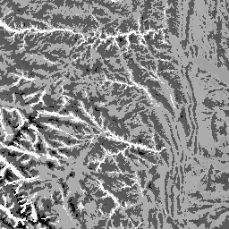
The Physiography dataset combines landform and lithology data layers to represent their spatial intersection, resulting in 247 unique combinations.
-
Each value in the dataset represents a specific combination of landform and lithology type, created by concatenating their respective codes.
-
The landforms layer is derived from the USGS 10m NED DEM, while the lithology layer is not DEM-based.
-
This dataset is currently available only for the United States.
- Dataset Availability
- 2006-01-24T00:00:00Z–2011-05-13T00:00:00Z
- Dataset Producer
- Conservation Science Partners
- Tags
Description
The Physiography dataset represents the spatial intersection of landforms (available in EE as ERGo/1_0/US/landforms) and lithology (available in EE as ERGo/1_0/US/lithology) data layers. It provides 247 unique combinations out of a possible 270. The values for each type are formed by concatenating the landform and lithology types (e.g., 1101 is "Peak/ridge" landform on "carbonate" lithology). This data layer is sometimes referred to as characterizing "land facets".
The landforms layer is based on the USGS's 10m NED DEM (available in EE as USGS/NED). The lithology layer is not basen on any DEM.
This dataset is provided just for the US, because of the availability of the lithology data layer, though these data are likely available for other countries.
Bands
Bands
Pixel size: 90 meters (all bands)
| Name | Min | Max | Pixel Size | Description |
|---|---|---|---|---|
constant |
1100 | 4220 | 90 meters | Landforms and lithology intersection |
Terms of Use
Terms of Use
Citations
Theobald, D. M., Harrison-Atlas, D., Monahan, W. B., & Albano, C. M. (2015). Ecologically-relevant maps of landforms and physiographic diversity for climate adaptation planning. PloS one, 10(12), e0143619
Explore with Earth Engine
Code Editor (JavaScript)
var dataset = ee.Image('CSP/ERGo/1_0/US/physiography');
var physiography = dataset.select('constant');
var physiographyVis = {
  min: 1100.0,
  max: 4220.0,
};
Map.setCenter(-105.4248, 40.5242, 8);
Map.addLayer(physiography, physiographyVis, 'Physiography');