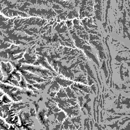
지형 데이터 세트는 지형(EE에서 ERGo/1_0/US/landforms로 제공)과 암석 (EE에서 ERGo/1_0/US/lithology로 제공) 데이터 레이어의 공간 교차를 나타냅니다. 가능한 270개 중 247개의 고유한 조합을 제공합니다. 각 유형의 값은 지형 및 암석 유형을 연결하여 형성됩니다 (예: 1101은 '탄산염' 암석의 '봉우리/능선' 지형입니다. 이 데이터 레이어를 '지형 패싯'이라고도 합니다.
지형 레이어는 USGS의 10m NED DEM (EE에서 USGS/NED로 사용 가능)을 기반으로 합니다. 암석학 레이어는 DEM을 기반으로 하지 않습니다.
이 데이터 세트는 암석학 데이터 레이어의 가용성으로 인해 미국에만 제공되지만, 이 데이터는 다른 국가에서도 사용할 수 있습니다.
지형 데이터 세트는 지형 (EE에서 ERGo/1_0/US/landforms로 제공)과 암석 (EE에서 ERGo/1_0/US/lithology로 제공) 데이터 레이어의 공간 교차를 나타냅니다. 가능한 270개 조합 중 247개의 고유한 조합을 제공합니다. 각 유형의 값은 지형 및 암석 유형을 연결하여 형성됩니다 (예: 1101은 …
[null,null,[],[[["\u003cp\u003eThe Physiography dataset for the US combines landform and lithology data, resulting in 247 unique land facet classifications.\u003c/p\u003e\n"],["\u003cp\u003eThis dataset is derived from the USGS 10m NED DEM for landforms and a separate lithology layer, offering a 90-meter resolution.\u003c/p\u003e\n"],["\u003cp\u003eLand facet classifications are represented by concatenating landform and lithology type values (e.g., 1101 signifies "Peak/ridge" landform on "carbonate" lithology).\u003c/p\u003e\n"],["\u003cp\u003eThe dataset is available for the US and is provided by Conservation Science Partners under a CC-BY-NC-SA-4.0 license.\u003c/p\u003e\n"],["\u003cp\u003eUsers can access and analyze this dataset within the Google Earth Engine platform using provided code snippets.\u003c/p\u003e\n"]]],[],null,["# US Physiography\n\nDataset Availability\n: 2006-01-24T00:00:00Z--2011-05-13T00:00:00Z\n\nDataset Provider\n:\n\n\n [Conservation Science Partners](https://www.csp-inc.org/)\n\nTags\n:\n[aspect](/earth-engine/datasets/tags/aspect) [csp](/earth-engine/datasets/tags/csp) [elevation](/earth-engine/datasets/tags/elevation) [elevation-topography](/earth-engine/datasets/tags/elevation-topography) [ergo](/earth-engine/datasets/tags/ergo) [geophysical](/earth-engine/datasets/tags/geophysical) [landforms](/earth-engine/datasets/tags/landforms) [slope](/earth-engine/datasets/tags/slope) [topography](/earth-engine/datasets/tags/topography) [us](/earth-engine/datasets/tags/us) \n\n#### Description\n\nThe Physiography dataset represents the spatial intersection of landforms\n(available in EE as ERGo/1_0/US/landforms) and lithology (available in EE\nas ERGo/1_0/US/lithology) data layers. It provides 247 unique combinations\nout of a possible 270. The values for each type are formed by concatenating\nthe landform and lithology types (e.g., 1101 is \"Peak/ridge\" landform on\n\"carbonate\" lithology). This data layer is sometimes referred to as\ncharacterizing \"land facets\".\n\nThe landforms layer is based on the USGS's 10m NED DEM (available in EE\nas USGS/NED). The lithology layer is not basen on any DEM.\n\nThis dataset is provided just for the US, because of the availability\nof the lithology data layer, though these data are likely available for\nother countries.\n\n### Bands\n\n\n**Pixel Size**\n\n90 meters\n\n**Bands**\n\n| Name | Min | Max | Pixel Size | Description |\n|------------|------|------|------------|--------------------------------------|\n| `constant` | 1100 | 4220 | meters | Landforms and lithology intersection |\n\n### Terms of Use\n\n**Terms of Use**\n\n[CC-BY-NC-SA-4.0](https://spdx.org/licenses/CC-BY-NC-SA-4.0.html)\n\n### Citations\n\nCitations:\n\n- Theobald, D. M., Harrison-Atlas, D., Monahan, W. B., \\& Albano, C. M.\n (2015). Ecologically-relevant maps of landforms and physiographic diversity\n for climate adaptation planning. PloS one, 10(12),\n [e0143619](https://journals.plos.org/plosone/article?id=10.1371/journal.pone.0143619)\n\n### Explore with Earth Engine\n\n| **Important:** Earth Engine is a platform for petabyte-scale scientific analysis and visualization of geospatial datasets, both for public benefit and for business and government users. Earth Engine is free to use for research, education, and nonprofit use. To get started, please [register for Earth Engine access.](https://console.cloud.google.com/earth-engine)\n\n### Code Editor (JavaScript)\n\n```javascript\nvar dataset = ee.Image('CSP/ERGo/1_0/US/physiography');\nvar physiography = dataset.select('constant');\nvar physiographyVis = {\n min: 1100.0,\n max: 4220.0,\n};\nMap.setCenter(-105.4248, 40.5242, 8);\nMap.addLayer(physiography, physiographyVis, 'Physiography');\n```\n[Open in Code Editor](https://code.earthengine.google.com/?scriptPath=Examples:Datasets/CSP/CSP_ERGo_1_0_US_physiography) \n[US Physiography](/earth-engine/datasets/catalog/CSP_ERGo_1_0_US_physiography) \nThe Physiography dataset represents the spatial intersection of landforms (available in EE as ERGo/1_0/US/landforms) and lithology (available in EE as ERGo/1_0/US/lithology) data layers. It provides 247 unique combinations out of a possible 270. The values for each type are formed by concatenating the landform and lithology types (e.g., 1101 is ... \nCSP/ERGo/1_0/US/physiography, aspect,csp,elevation,elevation-topography,ergo,geophysical,landforms,slope,topography,us \n2006-01-24T00:00:00Z/2011-05-13T00:00:00Z \n12.54 -132.09 56.21 -60.35 \nGoogle Earth Engine \nhttps://developers.google.com/earth-engine/datasets\n\n- [](https://doi.org/https://www.csp-inc.org/)\n- [](https://doi.org/https://developers.google.com/earth-engine/datasets/catalog/CSP_ERGo_1_0_US_physiography)"]]