Cet ensemble de données contient des prévisions à 15 jours des champs du modèle de vagues générés par le système de prévision intégré (IFS) du CEPMMT à une résolution de 0,25 degré. Nous les appelons "quasi temps réel" (NRT, Near-Realtime) car de nouveaux produits sont publiés deux fois par jour après la publication des données de prévision en temps réel de l'ECMWF, dont il s'agit d'un sous-ensemble. Les données peuvent être distribuées et utilisées à des fins commerciales avec attribution appropriée.
Les produits sont disponibles dans Earth Engine à partir de l'implémentation du cycle 49r1 le 12 novembre 2024. Les produits antérieurs ne sont pas inclus. Pour obtenir des informations générales sur l'utilisation des ensembles de données ECMWF NRT, consultez leur documentation utilisateur.
Les fichiers sources sont disponibles sur Google Cloud Marketplace.
Bracelets
Taille des pixels 28 000 mètres
Bandes de fréquences
Nom
Unités
Min
Max
Taille des pixels
Description
mean_zero_crossing_wave_period_sfc
secondes
0,889358*
17,0074*
mètres
Durée moyenne entre les occasions où la surface de la mer/de l'océan franchit le niveau moyen de la mer.
Hauteur moyenne du tiers supérieur des vagues de surface de l'océan/de la mer générées par le vent et la houle. Elle représente la distance verticale entre la crête et le creux de la vague.
mean_wave_direction_sfc
deg
0
360
mètres
Direction moyenne des vagues de surface de l'océan/de la mer par rapport à l'emplacement géographique du pôle Nord (par exemple, 0 signifie "venant du nord" et 90 signifie "venant de l'est").
peak_wave_period_sfc
secondes
1.03074*
23.9353*
mètres
Période des vagues océaniques les plus énergiques générées par les vents locaux et associées à la houle. La période de la houle correspond au temps moyen nécessaire pour que deux crêtes de vagues consécutives à la surface de l'océan/de la mer passent par un point fixe.
mean_wave_period_sfc
secondes
1.04071*
19,5239*
mètres
Temps moyen nécessaire pour que deux crêtes de vagues consécutives passent par un point fixe à la surface de l'océan ou de la mer.
* valeur minimale ou maximale estimée
Propriétés des images
Propriétés de l'image
Nom
Type
Description
creation_day
INT
Jour du mois où la prévision a été créée.
creation_doy
INT
Jour de l'année où la prévision a été créée.
creation_hour
INT
Heure de la journée à laquelle la prévision a été créée.
creation_month
INT
Mois de l'année où la prévision a été créée.
creation_time
INT
Heure de création de la prévision, en millisecondes depuis l'epoch Unix.
creation_year
INT
Année de création de la prévision.
forecast_hours
INT
Nombre d'heures dans le futur, par rapport à creation_time, pour la prévision.
forecast_time
INT
Heure de la prévision, en millisecondes depuis l'epoch Unix.
modèle
STRING
Le modèle de prévision de l'ECMWF :
ifs : Integrated Forecasting System
aifs : Artificial Intelligence/Integrated Forecasting System (Intelligence artificielle/Système de prévision intégré)
flux
STRING
Flux à partir duquel les variables ont été récupérées. Pour consulter la liste complète, cliquez ici.
Cet ensemble de données contient des prévisions à 15 jours des champs du modèle de vagues générés par le système de prévision intégré (IFS) du CEPMMT à une résolution de 0,25 degré. Nous les appelons "quasi temps réel" (NRT, Near-Realtime) car de nouveaux produits sont publiés deux fois par jour après la publication des données de prévision en temps réel du CEPMMT, dont …
[null,null,[],[],[],null,["Dataset Availability\n: 2024-11-12T12:00:00Z--2025-09-06T00:00:00Z\n\nDataset Provider\n:\n\n\n [ECMWF](https://www.ecmwf.int/en/forecasts/datasets/open-data)\n\nCadence\n: 12 Hours\n\nTags\n:\n[climate](/earth-engine/datasets/tags/climate) [ecmwf](/earth-engine/datasets/tags/ecmwf) [forecast](/earth-engine/datasets/tags/forecast) [global](/earth-engine/datasets/tags/global) [ocean](/earth-engine/datasets/tags/ocean) \n\nDescription \nThis dataset contains 15-day forecasts of the wave model fields\ngenerated by the ECMWF Integrated Forecasting System (IFS) at 0.25 degree\nresolution. We refer to these as Near-Realtime (NRT) because new products\nare released twice a day after the release of the ECMWF realtime forecast\ndata, of which this is a subset. Data may be distributed and used\ncommercially with\n[proper attribution](https://apps.ecmwf.int/datasets/licences/general/).\n\nProducts are available in Earth Engine starting with the implementation of\n[Cycle 49r1](https://confluence.ecmwf.int/display/FCST/Implementation+of+IFS+Cycle+49r1)\non 2024-11-12; earlier products are not included. For general information\nabout how to use ECMWF NRT datasets, see their\n[user documentation](https://confluence.ecmwf.int/display/DAC/ECMWF+open+data%3A+real-time+forecasts+from+IFS+and+AIFS).\nSources files are available in the\n[Google Cloud marketplace](https://console.cloud.google.com/marketplace/product/bigquery-public-data/open-data-ecmwf).\n\nBands\n\n\n**Pixel Size**\n\n28000 meters\n\n**Bands**\n\n| Name | Units | Min | Max | Pixel Size | Description |\n|-----------------------------------------------------------|---------|-------------|-----------|------------|------------------------------------------------------------------------------------------------------------------------------------------------------------------------------------------------------------------------------------------------|\n| `mean_zero_crossing_wave_period_sfc` | seconds | 0.889358\\* | 17.0074\\* | meters | The mean length of time between occasions where the sea/ocean surface crosses mean sea level. |\n| `significant_height_of_combined_wind_waves_and_swell_sfc` | m | 0.0172079\\* | 15.7469\\* | meters | The average height of the highest third of surface ocean/sea waves generated by wind and swell. It represents the vertical distance between the wave crest and the wave trough. |\n| `mean_wave_direction_sfc` | deg | 0 | 360 | meters | The mean direction of ocean/sea surface waves relative to the geographic location of the north pole (e.g., 0 means \"coming from the north\" and 90 \"coming from the east\"). |\n| `peak_wave_period_sfc` | seconds | 1.03074\\* | 23.9353\\* | meters | The period of the most energetic ocean waves generated by local winds and associated with swell. The wave period is the average time it takes for two consecutive wave crests, on the surface of the ocean/sea, to pass through a fixed point. |\n| `mean_wave_period_sfc` | seconds | 1.04071\\* | 19.5239\\* | meters | The average time it takes for two consecutive wave crests, on the surface of the ocean/sea, to pass through a fixed point. |\n\n\\* estimated min or max value\n\nImage Properties\n\n**Image Properties**\n\n| Name | Type | Description |\n|----------------|--------|---------------------------------------------------------------------------------------------------------------------------------|\n| creation_day | INT | Day of the month when the forecast was created. |\n| creation_doy | INT | Day of the year when the forecast was created. |\n| creation_hour | INT | Hour of the day when the forecast was created. |\n| creation_month | INT | Month of the year when the forecast was created. |\n| creation_time | INT | Time, in unix epoch milliseconds, when forecast was created. |\n| creation_year | INT | Year when the forecast was created. |\n| forecast_hours | INT | Hours into the future, relative to `creation_time`, of the forecast. |\n| forecast_time | INT | Time, in unix epoch milliseconds, of the forecast. |\n| model | STRING | The ECMWF forecasting model: - ifs: Integrated Forecasting System - aifs: Artificial Intelligence/Integrated Forecasting System |\n| stream | STRING | The stream from which the variables were fetched. See the full list [here](https://codes.ecmwf.int/grib/format/mars/stream/). |\n\nTerms of Use\n\n**Terms of Use**\n\n[CC-BY-4.0](https://spdx.org/licenses/CC-BY-4.0.html)\n\nDOIs\n\n- \u003chttps://doi.org/10.21957/open-data\u003e\n\nExplore with Earth Engine **Important:** Earth Engine is a platform for petabyte-scale scientific analysis and visualization of geospatial datasets, both for public benefit and for business and government users. Earth Engine is free to use for research, education, and nonprofit use. To get started, please [register for Earth Engine access.](https://console.cloud.google.com/earth-engine)\n\nCode Editor (JavaScript) \n\n```javascript\n
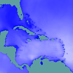
// Observe the ocean in the vicinity of the Caribbean islands and\n// Gulf coast.\nvar aoi = ee.Geometry.Polygon(\n [[\n [-100.6052734375, 31.751243295508836],\n [-100.6052734375, 6.080143483787566],\n [-57.18730468750001, 6.080143483787566],\n [-57.18730468750001, 31.751243295508836]\n ]],\n null, false);\n\n// Extract significant wave height forecasts made at noon on 2025/6/11.\nvar wave =\n ee.ImageCollection('ECMWF/NRT_FORECAST/IFS/WAVE')\n .filter(ee.Filter.eq('creation_doy', 162))\n .filter(ee.Filter.eq('creation_hour', 12))\n .sort('forecast_hours')\n .select('significant_height_of_combined_wind_waves_and_swell_sfc');\n\n// Display the observations at forecast hour 0 on the map.\nvar hour0 = wave.first().clip(aoi);\nMap.centerObject(hour0);\nMap.addLayer(hour0, {min: 0, max: 5}, 'sig height fc=0');\n\n// Animate the wave height forecasts over time.\nvar videoArgs = {\n dimensions: 540,\n region: aoi,\n framesPerSecond: 7,\n crs: 'EPSG:3857',\n min: 0,\n max: 5,\n};\nprint(ui.Thumbnail(wave, videoArgs));\n```\n[Open in Code Editor](https://code.earthengine.google.com/?scriptPath=Examples:Datasets/ECMWF/ECMWF_NRT_FORECAST_IFS_WAVE) \n[ECMWF Near-Realtime IFS Wave Forecasts](/earth-engine/datasets/catalog/ECMWF_NRT_FORECAST_IFS_WAVE) \nThis dataset contains 15-day forecasts of the wave model fields generated by the ECMWF Integrated Forecasting System (IFS) at 0.25 degree resolution. We refer to these as Near-Realtime (NRT) because new products are released twice a day after the release of the ECMWF realtime forecast data, of which this is ... \nECMWF/NRT_FORECAST/IFS/WAVE, climate,ecmwf,forecast,global,ocean \n2024-11-12T12:00:00Z/2025-09-06T00:00:00Z \n-90 -180 90 180 \nGoogle Earth Engine \nhttps://developers.google.com/earth-engine/datasets\n\n- [https://doi.org/10.21957/open-data](https://doi.org/https://www.ecmwf.int/en/forecasts/datasets/open-data)\n- [https://doi.org/10.21957/open-data](https://doi.org/https://developers.google.com/earth-engine/datasets/catalog/ECMWF_NRT_FORECAST_IFS_WAVE)"]]