- 数据集可用时间
- 2018-01-01T00:00:00Z–2026-07-11T00:00:00Z
- 数据集生产者
- FAO UN
- 频率
- 10 天
- 标签
说明
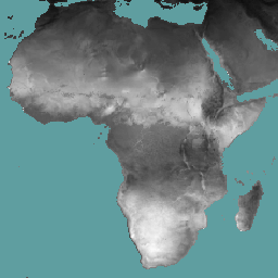
参考蒸散量 (RET) 是指假设的参考作物的蒸散量,它模拟了水分充足的草地表面的行为。每个像素的值表示相应旬的日参考蒸散量的平均值。
频段
波段
像素大小:18,924 米(所有波段)
| 名称 | 单位 | 扩缩 | 像素尺寸 | 说明 |
|---|---|---|---|---|
L1-RET-D |
mm | 0.1 | 18924 米 | 参考蒸散量(旬)[毫米] |
使用条款
使用条款
联合国粮食及农业组织 (FAO) 的任务是收集、分析、解读和传播与营养、粮食和农业相关的信息。为此,粮农组织发布了许多与自身职责相关的主题数据库,并鼓励将这些数据库用于科学和研究目的。根据统计数据库开放数据许可中设想的开放和共享原则,并根据粮农组织的授权,水生产力开放获取门户 (WaPOR) 的数据(作为 AQUASTAT 的一部分,即粮农组织关于水和农业的全球信息系统)可供用户群体免费使用。
引用
引用:
FAO 2018 年。WaPOR 数据库方法:级别 1。Remote Sensing for Water
Productivity Technical Report: Methodology Series. 罗马,粮农组织。72 页。FAO,2020 年。WaPOR V2 数据库方法。Remote Sensing for Water Productivity Technical Report: Methodology Series. 罗马,粮农组织。https://www.fao.org/3/ca9894en/CA9894EN.pdf
通过 Earth Engine 探索
代码编辑器 (JavaScript)
var coll = ee.ImageCollection('FAO/WAPOR/3/L1_RET_D');
var image = coll.first();
Map.setCenter(17.5, 20, 3);
Map.addLayer(image, {min: 0, max: 100});