Earth Engine 버전의 Fire Information for Resource Management System (FIRMS) 데이터 세트에는 래스터화된 형태의 LANCE 화재 감지 제품이 포함되어 있습니다. 거의 실시간 (NRT) 활성 화재 위치는 표준 MODIS MOD14/MYD14 화재 및 열 이상 제품을 사용하여 LANCE에서 처리합니다. 각 활성 화재 위치는 알고리즘에서 픽셀 내에 하나 이상의 화재가 포함된 것으로 표시한 1km 픽셀의 중심을 나타냅니다. 데이터는 다음과 같이 래스터화됩니다. 각 FIRMS 활성 화재 지점에 대해 1km 경계 상자 (BB)가 정의됩니다. FIRMS BB와 교차하는 MODIS 사인 곡선 투영의 픽셀이 식별됩니다. 여러 FIRMS BB가 동일한 픽셀과 교차하는 경우 신뢰도가 높은 픽셀이 유지됩니다. 동점인 경우 더 밝은 픽셀이 유지됩니다.
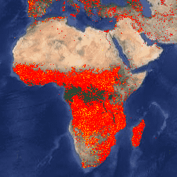
Earth Engine 버전의 Fire Information for Resource Management System (FIRMS) 데이터 세트에는 래스터화된 형식의 LANCE 화재 감지 제품이 포함되어 있습니다. 거의 실시간 (NRT) 활성 화재 위치는 표준 MODIS MOD14/MYD14 화재 및 열 이상 제품을 사용하여 LANCE에서 처리합니다. 각 활성 화재 위치는 다음을 나타냅니다.
[null,null,[],[[["\u003cp\u003eFIRMS provides near real-time (NRT) active fire data, derived from the MODIS MOD14/MYD14 Fire and Thermal Anomalies product and presented in rasterized form.\u003c/p\u003e\n"],["\u003cp\u003eEach active fire location in the dataset represents the centroid of a 1km pixel flagged by the algorithm as containing one or more fires.\u003c/p\u003e\n"],["\u003cp\u003eThe data are considered to be near real-time and not of science quality, with a confidence estimate provided for each fire pixel.\u003c/p\u003e\n"],["\u003cp\u003eThe dataset covers the period from 2000-11-01 to 2024-12-11 and is provided by NASA/LANCE/EOSDIS.\u003c/p\u003e\n"],["\u003cp\u003eVIIRS FIRMS datasets from NOAA20 and SUOMI are also available as separate datasets within the Earth Engine catalog.\u003c/p\u003e\n"]]],["The Fire Information for Resource Management System (FIRMS) dataset, provided by NASA/LANCE/EOSDIS, contains near real-time active fire locations from 2000-11-01 to 2025-02-22. These fire locations, detected using MODIS data, are rasterized as 1km pixels, with higher confidence and brighter pixels prioritized when multiple fire points overlap. The dataset, accessible via Earth Engine using `ee.ImageCollection(\"FIRMS\")`, includes bands like `T21` (temperature), `confidence` (detection quality), and `line_number` (origin in the data file). The data is not considered science-quality.\n"],null,["Dataset Availability\n: 2000-11-01T00:00:00Z--2025-09-03T00:00:00Z\n\nDataset Provider\n:\n\n\n [NASA / LANCE / EOSDIS](https://earthdata.nasa.gov/earth-observation-data/near-real-time/firms)\n\nCadence\n: 1 Day\n\nTags\n:\n[eosdis](/earth-engine/datasets/tags/eosdis) [fire](/earth-engine/datasets/tags/fire) [firms](/earth-engine/datasets/tags/firms) [geophysical](/earth-engine/datasets/tags/geophysical) [hotspot](/earth-engine/datasets/tags/hotspot) [lance](/earth-engine/datasets/tags/lance) [modis](/earth-engine/datasets/tags/modis) [nasa](/earth-engine/datasets/tags/nasa) [thermal](/earth-engine/datasets/tags/thermal) \n\nDescription \nThe Earth Engine version of the Fire Information for Resource Management\nSystem (FIRMS) dataset contains the LANCE fire detection product in\nrasterized form. The near real-time (NRT) active fire locations are\nprocessed by LANCE using the standard MODIS MOD14/MYD14 Fire and Thermal\nAnomalies product. Each active fire location represents the centroid of a\n1km pixel that is flagged by the algorithm as containing one or more fires\nwithin the pixel. The data are rasterized as follows: for each FIRMS active\nfire point, a 1km bounding box (BB) is defined; pixels in the MODIS\nsinusoidal projection that intersect the FIRMS BB are identified; if\nmultiple FIRMS BBs intersect the same pixel, the one with higher confidence\nis retained; in case of a tie, the brighter one is retained.\n\nThe data in the near-real-time dataset are not considered to be of science\nquality.\n\nAdditional information can be found [here](https://firms.modaps.eosdis.nasa.gov/).\n\nNOTE: VIIRS FIRMS datasets from NOAA20 and SUOMI are also available:\n\n- [NASA/LANCE/NOAA20_VIIRS/C2](/earth-engine/datasets/catalog/NASA_LANCE_NOAA20_VIIRS_C2)\n- [NASA/LANCE/SNPP_VIIRS/C2](/earth-engine/datasets/catalog/NASA_LANCE_SNPP_VIIRS_C2)\n\nBands\n\n\n**Pixel Size**\n\n1000 meters\n\n**Bands**\n\n| Name | Units | Min | Max | Pixel Size | Description |\n|---------------|-------|-------|----------|------------|-----------------------------------------------------------------------------------------------------------------------------------------------------------------------------------------------------------------------------------------------------------------------------------------------------------------------------|\n| `T21` | K | 300\\* | 509.29\\* | meters | The brightness temperature of a fire pixel using MODIS channels 21/22. |\n| `confidence` | % | 0 | 100 | meters | A detection confidence intended to help users gauge the quality of individual active fire pixels. The confidence estimate ranges between 0% and 100% for all fire pixels within the fire mask. The confidence field should be used with caution; it is likely that it will vary in meaning in different parts of the world. |\n| `line_number` | | 1\\* | 35302\\* | meters | Line number in the FIRMS CSV file that the pixel came from. |\n\n\\* estimated min or max value\n\nTerms of Use\n\n**Terms of Use**\n\nNASA promotes the full and open sharing of all data with the research and\napplications communities, private industry, academia, and the general\npublic. Read the [NASA Data and Information Policy](https://www.earthdata.nasa.gov/learn/use-data/data-use-policy).\n\nIf you provide the\n[Land, Atmosphere Near real-time Capability for EOS (LANCE) / Fire Information for Resource Management System (FIRMS)](https://earthdata.nasa.gov/earth-observation-data/near-real-time)\ndata to a third party, follow the guidelines in the\n[LANCE Citation, Acknowledgements, and Disclaimer](https://earthdata.nasa.gov/earth-observation-data/near-real-time/citation#ed-lance-disclaimer)\nsite and replicate or provide a link to the\n[disclaimer](https://earthdata.nasa.gov/earth-observation-data/near-real-time/citation#ed-lance-disclaimer).\n\nCitations \nCitations:\n\n- MODIS Collection 6 NRT Hotspot / Active Fire Detections MCD14DL.\n Available on-line \u003chttps://earthdata.nasa.gov/firms\u003e.\n [doi:10.5067/FIRMS/MODIS/MCD14DL.NRT.006](https://doi.org/10.5067/FIRMS/MODIS/MCD14DL.NRT.006)\n\nExplore with Earth Engine **Important:** Earth Engine is a platform for petabyte-scale scientific analysis and visualization of geospatial datasets, both for public benefit and for business and government users. Earth Engine is free to use for research, education, and nonprofit use. To get started, please [register for Earth Engine access.](https://console.cloud.google.com/earth-engine)\n\nCode Editor (JavaScript) \n\n```javascript\nvar dataset = ee.ImageCollection('FIRMS').filter(\n ee.Filter.date('2018-08-01', '2018-08-10'));\nvar fires = dataset.select('T21');\nvar firesVis = {\n min: 325.0,\n max: 400.0,\n palette: ['red', 'orange', 'yellow'],\n};\nMap.setCenter(-119.086, 47.295, 6);\nMap.addLayer(fires, firesVis, 'Fires');\n```\n[Open in Code Editor](https://code.earthengine.google.com/?scriptPath=Examples:Datasets/FIRMS/FIRMS) \n[FIRMS: Fire Information for Resource Management System](/earth-engine/datasets/catalog/FIRMS) \nThe Earth Engine version of the Fire Information for Resource Management System (FIRMS) dataset contains the LANCE fire detection product in rasterized form. The near real-time (NRT) active fire locations are processed by LANCE using the standard MODIS MOD14/MYD14 Fire and Thermal Anomalies product. Each active fire location represents the ... \nFIRMS, eosdis,fire,firms,geophysical,hotspot,lance,modis,nasa,thermal \n2000-11-01T00:00:00Z/2025-09-03T00:00:00Z \n-90 -180 90 180 \nGoogle Earth Engine \nhttps://developers.google.com/earth-engine/datasets\n\n- [](https://doi.org/https://earthdata.nasa.gov/earth-observation-data/near-real-time/firms)\n- [](https://doi.org/https://developers.google.com/earth-engine/datasets/catalog/FIRMS)"]]