- Disponibilité des ensembles de données
- 2006-01-01T00:00:00Z–2015-06-10T00:00:00Z
- Fournisseur de l'ensemble de données
- Global Forest Watch, World Resources Institute
- Tags
Description
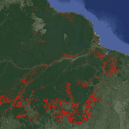
FORMA est un système d'alerte de déforestation basé sur MODIS pour les forêts tropicales humides. FORMA est conçu pour identifier rapidement les nouvelles zones de perte de couverture arborée. Le système analyse les données collectées quotidiennement par le capteur MODIS, qui fonctionne sur les satellites Terra et Aqua de la NASA. Le système d'alertes FORMA détecte ensuite les changements importants de la couverture végétale au fil du temps, tels que mesurés par l'indice de végétation par différence normalisée (NDVI), qui mesure la verdure de la végétation. Ces changements importants de la couverture végétale indiquent probablement que la forêt a été défrichée, brûlée ou défoliée. Une alerte est ajoutée à l'ensemble de données en définissant la valeur du pixel sur la date à laquelle un changement a été détecté. Les alertes FORMA n'apparaissent que dans les zones où la probabilité de perte de couverture forestière est supérieure ou égale à 50 %. Les données FORMA ont une résolution spatiale de 500 mètres et sont mises à jour deux fois par mois. Les alertes FORMA ont commencé en janvier 2006.
Bracelets
Taille des pixels
500 mètres
Bandes de fréquences
| Nom | Unités | Min | Max | Taille des pixels | Description |
|---|---|---|---|---|---|
constant |
secondes | 1.13498e+09* | 1.43392e+09* | mètres |
Conditions d'utilisation
Conditions d'utilisation
Les ensembles de données FORMA sont disponibles sans restriction d'utilisation ni de distribution. Le WRI demande à l'utilisateur de mentionner correctement la source des données et d'identifier le WRI et GFW, le cas échéant.
Citations
Hammer, Dan, Robin Kraft et David Wheeler. 2013. Alertes FORMA. World Resources Institute and Center for Global Development. www.globalforestwatch.org.
Explorer avec Earth Engine
Éditeur de code (JavaScript)
var dataset = ee.Image('FORMA/FORMA_500m');

var visualization = {
  bands: ['constant'],
  min: 1134979200.0,
  max: 1433919600.0,
  palette: ['ff0000']
};

Map.setCenter(-51.482, -0.835, 6);

Map.addLayer(dataset, visualization, 'Alert Areas');