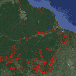
FORMA는 습한 열대 우림을 위한 MODIS 기반 삼림 파괴 알림 시스템입니다. FORMA는 나무 덮개 손실의 새로운 영역을 신속하게 식별하도록 설계되었습니다. 이 시스템은 NASA의 Terra 및 Aqua 위성에서 작동하는 MODIS 센서가 매일 수집하는 데이터를 분석합니다. 그런 다음 FORMA 알림 시스템은 식생의 녹색도를 측정하는 정규 식생 지수 (NDVI)로 측정된 시간에 따른 식생 피복의 뚜렷한 변화를 감지합니다. 식물 피복의 이러한 뚜렷한 변화는 숲이 벌채되거나, 불에 타거나, 낙엽이 지는 것을 나타낼 수 있습니다. 픽셀 값을 변경이 감지된 날짜로 설정하여 데이터 세트에 알림이 추가됩니다. FORMA 알림은 산림 피복 손실 가능성이 50% 이상인 지역에만 표시됩니다. FORMA 데이터는 500미터 공간 해상도와 월 2회 업데이트 간격을 갖습니다. FORMA 알림은 2006년 1월에 시작됩니다.
FORMA는 습한 열대림을 위한 MODIS 기반 삼림 파괴 알림 시스템입니다. FORMA는 새로운 산림 손실 지역을 신속하게 식별하도록 설계되었습니다. 이 시스템은 NASA의 Terra 및 Aqua 위성에서 작동하는 MODIS 센서가 매일 수집하는 데이터를 분석합니다. 그러면 FORMA 알림 시스템에서 뚜렷한 …
[null,null,[],[[["\u003cp\u003eFORMA is a MODIS-based deforestation alerting system for the humid tropical forests designed for quick identification of new areas of tree cover loss.\u003c/p\u003e\n"],["\u003cp\u003eThe system analyzes data from NASA's Terra and Aqua satellites to detect pronounced changes in vegetation cover, indicating potential forest clearing, burning, or defoliation.\u003c/p\u003e\n"],["\u003cp\u003eFORMA alerts are generated for areas with a probability of tree cover loss greater than or equal to 50% and are represented by pixel values corresponding to the date of change detection.\u003c/p\u003e\n"],["\u003cp\u003eThis dataset has been superseded by WRI/GFW/FORMA/alerts and has a spatial resolution of 500 meters with a twice-monthly update interval, covering the period from January 2006 to June 2015.\u003c/p\u003e\n"],["\u003cp\u003eThe FORMA datasets are available without restriction on use or distribution, with proper attribution requested to WRI and GFW as the data source.\u003c/p\u003e\n"]]],["FORMA, a MODIS-based system, identifies new tree cover loss in humid tropical forests by analyzing daily data from NASA's Terra and Aqua satellites. It uses the Normalized Difference Vegetation Index (NDVI) to detect changes indicative of clearing, burning, or defoliation. Alerts, represented by pixel values set to the change detection date, appear where tree cover loss probability is ≥50%. The data, updated twice-monthly, has a 500-meter spatial resolution and covers January 2006 to June 2015. This data is now deprecated.\n"],null,["**Caution:** This dataset has been superseded by [WRI/GFW/FORMA/alerts](/earth-engine/datasets/catalog/WRI_GFW_FORMA_alerts). \n\nDataset Availability\n: 2006-01-01T00:00:00Z--2015-06-10T00:00:00Z\n\nDataset Provider\n:\n\n\n [Global Forest Watch, World Resources Institute](https://www.globalforestwatch.org)\n\nTags\n:\n alerts \n deforestation \n fire \n forest \n forma \n geophysical \n gfw \n modis \n nasa \nwri \n\nDescription \nFORMA is a MODIS-based deforestation alerting system for the humid tropical\nforests. FORMA is designed for quick identification of new areas of tree\ncover loss. The system analyzes data gathered daily by the MODIS sensor,\nwhich operates on NASA's Terra and Aqua satellites. The FORMA alerts system\nthen detects pronounced changes in vegetation cover over time, as measured\nby the Normalized Difference Vegetation Index (NDVI), a measure of\nvegetation greenness. These pronounced changes in vegetation cover are\nlikely to indicate forest being cleared, burned, or defoliated. An alert is\nadded to the dataset by setting the pixel value to the date at which a\nchange was detected. FORMA alerts only appear in areas where the probability\nof tree cover loss is greater than or equal to 50%. FORMA data has 500-meter\nspatial resolution and twice-monthly update interval. FORMA alerts start in\nJanuary 2006.\n\nBands\n\n\n**Pixel Size**\n\n500 meters\n\n**Bands**\n\n| Name | Units | Min | Max | Pixel Size | Description |\n|------------|---------|---------------|---------------|------------|----------------------------------------------------------------------|\n| `constant` | seconds | 1.13498e+09\\* | 1.43392e+09\\* | meters | [Seconds since Jan 1, 1970](https://en.wikipedia.org/wiki/Unix_time) |\n\n\\* estimated min or max value\n\nTerms of Use\n\n**Terms of Use**\n\nThe FORMA datasets are available without restriction on use or distribution.\nWRI does request that the user give proper attribution and identify WRI and\nGFW, where applicable, as the source of the data.\n\nCitations \nCitations:\n\n- Hammer, Dan, Robin Kraft, and David Wheeler. 2013. FORMA Alerts. World\n Resources Institute and Center for Global Development.\n [www.globalforestwatch.org](/earth-engine/datasets/catalog/www.globalforestwatch.org).\n\nExplore with Earth Engine **Important:** Earth Engine is a platform for petabyte-scale scientific analysis and visualization of geospatial datasets, both for public benefit and for business and government users. Earth Engine is free to use for research, education, and nonprofit use. To get started, please [register for Earth Engine access.](https://console.cloud.google.com/earth-engine)\n\nCode Editor (JavaScript) \n\n```javascript\nvar dataset = ee.Image('FORMA/FORMA_500m');\n\nvar visualization = {\n bands: ['constant'],\n min: 1134979200.0,\n max: 1433919600.0,\n palette: ['ff0000']\n};\n\nMap.setCenter(-51.482, -0.835, 6);\n\nMap.addLayer(dataset, visualization, 'Alert Areas');\n```\n[Open in Code Editor](https://code.earthengine.google.com/?scriptPath=Examples:Datasets/FORMA/FORMA_FORMA_500m) \n[FORMA Global Forest Watch Deforestation Alerts, 500m \\[deprecated\\]](/earth-engine/datasets/catalog/FORMA_FORMA_500m) \nFORMA is a MODIS-based deforestation alerting system for the humid tropical forests. FORMA is designed for quick identification of new areas of tree cover loss. The system analyzes data gathered daily by the MODIS sensor, which operates on NASA's Terra and Aqua satellites. The FORMA alerts system then detects pronounced ... \nFORMA/FORMA_500m, alerts,deforestation,fire,forest,forma,geophysical,gfw,modis,nasa,wri \n2006-01-01T00:00:00Z/2015-06-10T00:00:00Z \n-90 -180 90 180 \nGoogle Earth Engine \nhttps://developers.google.com/earth-engine/datasets\n\n- [](https://doi.org/https://www.globalforestwatch.org)\n- [](https://doi.org/https://developers.google.com/earth-engine/datasets/catalog/FORMA_FORMA_500m)"]]