Global Land Ice Measurements from Space (GLIMS) 是一项国际计划,旨在反复调查全球约 20 万条冰川。
该项目旨在创建一份全球全面的陆地冰川清单,包括冰川面积、几何形状、表面速度和雪线海拔高度的测量数据。为了执行这些分析,GLIMS 项目使用卫星数据(主要来自高级星载热发射和反射辐射计 [ASTER] 和 Landsat 增强型专题绘图仪 Plus [ETM+]),以及从地图和航空照片中获取的历史信息。
此数据集中的每个要素都是分析时冰川的多边形边界。一些冰川 ID 在不同时间段内有数百个不同的行。
此数据集是截至 2023 年 6 月 7 日的冰川边界库存快照,包含超过 110 万行数据。
表架构
表架构
名称
类型
说明
分析师
STRING
数据贡献者的姓名
anlys_id
双精度
特定时间的冰川 ID
anlys_time
STRING
分析完成时间
区域
双精度
地图投影平面中冰川的面积(以平方公里为单位)
chief_affl
STRING
区域中心负责人的所属机构
db_area
双精度
与“面积”相同,但由 GLIMS 项目重新计算
geog_area
STRING
区域中心覆盖的地理区域的名称
glac_id
STRING
GLIMS 冰川 ID
glac_name
STRING
冰川名称。约 80% 的行等于“无”
glac_stat
STRING
Glacier 状态,可以是“exists”或“None”
长度
双精度
冰川周长(以米为单位)
line_type
STRING
冰川记录类型,例如冰川的“glac_bound”,或内部岩石、雪线、水文要素等的其他值。
local_id
STRING
贡献机构或区域中心分配的 ID
max_elev
双精度
冰川的最高部分,以米为单位,高于海平面
mean_elev
双精度
冰川的平均海拔高度(以米为单位,高于海平面)
min_elev
双精度
冰川的最低部分,以米为单位,高于海平面
parent_id
STRING
相应冰川的父冰川的 ID
primeclass
双精度
WGMS 冰川分类编号
proc_desc
STRING
对相应记录执行的处理的说明
rc_id
双精度
区域中心使用的 ID
rec_status
STRING
记录状态
release_dt
STRING
发布日期数据,格式为 YYYY-MM-ddTHH:mm:ss
src_date
STRING
用于创建轮廓的源影像的日期
subm_id
双精度
由 GLIMS 分配的提交内容 ID
提交者
STRING
数据提交者的姓名
wgms_id
STRING
世界冰川监测服务 ID
width
双精度
冰川的宽度(以米为单位)
使用条款
使用条款
对于因使用该数据集而创建的任何报告、出版物、新数据集、衍生产品或服务,用户应引用:GLIMS 和 NSIDC(2005 年,2013 年更新):Global Land Ice Measurements from Space 冰川数据库。由国际 GLIMS 社区和美国科罗拉多州博尔德市的国家冰雪数据中心编制并提供,doi:10.7265/N5V98602
[null,null,[],[[["\u003cp\u003e\u003cstrong\u003eCaution:\u003c/strong\u003e This dataset has been replaced by a newer version, GLIMS/20230607.\u003c/p\u003e\n"],["\u003cp\u003eGLIMS is an international project creating a global inventory of glacier boundaries, including measurements of glacier area, geometry, velocity, and snow line elevation.\u003c/p\u003e\n"],["\u003cp\u003eThe dataset comprises over 1,100,000 rows, representing glacier boundaries primarily derived from ASTER and Landsat satellite data.\u003c/p\u003e\n"],["\u003cp\u003eEach feature in the dataset represents a glacier's polygonal boundary at the time of analysis, with attributes like area, elevation, and source imagery date.\u003c/p\u003e\n"],["\u003cp\u003eUsers of this dataset for publications or derived products should cite GLIMS and NSIDC, providing the associated DOI.\u003c/p\u003e\n"]]],[],null,["# GLIMS Current: Global Land Ice Measurements From Space\n\nDataset Availability\n: 1750-01-01T00:00:00Z--2023-06-07T00:00:00Z\n\nDataset Provider\n:\n\n\n [National Snow and Ice Data Center (NSDIC)](https://www.glims.org)\n\nTags\n:\n[cryosphere](/earth-engine/datasets/tags/cryosphere) [glacier](/earth-engine/datasets/tags/glacier) [glims](/earth-engine/datasets/tags/glims) [ice](/earth-engine/datasets/tags/ice) [landcover](/earth-engine/datasets/tags/landcover) [nasa](/earth-engine/datasets/tags/nasa) [nsidc](/earth-engine/datasets/tags/nsidc) [snow](/earth-engine/datasets/tags/snow) [table](/earth-engine/datasets/tags/table) \n\n#### Description\n\nGlobal Land Ice Measurements from Space (GLIMS) is\nan international initiative with the goal of repeatedly surveying\nthe world's estimated 200,000 glaciers.\n\nThe project seeks\nto create a globally comprehensive inventory of land ice, including\nmeasurements of glacier area, geometry, surface velocity, and\nsnow line elevation. To perform these analyses, the GLIMS project\nuses satellite data, primarily from the Advanced Spaceborne Thermal\nEmission and Reflection Radiometer (ASTER) and the Landsat Enhanced\nThematic Mapper Plus (ETM+), as well as historical information\nderived from maps and aerial photographs.\n\nEach feature in this dataset is a polygonal boundary of a glacier at the\ntime of analysis. A few glacier IDs have hundreds of distinct rows over\ntime.\n\nThis dataset is a snapshot of the inventory of glacier boundaries as of\nJune 7, 2023, providing over 1,100,000 rows.\n\n### Table Schema\n\n**Table Schema**\n\n| Name | Type | Description |\n|------------|--------|--------------------------------------------------------------------------------------------------------------------------|\n| analysts | STRING | Name(s) of data contributor(s) |\n| anlys_id | DOUBLE | ID of a glacier at a particular time |\n| anlys_time | STRING | When the analysis was done |\n| area | DOUBLE | Area of the glacier in the plane of the map projection in square kilometers |\n| chief_affl | STRING | Affiliation of the chief of the regional center |\n| db_area | DOUBLE | Same as 'area', but recomputed by the GLIMS project |\n| geog_area | STRING | Name of geographic region covered by the regional center |\n| glac_id | STRING | The GLIMS glacier ID |\n| glac_name | STRING | The glacier name. \\~80% of the rows equal 'None' |\n| glac_stat | STRING | Glacier status, either 'exists' or 'None' |\n| length | DOUBLE | Length of the glacier perimeter in meters |\n| line_type | STRING | Glacier record type, e.g. 'glac_bound' for glaciers, or other values for internal rocks, snowlines, water features, etc. |\n| local_id | STRING | ID assigned by the contributing institution or regional center |\n| max_elev | DOUBLE | Highest part of the glacier, in meters above sea level |\n| mean_elev | DOUBLE | Mean elevation of the glacier, in meters above sea level |\n| min_elev | DOUBLE | Lowest part of the glacier, in meters above sea level |\n| parent_id | STRING | ID of the glacier that is the parent of this glacier |\n| primeclass | DOUBLE | WGMS glacier classification number |\n| proc_desc | STRING | Description of processing done on this record |\n| rc_id | DOUBLE | ID used by the regional center |\n| rec_status | STRING | Record status |\n| release_dt | STRING | Date data was released, in YYYY-MM-ddTHH:mm:ss format |\n| src_date | STRING | Date of source imagery used to create the outline |\n| subm_id | DOUBLE | The submission ID assigned by GLIMS |\n| submitters | STRING | Name(s) of data submitter(s) |\n| wgms_id | STRING | World Glacier Monitoring Service ID |\n| width | DOUBLE | Width of the glacier in meters |\n\n### Terms of Use\n\n**Terms of Use**\n\nFor the creation of any reports, publications, new\ndata sets, derived products, or services resulting from the data\nset, users should cite: GLIMS and NSIDC (2005, updated 2013): Global\nLand Ice Measurements from Space glacier database. Compiled and\nmade available by the international GLIMS community and the National\nSnow and Ice Data Center, Boulder CO, U.S.A.,\n[doi:10.7265/N5V98602](https://doi.org/10.7265/N5V98602)\n\n### DOIs\n\n- \u003chttps://doi.org/10.7265/N5V98602\u003e\n\n### Explore with Earth Engine\n\n| **Important:** Earth Engine is a platform for petabyte-scale scientific analysis and visualization of geospatial datasets, both for public benefit and for business and government users. Earth Engine is free to use for research, education, and nonprofit use. To get started, please [register for Earth Engine access.](https://console.cloud.google.com/earth-engine)\n\n### Code Editor (JavaScript)\n\n```javascript\n
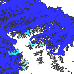
var dataset = ee.FeatureCollection('GLIMS/current');\nvar visParams = {\n palette: ['gray', 'cyan', 'blue'],\n min: 0.0,\n max: 10.0,\n opacity: 0.8,\n};\nvar image = ee.Image().float().paint(dataset, 'area');\nMap.setCenter(-35.618, 66.743, 7);\nMap.addLayer(image, visParams, 'GLIMS/current');\nMap.addLayer(dataset, null, 'for Inspector', false);\n```\n[Open in Code Editor](https://code.earthengine.google.com/?scriptPath=Examples:Datasets/GLIMS/GLIMS_current)\n\n### Visualize as a FeatureView\n\n\nA `FeatureView` is a view-only, accelerated representation of a\n`FeatureCollection`. For more details, visit the\n[`FeatureView` documentation.](/earth-engine/guides/featureview_overview)\n| **Important:** Earth Engine is a platform for petabyte-scale scientific analysis and visualization of geospatial datasets, both for public benefit and for business and government users. Earth Engine is free to use for research, education, and nonprofit use. To get started, please [register for Earth Engine access.](https://console.cloud.google.com/earth-engine)\n\n### Code Editor (JavaScript)\n\n```javascript\nvar fvLayer = ui.Map.FeatureViewLayer('GLIMS/current_FeatureView');\n\nvar visParams = {\n color: {\n property: 'area',\n mode: 'linear',\n palette: ['gray', 'cyan', 'blue'],\n min: 0.0,\n max: 10.0\n },\n opacity: 0.8,\n polygonStrokeOpacity: 0\n};\n\nfvLayer.setVisParams(visParams);\nfvLayer.setName('GLIMS/current');\n\nMap.setCenter(-35.618, 66.743, 7);\nMap.add(fvLayer);\n```\n[Open in Code Editor](https://code.earthengine.google.com/?scriptPath=Examples:Datasets/GLIMS/GLIMS_current_FeatureView) \n[GLIMS Current: Global Land Ice Measurements From Space](/earth-engine/datasets/catalog/GLIMS_current) \nGlobal Land Ice Measurements from Space (GLIMS) is an international initiative with the goal of repeatedly surveying the world's estimated 200,000 glaciers. The project seeks to create a globally comprehensive inventory of land ice, including measurements of glacier area, geometry, surface velocity, and snow line elevation. To perform these analyses, ... \nGLIMS/current, cryosphere,glacier,glims,ice,landcover,nasa,nsidc,snow,table \n1750-01-01T00:00:00Z/2023-06-07T00:00:00Z \n-90 -180 90 180 \nGoogle Earth Engine \nhttps://developers.google.com/earth-engine/datasets\n\n- [https://doi.org/10.7265/N5V98602](https://doi.org/https://www.glims.org)\n- [https://doi.org/10.7265/N5V98602](https://doi.org/https://developers.google.com/earth-engine/datasets/catalog/GLIMS_current)"]]