MACAv2-METDATA 데이터 세트는 미국 본토를 포괄하는 20개의 전역 기후 모델 모음입니다. 다변량 적응형 구성 유사체 (MACA) 방법은 학습 데이터 세트 (즉, 기상 관측 데이터 세트)를 활용하여 과거 편향을 제거하고 기후 모델 출력의 공간 패턴을 일치시키는 통계적 다운스케일링 방법입니다.
MACA 방법은 역사적 GCM 강제력 (1950~2005년)과 미래 대표 농도 경로 (RCP) RCP 4.5 및 RCP 8.5 시나리오 (2006~2100년)에 대해 결합 모델 상호 비교 프로젝트 5 (CMIP5)의 20개 전역 기후 모델 (GCM)에서 모델 출력을 GCM의 기본 해상도에서 4km로 다운스케일하는 데 사용되었습니다.
모델 CCSM4 또는 NorESM1-M에는 표시되지 않는 지표면 근처의 최대 일일 상대 습도
rhsmin
%
1*
100*
미터
모델 CCSM4 또는 NorESM1-M에 표시되지 않는 지표면 근처의 최소 일일 상대 습도
huss
질량 분율
0*
0.05*
미터
지표면 근처의 평균 일일 비습
pr
mm
0*
1609.77*
미터
지표면의 평균 일일 강수량
rsds
W/m^2
9.06*
455.61*
미터
지표면의 평균 일일 하향 단파 복사
uas
m/s
-29.74*
25.96*
미터
지표면 근처의 평균 일일 동쪽 바람 성분
vas
m/s
-29.26*
33.06*
미터
지표면 근처의 평균 일일 북쪽 풍속
* 예상 최솟값 또는 최댓값
이미지 속성
이미지 속성
이름
유형
설명
시나리오
문자열
CMIP5 시나리오의 이름입니다('rcp85', 'rcp45', 'historical' 중 하나).
모델
문자열
CMIP5 모델의 이름입니다(예: 'inmcm4').
앙상블
문자열
'r1i1p1' 또는 'r6i1p1'
이용약관
이용약관
MACA 데이터 세트는 미국 정부의 지원을 받아 생성되었으며 미국에서 공개 도메인에 속합니다.
명확성을 위해 별도로 명시되지 않는 한 MACA 데이터 세트는 크리에이티브 커먼즈 CC0 1.0 범용 헌신으로 제공됩니다.
간단히 말해 John Abatzoglou는 법이 허용하는 범위 내에서 모든 관련 권리 및 인접 권리를 포함하여 저작권법에 따라 전 세계에서 저작물에 대한 모든 권리를 포기합니다. 상업적 목적으로도 허락을 받지 않고 저작물을 복사, 수정, 배포, 실행할 수 있습니다. John Abatzoglou는 저작물에 관해 어떠한 보증도 하지 않으며, 관련 법규에서 허용하는 최대한의 범위 내에서 저작물의 모든 사용에 대한 책임을 부인합니다. 사용자는 이 데이터 세트의 사용으로 생성된 보고서 및 간행물에 사용된 소스를 적절하게 인용하고 데이터가 획득된 날짜를 기록해야 합니다. 자세한 내용은 MACA 참조 및 라이선스 페이지를 참고하세요.
인용
인용:
Abatzoglou J.T. 및 Brown T.J., A comparison of statistical downscaling
methods suited for wildfire applications, International Journal
of Climatology(2012) doi:10.1002/joc.2312.
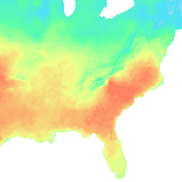
MACAv2-METDATA 데이터 세트는 미국 본토를 포괄하는 20개의 전역 기후 모델 모음입니다. 다변량 적응형 구성 유사체 (MACA) 방법은 학습 데이터 세트 (예: 기상 관측 데이터 세트)를 활용하여 과거 편향을 제거하고 기후 모델 출력의 공간 패턴을 일치시키는 통계적 다운스케일링 방법입니다. …
[null,null,[],[[["\u003cp\u003eMACAv2-METDATA offers downscaled climate data from 20 global climate models for the conterminous US, spanning from 1950 to 2100.\u003c/p\u003e\n"],["\u003cp\u003eIt utilizes the MACA method to enhance the accuracy and spatial patterns of climate model output.\u003c/p\u003e\n"],["\u003cp\u003eThe dataset includes daily maximum/minimum temperature, humidity, precipitation, radiation, and wind data at a 4km resolution.\u003c/p\u003e\n"],["\u003cp\u003eData is available for historical periods (1950-2005) and future RCP 4.5 and RCP 8.5 scenarios (2006-2100).\u003c/p\u003e\n"],["\u003cp\u003eMACAv2-METDATA is publicly available and can be accessed and analyzed using Google Earth Engine.\u003c/p\u003e\n"]]],[],null,["# MACAv2-METDATA: University of Idaho, Multivariate Adaptive Constructed Analogs Applied to Global Climate Models\n\nDataset Availability\n: 1900-01-01T00:00:00Z--2100-12-31T00:00:00Z\n\nDataset Provider\n:\n\n\n [University of California Merced](http://www.climatologylab.org/maca.html)\n\nCadence\n: 1 Day\n\nTags\n:\n[climate](/earth-engine/datasets/tags/climate) [conus](/earth-engine/datasets/tags/conus) [geophysical](/earth-engine/datasets/tags/geophysical) [idaho](/earth-engine/datasets/tags/idaho) [maca](/earth-engine/datasets/tags/maca) [monthly](/earth-engine/datasets/tags/monthly) \n\n#### Description\n\nThe MACAv2-METDATA dataset is a collection of 20 global\nclimate models covering the conterminous USA. The Multivariate Adaptive\nConstructed Analogs (MACA) method is a statistical downscaling\nmethod which utilizes a training dataset (i.e. a meteorological\nobservation dataset) to remove historical biases and match spatial\npatterns in climate model output.\n\nThe MACA method was used to downscale the model output from 20\nglobal climate models (GCMs) of the Coupled Model Inter-Comparison\nProject 5 (CMIP5) for the historical GCM forcings (1950-2005) and\nthe future Representative Concentration Pathways (RCPs) RCP 4.5\nand RCP 8.5 scenarios (2006-2100) from the native resolution of\nthe GCMS to 4km.\n\nThe full list of models can be found at:\n\u003chttps://climate.northwestknowledge.net/MACA/GCMs.php\u003e\n\n### Bands\n\n\n**Pixel Size**\n\n4638.3 meters\n\n**Bands**\n\n| Name | Units | Min | Max | Pixel Size | Description |\n|----------|---------------|----------|-----------|------------|----------------------------------------------------------------------------------------|\n| `tasmax` | K | 222.4\\* | 334.92\\* | meters | Maximum daily temperature near surface |\n| `tasmin` | K | 215.33\\* | 315.61\\* | meters | Minimum daily temperature near surface |\n| `rhsmax` | % | 1\\* | 100\\* | meters | Maximum daily relative humidity near surface, not present in models CCSM4 or NorESM1-M |\n| `rhsmin` | % | 1\\* | 100\\* | meters | Minimum daily relative humidity near surface, not present in models CCSM4 or NorESM1-M |\n| `huss` | Mass fraction | 0\\* | 0.05\\* | meters | Average daily specific humidity near surface |\n| `pr` | mm | 0\\* | 1609.77\\* | meters | Average daily precipitation amount at surface |\n| `rsds` | W/m\\^2 | 9.06\\* | 455.61\\* | meters | Average daily downward shortwave radiation at surface |\n| `uas` | m/s | -29.74\\* | 25.96\\* | meters | Average daily eastward component of wind near surface |\n| `vas` | m/s | -29.26\\* | 33.06\\* | meters | Average daily northward component of wind near surface |\n\n\\* estimated min or max value\n\n### Image Properties\n\n**Image Properties**\n\n| Name | Type | Description |\n|----------|--------|----------------------------------------------------------------------|\n| scenario | STRING | Name of the CMIP5 scenario, one of 'rcp85', 'rcp45', or 'historical' |\n| model | STRING | Name of the CMIP5 model, eg 'inmcm4' |\n| ensemble | STRING | Either 'r1i1p1' or 'r6i1p1' |\n\n### Terms of Use\n\n**Terms of Use**\n\nThe MACA datasets were created with funding from the\nUS government and are in the public domain in the United States.\nFor further clarity, unless otherwise noted, the MACA datasets\nare made available with a Creative Commons CC0 1.0 Universal dedication.\nIn short, John Abatzoglou waives all rights to the work worldwide\nunder copyright law, including all related and neighboring rights,\nto the extent allowed by law. You can copy, modify, distribute,\nand perform the work, even for commercial purposes, all without\nasking permission. John Abatzoglou makes no warranties about the\nwork, and disclaims liability for all uses of the work, to the\nfullest extent permitted by applicable law. Users should properly\ncite the source used in the creation of any reports and publications\nresulting from the use of this dataset and note the date when the\ndata was acquired. For more information refer to the [MACA References\nand License](https://climate.northwestknowledge.net/MACA/MACAreferences.php)\npage.\n\n### Citations\n\nCitations:\n\n- Abatzoglou J.T. and Brown T.J., A comparison of statistical downscaling\n methods suited for wildfire applications, International Journal\n of Climatology(2012) [doi:10.1002/joc.2312](https://doi.org/10.1002/joc.2312).\n\n### Explore with Earth Engine\n\n| **Important:** Earth Engine is a platform for petabyte-scale scientific analysis and visualization of geospatial datasets, both for public benefit and for business and government users. Earth Engine is free to use for research, education, and nonprofit use. To get started, please [register for Earth Engine access.](https://console.cloud.google.com/earth-engine)\n\n### Code Editor (JavaScript)\n\n```javascript\nvar dataset = ee.ImageCollection('IDAHO_EPSCOR/MACAv2_METDATA')\n .filter(ee.Filter.date('2018-08-01', '2018-08-15'));\nvar maximumTemperature = dataset.select('tasmax');\nvar maximumTemperatureVis = {\n min: 290.0,\n max: 314.0,\n palette: ['d8d8d8', '4addff', '5affa3', 'f2ff89', 'ff725c'],\n};\nMap.setCenter(-84.37, 33.5, 5);\nMap.addLayer(maximumTemperature, maximumTemperatureVis, 'Maximum Temperature');\n```\n[Open in Code Editor](https://code.earthengine.google.com/?scriptPath=Examples:Datasets/IDAHO_EPSCOR/IDAHO_EPSCOR_MACAv2_METDATA) \n[MACAv2-METDATA: University of Idaho, Multivariate Adaptive Constructed Analogs Applied to Global Climate Models](/earth-engine/datasets/catalog/IDAHO_EPSCOR_MACAv2_METDATA) \nThe MACAv2-METDATA dataset is a collection of 20 global climate models covering the conterminous USA. The Multivariate Adaptive Constructed Analogs (MACA) method is a statistical downscaling method which utilizes a training dataset (i.e. a meteorological observation dataset) to remove historical biases and match spatial patterns in climate model output. The ... \nIDAHO_EPSCOR/MACAv2_METDATA, climate,conus,geophysical,idaho,maca,monthly \n1900-01-01T00:00:00Z/2100-12-31T00:00:00Z \n24.9 -124.9 49.6 -67 \nGoogle Earth Engine \nhttps://developers.google.com/earth-engine/datasets\n\n- [](https://doi.org/http://www.climatologylab.org/maca.html)\n- [](https://doi.org/https://developers.google.com/earth-engine/datasets/catalog/IDAHO_EPSCOR_MACAv2_METDATA)"]]