- Dataset-Verfügbarkeit
- 1900-01-01T00:00:00Z–2099-12-31T00:00:00Z
- Dataset-Anbieter
- University of California Merced
- Cadence
- 1 Monat
- Tags
Beschreibung
Der Datensatz „MACAv2-METDATA“ umfasst 20 globale Klimamodelle für die kontinentalen USA. Die MACA-Methode (Multivariate Adaptive Constructed Analogs) ist eine statistische Downscaling-Methode, bei der ein Trainings-Dataset (d.h. ein meteorologisches Beobachtungs-Dataset) verwendet wird, um historische Verzerrungen zu entfernen und räumliche Muster in der Ausgabe von Klimamodellen abzugleichen.
Die MACA-Methode wurde verwendet, um die Modellausgabe von 20 globalen Klimamodellen (GCMs) des Coupled Model Inter-Comparison Project 5 (CMIP5) für die historischen GCM-Forcings (1950–2005) und die zukünftigen Representative Concentration Pathways (RCPs) RCP 4.5 und RCP 8.5 (2006–2100) von der nativen Auflösung der GCMs auf 4 km herunterzuskalieren.
Diese Version enthält monatliche Zusammenfassungen.
Die vollständige Liste der Modelle finden Sie unter https://climate.northwestknowledge.net/MACA/GCMs.php.
Bänder
Pixelgröße
4638,3 Meter
Bänder
| Name | Einheiten | Min. | Max. | Pixelgröße | Beschreibung |
|---|---|---|---|---|---|
tasmax |
K | 251,95* | 330,64* | Meter | Monatlicher Durchschnitt der maximalen täglichen Temperatur in Bodennähe |
tasmin |
K | 239,47* | 316.2* | Meter | Monatlicher Durchschnitt der täglichen Mindesttemperatur in Bodennähe |
huss |
Massenanteil | 0* | 0,03* | Meter | Monatlicher Durchschnitt der mittleren täglichen spezifischen Luftfeuchtigkeit in Bodennähe |
pr |
mm | 0* | 3691,91* | Meter | Gesamte monatliche Niederschlagsmenge an der Oberfläche |
rsds |
W/m^2 | 15,84* | 419* | Meter | Monatlicher Durchschnitt der mittleren täglichen kurzwelligen Strahlung an der Erdoberfläche |
was |
m/s | 0,23* | 14.16* | Meter | Monatlicher Durchschnitt der mittleren täglichen Windgeschwindigkeit in Bodennähe |
Bildattribute
Bildattribute
| Name | Typ | Beschreibung |
|---|---|---|
| scenario | STRING | Name des CMIP5-Szenarios, entweder „rcp85“, „rcp45“ oder „historical“ |
| Modell | STRING | Name des CMIP5-Modells, z. B. „inmcm4“ |
| Ensemble | STRING | Entweder „r1i1p1“ oder „r6i1p1“ |
| Monat | DOUBLE | Der Index des Monats im Jahr, d. h. 1–12 |
Nutzungsbedingungen
Nutzungsbedingungen
Die MACA-Datasets wurden mit Mitteln der US-Regierung erstellt und sind in den USA gemeinfrei. Zur weiteren Klarstellung: Sofern nicht anders angegeben, werden die MACA-Datasets mit einer Creative Commons CC0 1.0 Universal-Widmung zur Verfügung gestellt. Kurz gesagt verzichtet John Abatzoglou weltweit auf alle Rechte an dem Werk, die durch das Urheberrecht geschützt sind, einschließlich aller damit verbundenen und benachbarten Rechte, soweit dies gesetzlich zulässig ist. Dieses Werk darf ohne Genehmigung auch für kommerzielle Zwecke kopiert, bearbeitet, verbreitet und aufgeführt werden. John Abatzoglou übernimmt keine Gewährleistung für die Arbeit und schließt die Haftung für alle Verwendungen der Arbeit im größtmöglichen Umfang aus, der nach anwendbarem Recht zulässig ist. Nutzer sollten die Quelle, die bei der Erstellung von Berichten und Publikationen verwendet wurde, die aus der Nutzung dieses Datasets resultieren, ordnungsgemäß angeben und das Datum der Datenerhebung vermerken. Weitere Informationen finden Sie auf der Seite MACA References and License (MACA-Referenzen und ‑Lizenz).
Zitate
Abatzoglou J.T. und Brown T.J., A comparison of statistical downscaling methods suited for wildfire applications, International Journal of Climatology(2012) doi:10.1002/joc.2312.
Earth Engine nutzen
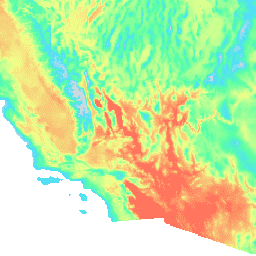
Code-Editor (JavaScript)
var dataset = ee.ImageCollection('IDAHO_EPSCOR/MACAv2_METDATA_MONTHLY')
                  .filter(ee.Filter.date('2018-07-01', '2018-08-01'));
var maximumTemperature = dataset.select('tasmax');
var maximumTemperatureVis = {
  min: 290.0,
  max: 314.0,
  palette: ['d8d8d8', '4addff', '5affa3', 'f2ff89', 'ff725c'],
};
Map.setCenter(-115.356, 38.686, 5);
Map.addLayer(maximumTemperature, maximumTemperatureVis, 'Maximum Temperature');