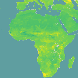
표준 깊이 6개(0~5cm, 5~15cm, 15~30cm, 30~60cm, 60~100cm, 100~200cm)에서 10kPa, 33kPa, 1500kPa 흡인 시의 체적 수분 함량(10^-3 cm^3/cm^3(0.1v% 또는 1mm/m)) 예측은 토양 프로필 데이터와 환경 레이어의 전역 컴파일을 기반으로 하는 분위수 랜덤 포레스트를 기반으로 하는 디지털 토양 매핑 접근 방식을 사용하여 도출되었습니다.
이 데이터 세트에는 세 가지 다른 흡입 수준에 대한 예측이 포함되어 있어 토양 수분 가용성에 대한 유용한 정보를 제공합니다.
데이터 세트는 /wv0010, /wv0033, /wv1500의 세 가지 기본 애셋으로 구성됩니다. 이러한 각 애셋에는 다양한 깊이와 분위수를 나타내는 토양 속성이 포함되어 있습니다. 대역 이름은 val_<depth>_<quantile> 패턴을 따릅니다. 여기서 depth은 토양 깊이 범위를 나타냅니다 (예: 0~5cm, 5~15cm, 15~30cm, 30~60cm, 60~100cm, 100~200cm)이고 quantile는 통계적 측정값 (예: 평균, Q0.05, Q0.5, Q0.95)을 나타냅니다.
불확실성 범위는 아직 포함되지 않았습니다. 분위수 간 범위(90% 예측 구간 너비)와 중앙값의 비율인 (Q0.95-Q0.05)/Q0.50에서 불확실성을 계산할 수 있습니다.
WoSIS 데이터베이스를 사용한 100, 330, 15000cm 흡인력에서의 체적 수분 보유량의 전역 매핑
Turek M.E., Poggio L., Batjes N.H., Armindo R.A., de Jong van Lier Q.,
de Sousa L., Heuvelink G.B.M. (2023)
International Soil and Water Conservation Research, 11 (2), pp. 225~239.
표준 깊이 6개 (0~5cm, 5~15cm, 15~30cm, 30~60cm, 60~100cm, 100~200cm)에서 10^-3cm^3/cm^3 (0.1v% 또는 1mm/m)의 10kPa, 33kPa, 1500kPa 흡인 시 체적 수분 함량입니다. 예측은 전 세계 토양 프로필 데이터를 기반으로 하는 분위수 랜덤 포레스트를 기반으로 하는 디지털 토양 매핑 접근 방식을 사용하여 도출되었습니다.
[null,null,[],[],[],null,["# SoilGrids250m 2.0 - Volumetric Water Content\n\nDataset Availability\n: 1905-04-01T00:00:00Z--2016-07-05T00:00:00Z\n\nDataset Provider\n:\n\n\n [ISRIC - World Soil Information](https://www.isric.org/explore/soilgrids)\n\nTags\n:\n[soil](/earth-engine/datasets/tags/soil) [soil-moisture](/earth-engine/datasets/tags/soil-moisture) [water](/earth-engine/datasets/tags/water) \n\n#### Description\n\nVolumetric Water Content at 10kPa, 33kPa, and 1500kPa suction in\n10\\^-3 cm\\^3/cm\\^3 (0.1 v% or 1 mm/m) at 6 standard depths (0-5cm, 5-15cm,\n15-30cm, 30-60cm, 60-100cm, 100-200cm). Predictions were derived using a\ndigital soil mapping approach based on Quantile Random Forest, drawing on a\nglobal compilation of soil profile data and environmental layers.\nThis dataset includes predictions for three different suction levels,\nproviding insights into soil water availability.\n\nThe dataset is organized into three main assets: `/wv0010`, `/wv0033`,\nand `/wv1500`. Each of these assets contains bands representing soil\nproperties at different depths and quantiles. The band names follow the\npattern `val_\u003cdepth\u003e_\u003cquantile\u003e`, where `depth` represents a soil depth\nrange (e.g., 0-5cm, 5-15cm, 15-30cm, 30-60cm, 60-100cm, 100-200cm) and\n`quantile` represents a statistical measure (e.g., mean, Q0.05, Q0.5,\nQ0.95).\n\nThe uncertainty band is not yet included. It is possible to calculate\nthe uncertainty from the ratio between the inter-quantile range\n(90% prediction interval width) and the median: (Q0.95-Q0.05)/Q0.50.\n\nDocumentation:\n\n- [Scientific Paper](https://www.sciencedirect.com/science/article/pii/S2095633922000636?via%3Dihub)\n\n### Bands\n\n\n**Pixel Size**\n\n250 meters\n\n**Bands**\n\n| Name | Units | Pixel Size | Description |\n|-----------------------|-------------|------------|--------------------------------------------------|\n| `val_0_5cm_mean` | cm\\^3/cm\\^3 | meters | Mean Volumetric Water Content (0-5cm depth) |\n| `val_0_5cm_Q0_05` | cm\\^3/cm\\^3 | meters | Q0.05 Volumetric Water Content (0-5cm depth) |\n| `val_0_5cm_Q0_5` | cm\\^3/cm\\^3 | meters | Q0.5 Volumetric Water Content (0-5cm depth) |\n| `val_0_5cm_Q0_95` | cm\\^3/cm\\^3 | meters | Q0.95 Volumetric Water Content (0-5cm depth) |\n| `val_5_15cm_mean` | cm\\^3/cm\\^3 | meters | Mean Volumetric Water Content (5-15cm depth) |\n| `val_5_15cm_Q0_05` | cm\\^3/cm\\^3 | meters | Q0.05 Volumetric Water Content (5-15cm depth) |\n| `val_5_15cm_Q0_5` | cm\\^3/cm\\^3 | meters | Q0.5 Volumetric Water Content (5-15cm depth) |\n| `val_5_15cm_Q0_95` | cm\\^3/cm\\^3 | meters | Q0.95 Volumetric Water Content (5-15cm depth) |\n| `val_15_30cm_mean` | cm\\^3/cm\\^3 | meters | Mean Volumetric Water Content (15-30cm depth) |\n| `val_15_30cm_Q0_05` | cm\\^3/cm\\^3 | meters | Q0.05 Volumetric Water Content (15-30cm depth) |\n| `val_15_30cm_Q0_5` | cm\\^3/cm\\^3 | meters | Q0.5 Volumetric Water Content (15-30cm depth) |\n| `val_15_30cm_Q0_95` | cm\\^3/cm\\^3 | meters | Q0.95 Volumetric Water Content (15-30cm depth) |\n| `val_30_60cm_mean` | cm\\^3/cm\\^3 | meters | Mean Volumetric Water Content (30-60cm depth) |\n| `val_30_60cm_Q0_05` | cm\\^3/cm\\^3 | meters | Q0.05 Volumetric Water Content (30-60cm depth) |\n| `val_30_60cm_Q0_5` | cm\\^3/cm\\^3 | meters | Q0.5 Volumetric Water Content (30-60cm depth) |\n| `val_30_60cm_Q0_95` | cm\\^3/cm\\^3 | meters | Q0.95 Volumetric Water Content (30-60cm depth) |\n| `val_60_100cm_mean` | cm\\^3/cm\\^3 | meters | Mean Volumetric Water Content (60-100cm depth) |\n| `val_60_100cm_Q0_05` | cm\\^3/cm\\^3 | meters | Q0.05 Volumetric Water Content (60-100cm depth) |\n| `val_60_100cm_Q0_5` | cm\\^3/cm\\^3 | meters | Q0.5 Volumetric Water Content (60-100cm depth) |\n| `val_60_100cm_Q0_95` | cm\\^3/cm\\^3 | meters | Q0.95 Volumetric Water Content (60-100cm depth) |\n| `val_100_200cm_mean` | cm\\^3/cm\\^3 | meters | Mean Volumetric Water Content (100-200cm depth) |\n| `val_100_200cm_Q0_05` | cm\\^3/cm\\^3 | meters | Q0.05 Volumetric Water Content (100-200cm depth) |\n| `val_100_200cm_Q0_5` | cm\\^3/cm\\^3 | meters | Q0.5 Volumetric Water Content (100-200cm depth) |\n| `val_100_200cm_Q0_95` | cm\\^3/cm\\^3 | meters | Q0.95 Volumetric Water Content (100-200cm depth) |\n\n### Terms of Use\n\n**Terms of Use**\n\n[CC-BY-4.0](https://spdx.org/licenses/CC-BY-4.0.html)\n\n### Citations\n\nCitations:\n\n- Global mapping of volumetric water retention at 100, 330 and 15000 cm\n suction using the WoSIS database\n Turek M.E., Poggio L., Batjes N.H., Armindo R.A., de Jong van Lier Q.,\n de Sousa L., Heuvelink G.B.M. (2023)\n International Soil and Water Conservation Research, 11 (2), pp. 225-239.\n\n### DOIs\n\n- \u003chttps://doi.org/10.1016/j.iswcr.2022.08.001\u003e\n\n### Explore with Earth Engine\n\n| **Important:** Earth Engine is a platform for petabyte-scale scientific analysis and visualization of geospatial datasets, both for public benefit and for business and government users. Earth Engine is free to use for research, education, and nonprofit use. To get started, please [register for Earth Engine access.](https://console.cloud.google.com/earth-engine)\n\n### Code Editor (JavaScript)\n\n```javascript\nvar dataset = ee.Image('ISRIC/SoilGrids250m/v2_0/wv0010').select('val_0_5cm_Q0_95');\n\nMap.setCenter(-105.25, 52.5, 3);\n\nMap.addLayer(\n dataset, {\n min: -0.061,\n max: 0.636,\n palette: [\n '#440154', '#482878', '#3E4A89', '#31688E', '#26828E', '#1F9E89',\n '#35B779', '#6DCD59', '#B4DE2C', '#FDE725'\n ]\n },\n 'SoilGrids250m 10kPa Q0.95 0-5cm');\n```\n[Open in Code Editor](https://code.earthengine.google.com/?scriptPath=Examples:Datasets/ISRIC/ISRIC_SoilGrids250m_v2_0) \n[SoilGrids250m 2.0 - Volumetric Water Content](/earth-engine/datasets/catalog/ISRIC_SoilGrids250m_v2_0) \nVolumetric Water Content at 10kPa, 33kPa, and 1500kPa suction in 10\\^-3 cm\\^3/cm\\^3 (0.1 v% or 1 mm/m) at 6 standard depths (0-5cm, 5-15cm, 15-30cm, 30-60cm, 60-100cm, 100-200cm). Predictions were derived using a digital soil mapping approach based on Quantile Random Forest, drawing on a global compilation of soil profile data ... \nISRIC/SoilGrids250m/v2_0, soil,soil-moisture,water \n1905-04-01T00:00:00Z/2016-07-05T00:00:00Z \n-56 -180 84 180 \nGoogle Earth Engine \nhttps://developers.google.com/earth-engine/datasets\n\n- [https://doi.org/10.1016/j.iswcr.2022.08.001](https://doi.org/https://www.isric.org/explore/soilgrids)\n- [https://doi.org/10.1016/j.iswcr.2022.08.001](https://doi.org/https://developers.google.com/earth-engine/datasets/catalog/ISRIC_SoilGrids250m_v2_0)"]]