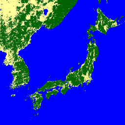
전역 산림/비산림 지도 (FNF)는 강한 후방 산란 픽셀과 낮은 후방 산란 픽셀이 각각 '산림'과 '비산림'으로 할당되도록 전역 25m 해상도 PALSAR-2/PALSAR SAR 모자이크에서 SAR 이미지 (후방 산란 계수)를 분류하여 생성됩니다. 여기서 '산림'은 면적이 0.5ha를 초과하고 산림 피복이 10%를 초과하는 자연 산림으로 정의됩니다. 이 정의는 식량농업기구(FAO)의 정의와 동일합니다. 산림의 레이더 후방 산란은 지역 (기후대)에 따라 달라지므로 산림/비산림 분류는 지역 종속 후방 산란 임계값을 사용하여 수행됩니다. 분류 정확도는 현장 사진과 고해상도 광학 위성 이미지를 사용하여 확인합니다. 자세한 내용은 제공업체의 데이터 세트 설명을 참고하세요.
주의:
역산란 값은 고위도 산림 지역에서 경로에 따라 크게 다를 수 있습니다. 이는 겨울에 나무가 얼어붙어 후방 산란 강도가 변경되기 때문입니다.
이로 인해 산림/비산림 분류가 영향을 받을 수 있습니다.
대역
픽셀 크기 25미터
대역
이름
최소
최대
픽셀 크기
설명
fnf
1
3
미터
산림/비산림 토지 피복 분류
fnf 클래스 표
값
색상
설명
1
#006400
숲
2
#feff99
비산림
3
#0000ff
물
이용약관
이용약관
JAXA는 데이터 세트의 소유권을 보유하며 데이터 세트 사용으로 인해 발생하거나 발생할 수 있는 문제에 대해 보증하지 않습니다.
데이터 세트를 사용하여 결과를 게시하려는 사람은 누구나 게시물에서 데이터의 소유권을 명확하게 인정해야 합니다.
인용
인용:
Masanobu Shimada, Takuya Itoh, Takeshi Motooka, Manabu Watanabe, Shiraishi Tomohiro, Rajesh Thapa, Richard Lucas, 'New Global Forest/Non-forest Maps from ALOS PALSAR Data (2007-2010)', Remote Sensing of Environment, 155, pp. 13~31, 2014년 12월.
doi:10.1016/j.rse.2014.04.014.
2017~2020년의 4개 클래스가 포함된 최신 버전의 데이터 세트는 JAXA/ALOS/PALSAR/YEARLY/FNF4에서 확인할 수 있습니다. 전 세계 산림/비산림 지도 (FNF)는 전 세계 25m 해상도 PALSAR-2/PALSAR SAR 모자이크에서 SAR 이미지 (후방 산란 계수)를 분류하여 생성되므로 강한 후방 산란 픽셀과 낮은 후방 산란 픽셀이 '산림' 및 …
[null,null,[],[[["\u003cp\u003eThe JAXA/ALOS/PALSAR/YEARLY/FNF dataset provides a global forest/non-forest map at 25-meter resolution, classifying areas as forest, non-forest, or water based on SAR backscatter data.\u003c/p\u003e\n"],["\u003cp\u003eThis dataset covers the period from 2007 to 2018 and utilizes a region-dependent threshold for classification to account for variations in radar backscatter across different climate zones.\u003c/p\u003e\n"],["\u003cp\u003eUsers should be aware that backscatter values might differ significantly in high-latitude forest areas due to seasonal changes, potentially affecting the classification accuracy.\u003c/p\u003e\n"],["\u003cp\u003eA newer version of the dataset, JAXA/ALOS/PALSAR/YEARLY/FNF4, offers an updated classification with four classes for the years 2017-2020.\u003c/p\u003e\n"],["\u003cp\u003eJAXA retains ownership of the dataset, and users are required to acknowledge the data source when publishing any results derived from it.\u003c/p\u003e\n"]]],["The JAXA EORC provides a global forest/non-forest (FNF) map dataset from 2007 to 2018. This dataset uses 25m resolution PALSAR-2/PALSAR SAR mosaic images, classifying pixels based on backscatter strength into \"forest,\" \"non-forest,\" and \"water.\" Forest is defined as natural forest with an area over 0.5 ha and cover exceeding 10%. The dataset is accessible via Google Earth Engine using the provided snippet and is classified with an accuracy determined through in-situ and high-resolution optical images.\n"],null,["# Global 3-class PALSAR-2/PALSAR Forest/Non-Forest Map\n\nDataset Availability\n: 2007-01-01T00:00:00Z--2018-01-01T00:00:00Z\n\nDataset Provider\n:\n\n\n [JAXA EORC](https://www.eorc.jaxa.jp/ALOS/en/dataset/fnf_e.htm)\n\nTags\n:\n[alos](/earth-engine/datasets/tags/alos) [alos2](/earth-engine/datasets/tags/alos2) [classification](/earth-engine/datasets/tags/classification) [eroc](/earth-engine/datasets/tags/eroc) [forest](/earth-engine/datasets/tags/forest) [forest-biomass](/earth-engine/datasets/tags/forest-biomass) [jaxa](/earth-engine/datasets/tags/jaxa) [landcover](/earth-engine/datasets/tags/landcover) [palsar](/earth-engine/datasets/tags/palsar) [palsar2](/earth-engine/datasets/tags/palsar2) [sar](/earth-engine/datasets/tags/sar) \n\n#### Description\n\nA newer version of this dataset with 4 classes for 2017-2020 can be found in\n[JAXA/ALOS/PALSAR/YEARLY/FNF4](/earth-engine/datasets/catalog/JAXA_ALOS_PALSAR_YEARLY_FNF4)\n\nThe global forest/non-forest map (FNF) is generated by\nclassifying the SAR image (backscattering coefficient) in the\nglobal 25m resolution PALSAR-2/PALSAR SAR mosaic so that strong and\nlow backscatter pixels are assigned as \"forest\" and \"non-forest\",\nrespectively. Here, \"forest\" is defined as the natural forest\nwith the area larger than 0.5 ha and forest cover over 10%. This\ndefinition is the same as the Food and Agriculture Organization\n(FAO) definition. Since the radar backscatter from the forest\ndepends on the region (climate zone), the classification of\nForest/Non-Forest is conducted by using a region-dependent\nthreshold of backscatter. The classification accuracy is\nchecked by using in-situ photos and high-resolution optical\nsatellite images. Detailed information is available in the provider's\n[Dataset Description](https://www.eorc.jaxa.jp/ALOS/en/palsar_fnf/DatasetDescription_PALSAR2_Mosaic_FNF_revE.pdf).\n\nAttention:\n\n- Backscatter values may vary significantly from path to path over high latitude forest areas. This is due to the change of backscattering intensity caused by freezing trees in winter. Please note that this may affect the classification of forest/non-forest.\n\n### Bands\n\n\n**Pixel Size**\n\n25 meters\n\n**Bands**\n\n| Name | Min | Max | Pixel Size | Description |\n|-------|-----|-----|------------|--------------------------------------------|\n| `fnf` | 1 | 3 | meters | Forest/Non-Forest landcover classification |\n\n**fnf Class Table**\n\n| Value | Color | Description |\n|-------|---------|-------------|\n| 1 | #006400 | Forest |\n| 2 | #feff99 | Non-Forest |\n| 3 | #0000ff | Water |\n\n### Terms of Use\n\n**Terms of Use**\n\nJAXA retains ownership of the dataset and cannot guarantee\nany problem caused by or possibly caused by using the datasets.\nAnyone wishing to publish any results using the datasets should\nclearly acknowledge the ownership of the data in the publication.\n\n### Citations\n\nCitations:\n\n- Masanobu Shimada, Takuya Itoh, Takeshi Motooka, Manabu Watanabe,\n Shiraishi Tomohiro, Rajesh Thapa, and Richard Lucas, \"New Global\n Forest/Non-forest Maps from ALOS PALSAR Data (2007-2010)\", Remote Sensing\n of Environment, 155, pp. 13-31, December 2014.\n [doi:10.1016/j.rse.2014.04.014.](https://doi.org/10.1016/j.rse.2014.04.014)\n\n### Explore with Earth Engine\n\n| **Important:** Earth Engine is a platform for petabyte-scale scientific analysis and visualization of geospatial datasets, both for public benefit and for business and government users. Earth Engine is free to use for research, education, and nonprofit use. To get started, please [register for Earth Engine access.](https://console.cloud.google.com/earth-engine)\n\n### Code Editor (JavaScript)\n\n```javascript\nvar dataset = ee.ImageCollection('JAXA/ALOS/PALSAR/YEARLY/FNF')\n .filterDate('2017-01-01', '2017-12-31');\nvar forestNonForest = dataset.select('fnf');\nvar forestNonForestVis = {\n min: 1,\n max: 3,\n palette: ['006400', 'feff99', '0000ff'],\n};\nMap.setCenter(136.85, 37.37, 4);\nMap.addLayer(forestNonForest, forestNonForestVis, 'Forest/Non-Forest');\n```\n[Open in Code Editor](https://code.earthengine.google.com/?scriptPath=Examples:Datasets/JAXA/JAXA_ALOS_PALSAR_YEARLY_FNF) \n[Global 3-class PALSAR-2/PALSAR Forest/Non-Forest Map](/earth-engine/datasets/catalog/JAXA_ALOS_PALSAR_YEARLY_FNF) \nA newer version of this dataset with 4 classes for 2017-2020 can be found in JAXA/ALOS/PALSAR/YEARLY/FNF4 The global forest/non-forest map (FNF) is generated by classifying the SAR image (backscattering coefficient) in the global 25m resolution PALSAR-2/PALSAR SAR mosaic so that strong and low backscatter pixels are assigned as \"forest\" and ... \nJAXA/ALOS/PALSAR/YEARLY/FNF, alos,alos2,classification,eroc,forest,forest-biomass,jaxa,landcover,palsar,palsar2,sar \n2007-01-01T00:00:00Z/2018-01-01T00:00:00Z \n-90 -180 90 180 \nGoogle Earth Engine \nhttps://developers.google.com/earth-engine/datasets\n\n- [](https://doi.org/https://www.eorc.jaxa.jp/ALOS/en/dataset/fnf_e.htm)\n- [](https://doi.org/https://developers.google.com/earth-engine/datasets/catalog/JAXA_ALOS_PALSAR_YEARLY_FNF)"]]