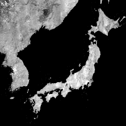
글로벌 25m PALSAR/PALSAR-2 모자이크는 PALSAR/PALSAR-2의 SAR 이미지 스트립을 모자이크하여 만든 연속적인 글로벌 SAR 이미지입니다. 각 연도와 위치에 대해 기간 동안 사용할 수 있는 탐색 모자이크를 시각적으로 검사하여 스트립 데이터를 선택했으며, 표면 수분에 대한 반응이 최소인 데이터가 우선적으로 사용되었습니다.
각 연간 모자이크에는 타겟 연도의 데이터만 사용되었으므로 연간 전 세계 범위에 격차가 있는 경우 이전 연도의 데이터를 사용하여 격차를 채우지 않습니다.
ALOS와 ALOS-2 시간 범위 간의 격차로 인해 2011~2014년 데이터가 없습니다.
SAR 이미지는 디지털 표면 모델 ALOS World 3D - 30m (AW3D30)을 사용하여 직교 보정 및 경사 보정되었습니다.
표면 수분 조건의 계절별 및 일별 차이로 인해 주로 발생하는 인접한 스트립 간의 강도 차이를 균등화하기 위해 디스트라이핑 프로세스 (Shimada & Isoguchi, 2002, 2010)를 적용했습니다.
편광 데이터는 16비트 디지털 번호 (DN)로 저장됩니다.
DN 값은 다음 방정식을 사용하여 데시벨 단위 (dB)의 감마 제로 값으로 변환할 수 있습니다.
γ₀ = 10log₁₀(DN²) - 83.0 dB
주의:
역산란 값은 고위도 산림 지역에서 경로에 따라 크게 다를 수 있습니다. 이는 겨울에 나무가 얼어붙어 후방 산란 강도가 변경되기 때문입니다.
전 세계 25m PALSAR/PALSAR-2 모자이크는 PALSAR/PALSAR-2의 SAR 이미지 스트립을 모자이크하여 만든 연속적인 전 세계 SAR 이미지입니다. 각 연도와 위치에 대해 기간 동안 제공되는 탐색 모자이크를 시각적으로 검사하여 스트립 데이터를 선택했으며, 표면 수분에 대한 반응이 최소인 데이터를 우선적으로 선택했습니다.
[null,null,[],[[["\u003cp\u003eThe JAXA/ALOS/PALSAR/YEARLY/SAR_EPOCH dataset provides a global, seamless 25m resolution mosaic of SAR imagery from the ALOS PALSAR and PALSAR-2 satellites.\u003c/p\u003e\n"],["\u003cp\u003eThe mosaic is created by selecting strips of imagery with minimal surface moisture response for each year and location, prioritizing data from the target year to avoid gap-filling.\u003c/p\u003e\n"],["\u003cp\u003eBackscatter values are provided as 16-bit digital numbers (DN) that can be converted to gamma naught values (dB), and may vary significantly in high latitude forests due to seasonal freezing.\u003c/p\u003e\n"],["\u003cp\u003eThe dataset spans from 2015 to 2023, with a gap between 2011 and 2014 due to the transition between ALOS and ALOS-2.\u003c/p\u003e\n"],["\u003cp\u003eJAXA retains ownership of the data and encourages users to acknowledge its use in publications.\u003c/p\u003e\n"]]],[],null,["# Global PALSAR-2/PALSAR Yearly Mosaic, version 2\n\nDataset Availability\n: 2015-01-01T00:00:00Z--2023-01-01T00:00:00Z\n\nDataset Provider\n:\n\n\n [JAXA EORC](https://www.eorc.jaxa.jp/ALOS/en/dataset/fnf_e.htm)\n\nTags\n:\n[alos](/earth-engine/datasets/tags/alos) [alos2](/earth-engine/datasets/tags/alos2) [eroc](/earth-engine/datasets/tags/eroc) [jaxa](/earth-engine/datasets/tags/jaxa) [palsar](/earth-engine/datasets/tags/palsar) [palsar2](/earth-engine/datasets/tags/palsar2) [sar](/earth-engine/datasets/tags/sar) [satellite-imagery](/earth-engine/datasets/tags/satellite-imagery) \n\n#### Description\n\nThe global 25m PALSAR/PALSAR-2 mosaic is a seamless global\nSAR image created by mosaicking strips of SAR imagery\nfrom PALSAR/PALSAR-2. For each year and location,\nthe strip data were selected through visual inspection of the\nbrowse mosaics available over the period, with those showing minimum\nresponse to surface moisture preferentially used.\nOnly data from the target year have been used for each annual mosaic,\nand hence no gap-filling using data from previous years in case of gaps\nin the annual global coverage.\n\nThere is no data for 2011-2014 due to the gap between ALOS and ALOS-2\ntemporal coverage.\n\nThe SAR imagery was ortho-rectificatied and slope corrected using the\ndigital surface model ALOS World 3D - 30m (AW3D30).\n\nA destriping process (Shimada \\& Isoguchi, 2002, 2010) was applied\nto equalize the intensity differences between neighboring strips,\noccurring largely due to seasonal and daily differences\nin surface moisture conditions.\n\nPolarization data are stored as 16-bit digital numbers (DN).\nThe DN values can be converted to gamma naught values\nin decibel unit (dB) using the following equation:\n\n- γ₀ = 10log₁₀(DN²) - 83.0 dB\n\nAttention:\n\n- Backscatter values may vary significantly from path to path over high latitude forest areas. This is due to the change of backscattering intensity caused by freezing trees in winter.\n\nMore information is available in the provider's\n[Dataset Description](https://www.eorc.jaxa.jp/ALOS/en/dataset/pdf/DatasetDescription_PALSAR2_Mosaic_ver212.pdf).\n\n### Bands\n\n\n**Pixel Size**\n\n25 meters\n\n**Bands**\n\n| Name | Units | Pixel Size | Description |\n|---------|-------|------------|--------------------------------------------------------------------------------------------------------------------------------------------------------------------------------------------------------------------------|\n| `HH` | | meters | HH polarization backscattering coefficient, 16-bit DN. |\n| `HV` | | meters | HV polarization backscattering coefficient, 16-bit DN. |\n| `angle` | deg | meters | Local incidence angle. |\n| `epoch` | | meters | Observation date timestamp (milliseconds since Jan 1, 1970). This band is computed on the fly from the 'date' band of the raw data, which represents the difference in days between 2014-05-24 and the observation date. |\n| `qa` | | meters | Processing information. |\n\n**qa Class Table**\n\n| Value | Color | Description |\n|-------|---------|-----------------|\n| 0 | #000000 | No data |\n| 50 | #0000ff | Ocean and water |\n| 100 | #aaaa00 | Radar layover |\n| 150 | #005555 | Radar shadowing |\n| 255 | #aa9988 | Land |\n\n### Terms of Use\n\n**Terms of Use**\n\nJAXA retains ownership of the dataset and cannot guarantee\nany problem caused by or possibly caused by using the datasets.\nAnyone wishing to publish any results using the datasets should\nclearly acknowledge the ownership of the data in the publication.\n\n### Citations\n\nCitations:\n\n- Masanobu Shimada, Takuya Itoh, Takeshi Motooka, Manabu Watanabe,\n Shiraishi Tomohiro, Rajesh Thapa, and Richard Lucas, \"New Global\n Forest/Non-forest Maps from ALOS PALSAR Data (2007-2010)\", Remote Sensing\n of Environment, 155, pp. 13-31, December 2014.\n [doi:10.1016/j.rse.2014.04.014.](https://doi.org/10.1016/j.rse.2014.04.014)\n\n### Explore with Earth Engine\n\n| **Important:** Earth Engine is a platform for petabyte-scale scientific analysis and visualization of geospatial datasets, both for public benefit and for business and government users. Earth Engine is free to use for research, education, and nonprofit use. To get started, please [register for Earth Engine access.](https://console.cloud.google.com/earth-engine)\n\n### Code Editor (JavaScript)\n\n```javascript\nvar dataset = ee.ImageCollection('JAXA/ALOS/PALSAR/YEARLY/SAR_EPOCH')\n .filter(ee.Filter.date('2017-01-01', '2018-01-01'));\nvar sarHh = dataset.select('HH');\nvar sarHhVis = {\n min: 0.0,\n max: 10000.0,\n};\nMap.setCenter(136.85, 37.37, 4);\nMap.addLayer(sarHh, sarHhVis, 'SAR HH');\n```\n[Open in Code Editor](https://code.earthengine.google.com/?scriptPath=Examples:Datasets/JAXA/JAXA_ALOS_PALSAR_YEARLY_SAR_EPOCH) \n[Global PALSAR-2/PALSAR Yearly Mosaic, version 2](/earth-engine/datasets/catalog/JAXA_ALOS_PALSAR_YEARLY_SAR_EPOCH) \nThe global 25m PALSAR/PALSAR-2 mosaic is a seamless global SAR image created by mosaicking strips of SAR imagery from PALSAR/PALSAR-2. For each year and location, the strip data were selected through visual inspection of the browse mosaics available over the period, with those showing minimum response to surface moisture preferentially ... \nJAXA/ALOS/PALSAR/YEARLY/SAR_EPOCH, alos,alos2,eroc,jaxa,palsar,palsar2,sar,satellite-imagery \n2015-01-01T00:00:00Z/2023-01-01T00:00:00Z \n-90 -180 90 180 \nGoogle Earth Engine \nhttps://developers.google.com/earth-engine/datasets\n\n- [](https://doi.org/https://www.eorc.jaxa.jp/ALOS/en/dataset/fnf_e.htm)\n- [](https://doi.org/https://developers.google.com/earth-engine/datasets/catalog/JAXA_ALOS_PALSAR_YEARLY_SAR_EPOCH)"]]