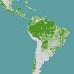
전 세계 산림 분포도는 10m 공간 해상도로 2020년의 산림 존재 및 부재를 공간적으로 명시적으로 나타냅니다.
2020년은 '산림 파괴 및 산림 황폐화와 관련된 특정 상품 및 제품의 연합 시장 출시 및 연합에서의 수출'에 관한 유럽연합 규정(EUDR, 규정 (EU) 2023/1115)의 기준 날짜에 해당합니다.
EUDR의 맥락에서 전 세계 산림 피복 지도는 의무적이지 않고, 독점적이지 않으며, 법적 구속력이 없는 정보 소스로 사용할 수 있습니다.
지도 및 사용에 관한 자세한 내용은 EU 산림 파괴 및 산림 황폐화 관측소 (EUFO)의 자주 묻는 질문 섹션을 참고하세요.
산림은 0.5헥타르를 초과하는 토지로서, 나무 높이가 5미터를 초과하고 수관 밀도가 10%를 초과하는 토지 또는 현장에서 이러한 기준에 도달할 수 있는 나무가 있는 토지를 의미하며, 농업 또는 도시 토지 이용이 주로 이루어지는 토지는 제외됩니다. 농업용이란 농업을 목적으로 토지를 사용하는 것을 의미하며, 농업용 식재 (예: 과수원, 야자나무 농장, 올리브 과수원, 농림업 시스템과 같은 농업 생산 시스템의 나무 군락) 및 농업용 유보지, 가축 사육을 포함합니다. 목재를 제외한 관련 상품(소, 코코아, 커피, 기름야자, 고무, 콩)의 모든 농장은 산림 정의에서 제외됩니다.
산림 범위의 전 세계 지도는 토지 피복, 토지 이용, 나무 높이 등 기존의 전 세계 공간 레이어 (전체 또는 전 세계 범위)를 결합하여 생성되었습니다. 이 지도는 2020년 12월 31일의 산림 피복 상태를 나타냅니다. ESA World Cover 프로젝트의 전 세계 토지 피복은 10m 공간 해상도로 2020년의 수목 피복 범위를 정의하는 기준 레이어 중 하나로 사용됩니다. 2024년에는 사용자 의견과 신규 또는 수정된 공간 데이터 레이어를 통합하여 2020년의 전 세계 산림 피복 지도가 개선되었습니다.
이제 일시적으로 재고가 없는 산림, 밀도가 낮은 열대 우림, 최소 5년 동안 다시 자란 2차 열대 우림을 더 잘 포착합니다. 또한 도시 지역, 광산, 습지, 이동식 경작지가 있는 지역, 나무 농장의 나무를 더 효과적으로 제외할 수 있도록 제외 기준이 개선되었습니다. 이는 캐노피 높이, 농작물 면적, 특정 농작물 상품 지도의 여러 전역 지도를 활용하여 농업용으로 사용되는 나무와 숲을 더 정확하게 구분함으로써 달성됩니다.
직접 액세스 및 메타데이터는 JRC 데이터 카탈로그 (JRC 2024)를 참고하세요. 기술 보고서 (Bourgoin et al 2025)에서는 두 번째 버전의 매핑 접근 방식을 설명합니다. 전 세계 산림 피복 지도에 대한 정확도 평가는 별도의 보고서에 설명되어 있습니다.
2020년에 새로운 정보, 추가 대규모 데이터 레이어 또는 수정된 전역 공간 데이터 레이어를 사용할 수 있게 되면 전 세계 산림 면적 지도가 수정될 수 있습니다.
이 데이터는 허가, 라이선스 또는 로열티 지불 없이 누구나 언제 어디서나 사용할 수 있습니다. 권장 인용을 사용한 저작자 표시는 요청됩니다.
인용
인용:
Bourgoin, Clement; Verhegghen, Astrid; Degreve, Lucas; Ameztoy, Iban;
Carboni, Silvia; Colditz, Rene; Achard, Frederic (2024): Global map of
forest cover 2020 - version 2. European Commission, Joint Research Centre (JRC) [데이터 세트]
PID: http://data.europa.eu/89h/e554d6fb-6340-45d5-9309-332337e5bc26
Bourgoin, C., Verhegghen, A., Carboni, S., Degreve, L., Ameztoy Aramendi, I., Ceccherini, G., Colditz, R. and Achard, F., Global Forest Maps for the Year 2020 to Support the EU Regulation on Deforestation-free Supply Chains(2020년의 글로벌 산림 지도: 삼림 벌채 없는 공급망에 관한 EU 규정 지원), 유럽연합 출판국, 룩셈부르크, 2025, https://data.europa.eu/doi/10.2760/1975879, JRC141702.
Colditz, R., Verhegghen, A., Carboni, S., Bourgoin, C., Duerauer, M., Mansuy, N., De Marzo, T., Beuchle, R., Janouskova, K., Armada Bras, T., Desclée, B., Orlowski, K., Mutendeudzi, M., Ameztoy Aramendi, I., Fritz, S., Lesiv, M., Oom, D., Carreiras, J., San-Miguel, J., Herold, M., Berger, K., Nepomshina, O., Gond, V., Defourny, P., Lamarche, C., Bos, A., Collet, T., Delhez, B., Mollicone, D., Bastin, J.-F., De Haulleville, T., Brink, A., Lupi, A., Tsendbazar, N.E., Stehman, S.V. and Achard, F., Accuracy Assessment of the Global Forest Cover Map for the Year 2020: Assessment Pro-tocol and Analysis, Publications Office of the European Union, Luxembourg, 2025, https://data.europa.eu/doi/10.2760/7632707, JRC141231.
[null,null,[],[[["\u003cp\u003eThe JRC/GFC2020/V2 dataset provides a global map of forest presence and absence for the year 2020 at a 10-meter spatial resolution.\u003c/p\u003e\n"],["\u003cp\u003eThis dataset aligns with the European Union Deforestation Regulation (EUDR) and can serve as a source of information for compliance, though it is not legally binding.\u003c/p\u003e\n"],["\u003cp\u003eForest is defined as areas larger than 0.5 hectares with trees over 5 meters tall and a canopy cover exceeding 10%, excluding agricultural and urban areas, and specific commodity plantations (cattle, cocoa, coffee, oil palm, rubber, soya).\u003c/p\u003e\n"],["\u003cp\u003eThe map was created by combining various global spatial layers and has been refined in 2024 to better represent forest types and exclude non-forest areas.\u003c/p\u003e\n"],["\u003cp\u003eThe dataset is freely available for use without restrictions, but attribution is requested using the provided citation.\u003c/p\u003e\n"]]],[],null,["# EC JRC global map of forest cover 2020, V2\n\nDataset Availability\n: 2020-12-31T00:00:00Z--2020-12-31T00:00:01Z\n\nDataset Provider\n:\n\n\n [Joint Research Centre, European Commission](https://forest-observatory.ec.europa.eu/forest/)\n\nCadence\n: 1 Year\n\nTags\n:\n[eudr](/earth-engine/datasets/tags/eudr) [forest](/earth-engine/datasets/tags/forest) [forest-biomass](/earth-engine/datasets/tags/forest-biomass) [jrc](/earth-engine/datasets/tags/jrc) \n\n#### Description\n\nThe global map of forest cover provides a spatially explicit representation\nof forest presence and absence for the year 2020 at 10m spatial resolution.\n\nThe year 2020 corresponds to the cut-off date of the Regulation from the\nEuropean Union \"on the making available on the Union market and the export\nfrom the Union of certain commodities and products associated with\ndeforestation and forest degradation\" (EUDR, Regulation (EU) 2023/1115).\nIn the context of the EUDR, the global forest cover map can be used as a\nnon-mandatory, non-exclusive and not legally binding source of information.\nFurther information about the map and its use can be found on the [EU\nObservatory on Deforestation and Forest Degradation](https://forest-observatory.ec.europa.eu/forest/) (EUFO) and namely in\nthe section on Frequently Asked Questions.\n\nForest means land spanning more than 0.5 hectares with trees higher than\n5 meters and a canopy cover of more than 10%, or trees able to reach those\nthresholds in situ, excluding land that is predominantly under agricultural\nor urban land use. Agricultural use means the use of land for the purpose of\nagriculture, including for agricultural plantations (i.e. tree stands in\nagricultural production systems such as fruit tree plantations, oil palm\nplantations, olive orchards and agroforestry systems) and set- aside\nagricultural areas, and for rearing livestock. All plantations of relevant\ncommodities other than wood, that is cattle, cocoa, coffee, oil palm,\nrubber, soya are excluded from the forest definition.\n\nThe global map of forest cover was created by combining existing global\nspatial layers (wall-to-wall or global in their scope), e.g. on land cover,\nland use, and tree height. The map aims to represent the state of forest\ncover by 31 December 2020. The global land cover from the ESA World Cover\nproject serves as one baseline layer to define the extent of tree cover for\nyear 2020 at 10 m spatial resolution. In 2024, the global map of forest\ncover 2020 was improved by integrating user feedback, and new or revised\nspatial data layers.\n\nIt now better captures temporally unstocked forests, low-density\ntropical forests, and secondary tropical forests that have regrown for at\nleast five years. Additionally, the exclusion criteria have been enhanced\nto more effectively exclude trees in urban areas, mining sites, wetlands,\nareas with shifting cultivation, and tree plantations. This is achieved by\nutilizing multiple global maps of canopy height, crop area, and specific\ncrop commodity maps to more accurately distinguish forests from trees\nunder agricultural use.\n\nFor direct access and metadata, please consult the JRC\ndata catalogue ([JRC 2024](https://data.jrc.ec.europa.eu/dataset/e554d6fb-6340-45d5-9309-332337e5bc26)). A technical report ([Bourgoin et al 2025](https://op.europa.eu/en/publication-detail/-/publication/e2c286ac-14e9-11f0-b1a3-01aa75ed71a1/language-en))\ndescribes the mapping approach for the second version. The accuracy\nassessment of the Global Forest Cover map is described in a\n[separate report](https://op.europa.eu/en/publication-detail/-/publication/e86f56dd-15b5-11f0-b1a3-01aa75ed71a1/language-en).\n\nThe global map of forest cover may be revised if\nnew information, additional large-scale data layers, or revised global\nspatial data layers will be made available for year 2020.\n\nFor a list of known issues please refer to [this website](https://forobs.jrc.ec.europa.eu/GFC).\n\n### Bands\n\n\n**Pixel Size**\n\n10 meters\n\n**Bands**\n\n| Name | Pixel Size | Description |\n|-------|------------|--------------------------|\n| `Map` | meters | Global forest cover 2020 |\n\n**Map Class Table**\n\n| Value | Color | Description |\n|-------|---------|-------------|\n| 1 | #4d9221 | Forest |\n\n### Terms of Use\n\n**Terms of Use**\n\nThe data may be used by anyone, anywhere, anytime without permission,\nlicense or royalty payment. Attribution using the recommended citation\nis requested.\n\n### Citations\n\nCitations:\n\n- Bourgoin, Clement; Verhegghen, Astrid; Degreve, Lucas; Ameztoy, Iban;\n Carboni, Silvia; Colditz, Rene; Achard, Frederic (2024): Global map of\n forest cover 2020 - version 2. European Commission, Joint Research\n Centre (JRC) \\[Dataset\\]\n PID: \u003chttp://data.europa.eu/89h/e554d6fb-6340-45d5-9309-332337e5bc26\u003e\n- Bourgoin, C., Verhegghen, A., Carboni, S., Degreve, L., Ameztoy Aramendi, I., Ceccherini, G., Colditz, R. and Achard, F., Global Forest Maps for the Year 2020 to Support the EU Regulation on Deforestation-free Supply Chains, Publications Office of the European Union, Luxembourg, 2025, \u003chttps://data.europa.eu/doi/10.2760/1975879\u003e, JRC141702.\n- Colditz, R., Verhegghen, A., Carboni, S., Bourgoin, C., Duerauer, M., Mansuy, N., De Marzo, T., Beuchle, R., Janouskova, K., Armada Bras, T., Desclée, B., Orlowski, K., Mutendeudzi, M., Ameztoy Aramendi, I., Fritz, S., Lesiv, M., Oom, D., Carreiras, J., San-Miguel, J., Herold, M., Berger, K., Nepomshina, O., Gond, V., Defourny, P., Lamarche, C., Bos, A., Collet, T., Delhez, B., Mollicone, D., Bastin, J.-F., De Haulleville, T., Brink, A., Lupi, A., Tsendbazar, N.E., Stehman, S.V. and Achard, F., Accuracy Assessment of the Global Forest Cover Map for the Year 2020: Assessment Pro-tocol and Analysis, Publications Office of the European Union, Luxembourg, 2025, \u003chttps://data.europa.eu/doi/10.2760/7632707\u003e, JRC141231.\n\n### Explore with Earth Engine\n\n| **Important:** Earth Engine is a platform for petabyte-scale scientific analysis and visualization of geospatial datasets, both for public benefit and for business and government users. Earth Engine is free to use for research, education, and nonprofit use. To get started, please [register for Earth Engine access.](https://console.cloud.google.com/earth-engine)\n\n### Code Editor (JavaScript)\n\n```javascript\nvar image2020 = ee.ImageCollection('JRC/GFC2020/V2').mosaic();\n\nvar visualization = {\n bands: ['Map'],\n palette: ['4D9221']};\n\nMap.setCenter(0.0, 0.0, 2);\n\nMap.addLayer(image2020, visualization, 'EC JRC Global forest cover 2020 -- V2');\n```\n[Open in Code Editor](https://code.earthengine.google.com/?scriptPath=Examples:Datasets/JRC/JRC_GFC2020_V2) \n[EC JRC global map of forest cover 2020, V2](/earth-engine/datasets/catalog/JRC_GFC2020_V2) \nThe global map of forest cover provides a spatially explicit representation of forest presence and absence for the year 2020 at 10m spatial resolution. The year 2020 corresponds to the cut-off date of the Regulation from the European Union \"on the making available on the Union market and the export ... \nJRC/GFC2020/V2, eudr,forest,forest-biomass,jrc \n2020-12-31T00:00:00Z/2020-12-31T00:00:01Z \n-90 -180 90 180 \nGoogle Earth Engine \nhttps://developers.google.com/earth-engine/datasets\n\n- [](https://doi.org/https://forest-observatory.ec.europa.eu/forest/)\n- [](https://doi.org/https://developers.google.com/earth-engine/datasets/catalog/JRC_GFC2020_V2)"]]