- 数据集可用时间
- 1975-01-01T00:00:00Z–2030-12-31T00:00:00Z
- 数据集生产者
- EC JRC
- 标签
说明
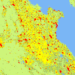
此光栅数据集表示全球多时态城乡分类,应用了联合国统计委员会推荐的“城市化程度”第一阶段方法,基于 GHSL 项目生成的 1975 年至 2030 年(以 5 年为间隔)的全球网格化人口和建成区地表数据。城市化程度图层是通过整合以下信息生成的:从 Landsat 和 Sentinel-2 数据中提取的建成区地表信息 GHS-BUILT-S R2023,以及从 CIESIN GPW v4.11 GHS-POP R2023 推导出的网格化人口数据。此产品是根据 GHS-BUILT-S 和 GHS-POP 的更新情况,对 2023 年发布的数据进行的更新。结算模式以详细级别(第二级 - L2)提供。通过汇总 L2 可以获得第一级分类。
有关 GHSL 主要产品的完整信息,请参阅 GHSL 数据包 2023 年报告
全球人类住区层 (GHSL) 项目由欧盟委员会、联合研究中心以及区域和城市政策总局提供支持。
频段
波段
像素大小:1,000 米(所有波段)
| 名称 | 像元大小 | 说明 |
|---|---|---|
smod_code |
1000 米 | 城市化程度 |
smod_code 类别表
| 值 | 颜色 | 说明 |
|---|---|---|
| -200 | #000000 | 无数据 |
| 10 | #7ab6f5 | 水 |
| 11 | #cdf57a | 极低密度农村地区 |
| 12 | #abcd66 | 低密度农村地区 |
| 13 | #375623 | 农村集群 |
| 21 | #ffff00 | 郊区或城乡结合部 |
| 22 | #a87000 | 半密集型城市群 |
| 23 | #732600 | 密集型城市群 |
| 30 | #ff0000 | 城市中心 |
使用条款
使用条款
GHSL 由欧盟委员会联合研究中心制作,属于开放且免费的数据。只要注明来源,即可重复使用。如需了解详情,请参阅使用条件(欧盟委员会再利用和版权声明)。
引用
数据集:Schiavina, Marcello;Melchiorri, Michele;Pesaresi, Martino (2023):GHS-SMOD R2023A - GHS 人居地层,将城市化程度方法(阶段 I)应用于 GHS-POP R2023A 和 GHS-BUILT-S R2023A,多时相数据 (1975-2030)。 欧盟委员会,联合研究中心 (JRC) PID:http://data.europa.eu/89h/a0df7a6f-49de-46ea-9bde-563437a6e2ba doi:10.2905/A0DF7A6F-49DE-46EA-9BDE-563437A6E2BA
方法:Pesaresi、Martino、Marcello Schiavina、Panagiotis Politis、Sergio Freire、Katarzyna Krasnodebska、Johannes H. Uhl, Alessandra Carioli 等 (2024)。通过联合评估地球观测和人口调查数据,对全球人类住区层进行改进。International Journal of Digital Earth 17(1). doi:10.1080/17538947.2024.2390454.
DOI
通过 Earth Engine 探索
代码编辑器 (JavaScript)
var image = ee.Image("JRC/GHSL/P2023A/GHS_SMOD_V2-0/2030");
var smod = image.select('smod_code');
Map.setCenter(84, 25, 5);
Map.addLayer(image, {}, 'Degree of Urbanization');