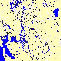
이 데이터 세트에는 1984년부터 2021년까지의 지표수의 위치 및 시간 분포 지도가 포함되어 있으며 이러한 수면의 범위와 변화에 관한 통계를 제공합니다.
자세한 내용은 관련 학술지 논문인 전 세계 지표수 및 장기 변화의 고해상도 매핑(Nature, 2016) 및 온라인 데이터 사용자 가이드를 참고하세요.
이 데이터는 1984년 3월 16일과 2021년 12월 31일 사이에 획득한 Landsat 5,7,8의 장면 4, 716, 475개를 사용하여 생성되었습니다.
각 픽셀은 전문가 시스템을 사용하여 물 / 물 아님으로 개별적으로 분류되었으며, 결과는 전체 기간과 변화 감지를 위한 두 시대 (1984~1999년, 2000~2021년)에 대한 월별 기록으로 정리되었습니다.
이 월별 기록 컬렉션에는 월별 물 감지의 전체 기록이 저장됩니다. 이 컬렉션에는 1984년 3월부터 2021년 12월까지 매달 1개씩 총 454개의 이미지가 포함되어 있습니다.
대역
픽셀 크기 30미터
대역
이름
픽셀 크기
설명
water
미터
해당 월의 물 감지입니다.
물 비트 마스크
비트 0~1: 물 감지
0: 데이터 없음
1: 물이 아님
2: 물
이미지 속성
이미지 속성
이름
유형
설명
월
DOUBLE
월
년
DOUBLE
연도
이용약관
이용약관
여기에 있는 모든 데이터는 Copernicus 프로그램에 따라 생성되며 사용 제한 없이 무료로 제공됩니다. 전체 라이선스 정보는 코페르니쿠스 규정을 참고하세요.
이러한 데이터 세트를 사용하는 간행물, 모델, 데이터 제품에는 다음 인용과 같이 데이터 세트와 학술지 논문을 인용하는 등 적절한 출처 표시가 포함되어야 합니다.
데이터를 게시된 지도의 레이어로 사용하는 경우 '출처: EC JRC/Google'이라는 저작자 표시 텍스트를 포함하세요.
인용
인용:
Jean-Francois Pekel, Andrew Cottam, Noel Gorelick, Alan S. Belward,
High-resolution mapping of global surface water and its long-term changes.
Nature 540, 418~422 (2016). (doi:10.1038/nature20584)
이 데이터 세트에는 1984년부터 2021년까지의 지표수의 위치 및 시간 분포 지도가 포함되어 있으며 이러한 수면의 범위와 변화에 관한 통계가 제공됩니다. 자세한 내용은 관련 학술지 논문인 High-resolution mapping of global surface water and its long-term changes (Nature, 2016) 및 …을 참고하세요.
[null,null,[],[[["\u003cp\u003eThe JRC Monthly Water History dataset provides monthly maps of surface water from 1984 to 2021, derived from Landsat imagery.\u003c/p\u003e\n"],["\u003cp\u003eIt offers insights into the location, extent, and change of surface water over time, including change detection for two epochs (1984-1999 and 2000-2021).\u003c/p\u003e\n"],["\u003cp\u003eThe dataset is freely available for use with proper attribution to EC JRC/Google and citation of the associated journal article.\u003c/p\u003e\n"],["\u003cp\u003eEach pixel is classified as water or non-water, and the data is provided at a 30-meter resolution.\u003c/p\u003e\n"],["\u003cp\u003eThe dataset is accessible through Google Earth Engine and includes monthly images, allowing for detailed analysis of surface water dynamics.\u003c/p\u003e\n"]]],["The dataset, provided by EC JRC/Google, maps surface water location and distribution from March 1984 to December 2021, using Landsat data. It offers monthly water detection history, comprising 454 images with a 30-meter pixel size. Users can access data via an Earth Engine snippet, and the dataset provides water/non-water classification per pixel. It allows for change detection between two epochs and includes data usage guidelines.\n"],null,["# JRC Monthly Water History, v1.4\n\nDataset Availability\n: 1984-03-16T00:00:00Z--2022-01-01T00:00:00Z\n\nDataset Provider\n:\n\n\n [EC JRC / Google](https://global-surface-water.appspot.com)\n\nCadence\n: 1 Month\n\nTags\n:\n[geophysical](/earth-engine/datasets/tags/geophysical) [google](/earth-engine/datasets/tags/google) [history](/earth-engine/datasets/tags/history) [jrc](/earth-engine/datasets/tags/jrc) [landsat-derived](/earth-engine/datasets/tags/landsat-derived) [monthly](/earth-engine/datasets/tags/monthly) [surface](/earth-engine/datasets/tags/surface) [surface-ground-water](/earth-engine/datasets/tags/surface-ground-water) [water](/earth-engine/datasets/tags/water) \n\n#### Description\n\nThis dataset contains maps of the location and temporal\ndistribution of surface water from 1984 to 2021 and provides\nstatistics on the extent and change of those water surfaces.\nFor more information see the associated journal article: [High-resolution\nmapping of global surface water and its long-term changes](https://www.nature.com/nature/journal/v540/n7633/full/nature20584.html)\n(Nature, 2016) and the online\n[Data Users Guide](https://storage.googleapis.com/global-surface-water/downloads_ancillary/DataUsersGuidev2021.pdf).\n\nThese data were generated using 4,716,475 scenes from Landsat\n5, 7, and 8 acquired between 16 March 1984 and 31 December 2021.\nEach pixel was individually classified into water / non-water\nusing an expert system and the results were collated into a monthly\nhistory for the entire time period and two epochs (1984-1999,\n2000-2021) for change detection.\n\nThis Monthly History collection holds the entire history of water detection\non a month-by-month basis. The collection contains 454 images, one for each\nmonth between March 1984 and December 2021.\n\n### Bands\n\n\n**Pixel Size**\n\n30 meters\n\n**Bands**\n\n| Name | Pixel Size | Description |\n|---------|------------|--------------------------------|---|---|---|---|---|---|---|---|---|---|---|---|---|---|---|---|---|---|---|---|---|---|---|---|---|---|---|---|---|---|---|---|---|---|---|---|---|---|---|---|---|---|---|---|---|---|---|---|---|---|---|---|---|---|---|---|---|---|---|---|---|---|---|---|---|---|---|---|---|---|---|---|---|---|---|---|---|---|---|---|---|---|---|---|---|---|---|---|---|---|---|---|---|---|---|---|---|\n| `water` | meters | Water detection for the month. |\n| Bitmask for water - Bits 0-1: Water detection - 0: No data - 1: Not water - 2: Water ||||||||||||||||||||||||||||||||||||||||||||||||||||||||||||||||||||||||||||||||||||||||||||||||||||\n\n### Image Properties\n\n**Image Properties**\n\n| Name | Type | Description |\n|-------|--------|-------------|\n| month | DOUBLE | Month |\n| year | DOUBLE | Year |\n\n### Terms of Use\n\n**Terms of Use**\n\nAll data here is produced under the Copernicus Programme and is provided\nfree of charge, without restriction of use. For the full license\ninformation see the Copernicus Regulation.\n\nPublications, models, and data products that make use of these datasets\nmust include proper acknowledgement, including citing datasets and the\njournal article as in the following citation.\n\nIf you are using the data as a layer in a published map, please include the\nfollowing attribution text: 'Source: EC JRC/Google'\n\n### Citations\n\nCitations:\n\n- Jean-Francois Pekel, Andrew Cottam, Noel Gorelick, Alan S. Belward,\n High-resolution mapping of global surface water and its long-term changes.\n Nature 540, 418-422 (2016). ([doi:10.1038/nature20584](https://doi.org/10.1038/nature20584))\n\n### Explore with Earth Engine\n\n| **Important:** Earth Engine is a platform for petabyte-scale scientific analysis and visualization of geospatial datasets, both for public benefit and for business and government users. Earth Engine is free to use for research, education, and nonprofit use. To get started, please [register for Earth Engine access.](https://console.cloud.google.com/earth-engine)\n\n### Code Editor (JavaScript)\n\n```javascript\nvar dataset = ee.Image('JRC/GSW1_4/MonthlyHistory/2020_06');\n\nvar visualization = {\n bands: ['water'],\n min: 0.0,\n max: 2.0,\n palette: ['ffffff', 'fffcb8', '0905ff']\n};\n\nMap.setCenter(-121.234, 38.109, 7);\n\nMap.addLayer(dataset, visualization, 'Water');\n```\n[Open in Code Editor](https://code.earthengine.google.com/?scriptPath=Examples:Datasets/JRC/JRC_GSW1_4_MonthlyHistory) \n[JRC Monthly Water History, v1.4](/earth-engine/datasets/catalog/JRC_GSW1_4_MonthlyHistory) \nThis dataset contains maps of the location and temporal distribution of surface water from 1984 to 2021 and provides statistics on the extent and change of those water surfaces. For more information see the associated journal article: High-resolution mapping of global surface water and its long-term changes (Nature, 2016) and ... \nJRC/GSW1_4/MonthlyHistory, geophysical,google,history,jrc,landsat-derived,monthly,surface,surface-ground-water,water \n1984-03-16T00:00:00Z/2022-01-01T00:00:00Z \n-59 -180 78 180 \nGoogle Earth Engine \nhttps://developers.google.com/earth-engine/datasets\n\n- [](https://doi.org/https://global-surface-water.appspot.com)\n- [](https://doi.org/https://developers.google.com/earth-engine/datasets/catalog/JRC_GSW1_4_MonthlyHistory)"]]