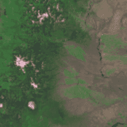
Global Land Survey (GLS) 1975는 Landsat 다중 스펙트럼 스캐너 (MSS)의 전 세계 이미지 모음입니다. 대부분의 장면은 1972~1983년에 Landsat 1~3에 의해 획득되었습니다. Landsat 1~3 데이터의 일부 누락된 부분은 1982~1987년에 Landsat 4~5에서 획득한 장면으로 채워졌습니다. 이 데이터에는 녹색, 빨간색, NIR 대역, SWIR 대역의 4개 스펙트럼 대역이 포함되어 있습니다. 일반적인 거짓 색상 표현에서 이미지는 빨간색으로 표시됩니다. 빨간색으로 표시된 NIR 밴드가 식물을 강조하기 때문입니다.
대역
Pixel Size 60 meters
대역
이름
픽셀 크기
파장
설명
10
미터
500~600nm
초록색
20
미터
600~700nm
빨간색
30
미터
700~800nm
근적외선
40
미터
800~1,100nm
단파장 적외선
이용약관
이용약관
Landsat 데이터 세트는 연방 정부에서 생성한 데이터이므로 퍼블릭 도메인에 속하며 저작권 제한 없이 사용, 전송 또는 복제할 수 있습니다.
데이터 소스로서 USGS를 인용하거나 출처를 표시하려면 아래 예와 같은 텍스트 인용구를 포함해야 합니다.
Global Land Survey (GLS) 1975는 Landsat 다중 스펙트럼 스캐너 (MSS)의 전역 이미지 모음입니다. 대부분의 장면은 1972~1983년에 Landsat 1~3에 의해 획득되었습니다. Landsat 1~3 데이터의 일부 누락된 부분은 1982~1987년에 Landsat 4~5에서 획득한 장면으로 채워졌습니다. 이 데이터는 …
[null,null,[],[[["\u003cp\u003eThe Global Land Survey (GLS) 1975 dataset provides global imagery from the Landsat Multispectral Scanner (MSS) primarily acquired by Landsat 1-3 between 1972 and 1983.\u003c/p\u003e\n"],["\u003cp\u003eIt includes four spectral bands (Green, Red, Near Infrared, and Short-wavelength Infrared) with a resolution of 60 meters.\u003c/p\u003e\n"],["\u003cp\u003eLandsat datasets are public domain and can be used freely with proper citation to the U.S. Geological Survey.\u003c/p\u003e\n"],["\u003cp\u003eThe dataset is available in Earth Engine and can be visualized using false color composites highlighting vegetation.\u003c/p\u003e\n"],["\u003cp\u003eGaps in Landsat 1-3 data within the GLS 1975 collection were filled using Landsat 4-5 imagery from 1982-1987.\u003c/p\u003e\n"]]],[],null,["# Landsat Global Land Survey 1975\n\nDataset Availability\n: 1972-07-25T00:00:00Z--1983-02-20T00:00:00Z\n\nDataset Provider\n:\n\n\n [USGS](https://www.usgs.gov/core-science-systems/nli/landsat/global-land-survey-gls)\n\nTags\n:\n[global](/earth-engine/datasets/tags/global) [gls](/earth-engine/datasets/tags/gls) [landsat](/earth-engine/datasets/tags/landsat) [radiance](/earth-engine/datasets/tags/radiance) [satellite-imagery](/earth-engine/datasets/tags/satellite-imagery) [usgs](/earth-engine/datasets/tags/usgs) \n\n#### Description\n\nThe Global Land Survey (GLS) 1975 is a\nglobal collection of imagery from the Landsat Multispectral\nScanner (MSS). Most scenes were acquired by Landsat 1-3\nin 1972-1983. A few gaps in the Landsat 1-3 data\nhave been filled with scenes acquired by Landsat 4-5 during the\nyears 1982-1987. These data contain 4 spectral bands:\nGreen, Red, an NIR band, and a SWIR band. In the typical\nFalse-color presentation, the images appear red because\nthe NIR band, displayed as red, highlights vegetation.\n\n### Bands\n\n\n**Pixel Size**\n\n60 meters\n\n**Bands**\n\n| Name | Pixel Size | Wavelength | Description |\n|------|------------|-------------|---------------------------|\n| `10` | meters | 500-600 nm | Green |\n| `20` | meters | 600-700 nm | Red |\n| `30` | meters | 700-800 nm | Near infrared |\n| `40` | meters | 800-1100 nm | Short-wavelength infrared |\n\n### Terms of Use\n\n**Terms of Use**\n\nLandsat datasets are federally created data\nand therefore reside in the public domain and may be used, transferred, or reproduced without copyright restriction.\n\nAcknowledgement or credit of the USGS as data source should be provided\nby including a line of text citation such as the example shown below.\n\n(Product, Image, Photograph, or Dataset Name) courtesy of\nthe U.S. Geological Survey\n\nExample: Landsat-7 image courtesy of the U.S. Geological Survey\n\nSee the\n[USGS Visual Identity System Guidance](https://www.usgs.gov/information-policies-and-instructions/usgs-visual-identity-system)\nfor further details on proper citation and acknowledgement of USGS products.\n\n### Citations\n\nCitations:\n\n- GLS 1975 image courtesy of the U.S. Geological Survey\n\n### Explore with Earth Engine\n\n| **Important:** Earth Engine is a platform for petabyte-scale scientific analysis and visualization of geospatial datasets, both for public benefit and for business and government users. Earth Engine is free to use for research, education, and nonprofit use. To get started, please [register for Earth Engine access.](https://console.cloud.google.com/earth-engine)\n\n### Code Editor (JavaScript)\n\n```javascript\nvar dataset = ee.ImageCollection('LANDSAT/GLS1975');\nvar falseColor = dataset.select(['30', '20', '10']);\nvar falseColorVis = {\n gamma: 1.6,\n};\nMap.setCenter(44.517, 25.998, 5);\nMap.addLayer(falseColor, falseColorVis, 'False Color');\n```\n[Open in Code Editor](https://code.earthengine.google.com/?scriptPath=Examples:Datasets/LANDSAT/LANDSAT_GLS1975) \n[Landsat Global Land Survey 1975](/earth-engine/datasets/catalog/LANDSAT_GLS1975) \nThe Global Land Survey (GLS) 1975 is a global collection of imagery from the Landsat Multispectral Scanner (MSS). Most scenes were acquired by Landsat 1-3 in 1972-1983. A few gaps in the Landsat 1-3 data have been filled with scenes acquired by Landsat 4-5 during the years 1982-1987. These data ... \nLANDSAT/GLS1975, global,gls,landsat,radiance,satellite-imagery,usgs \n1972-07-25T00:00:00Z/1983-02-20T00:00:00Z \n-90 -180 90 180 \nGoogle Earth Engine \nhttps://developers.google.com/earth-engine/datasets\n\n- [](https://doi.org/https://www.usgs.gov/core-science-systems/nli/landsat/global-land-survey-gls)\n- [](https://doi.org/https://developers.google.com/earth-engine/datasets/catalog/LANDSAT_GLS1975)"]]