- 데이터 세트 사용 가능 기간
- 1987-01-01T00:00:00Z–2017-01-01T00:00:00Z
- 데이터 세트 제공업체
- 다이 야마자키 (도쿄대학교)
- 태그
설명
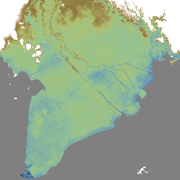
MERIT DEM은 기존 DEM (NASA SRTM3 DEM, JAXA AW3D DEM, Viewfinder Panoramas DEM)에서 주요 오류 구성요소를 제거하여 생성된 3초 해상도(~적도에서 90m)의 고정밀 전역 DEM입니다.
MERIT DEM은 여러 위성 데이터 세트와 필터링 기법을 사용하여 절대 편향, 스트라이프 노이즈, 스페클 노이즈, 나무 높이 편향을 분리합니다. 오류를 제거한 후 수직 정확도가 2m 이상인 지역이 39% 에서 58%로 증가했습니다. 지형 변동보다 높이 오류가 큰 평탄한 지역에서 상당한 개선이 있었으며, 하천 네트워크 및 언덕-계곡 구조와 같은 지형이 명확하게 표현되었습니다.
'MERIT DEM은 다음 제품을 기준 데이터로 처리하여 개발되었습니다.
위의 기준 DEM 외에도 다음 제품이 보조 데이터로 사용되었습니다.
대역
대역
| 이름 | 픽셀 크기 | 설명 |
|---|---|---|
dem |
92.77미터 | EGM96 지오이드 모델을 참조한 고도(미터)입니다. |
이용약관
이용약관
MERIT DEM을 단순히 사용하는 경우 논문 인용으로 충분합니다. 데이터 세트의 추가 처리/편집에 대한 도움을 요청했거나 연구 결과가 제품에 크게 의존하는 경우 개발자가 공동 저자 지정을 요청할 수 있습니다.
MERIT DEM은 크리에이티브 커먼즈 'CC-BY-NC 4.0' 또는 Open Data Commons 'Open Database License (ODbL 1.0)'에 따라 라이선스가 부여됩니다. 이중 라이선스를 사용하면 적절한 라이선스를 선택할 수 있습니다.
이 라이선스의 사본을 보려면 다음 페이지를 방문하세요.
- CC-BY-NC 4.0 라이선스: 제한이 적은 비상업적 용도
- ODbL 1.0 라이선스: 상업적 사용은 허용되지만 MERIT DEM을 기반으로 하는 파생 데이터는 동일한 ODbL 라이선스에 따라 공개적으로 제공되어야 합니다. 예를 들어 MERIT DEM을 사용하여 홍수 위험 지도를 만들고 이를 기반으로 상업용 서비스를 제공하려면 OdBL 라이선스에 따라 위험 지도를 공개적으로 제공해야 합니다.
위 라이선스 약관은 MERIT DEM을 기반으로 한 '파생 데이터'에 적용되지만 MERIT DEM으로 만든 '제작된 작업 / 작품'(예: 학술지 논문의 그림)에는 적용되지 않습니다. 생성된 작업이 '파생 데이터'로 간주되지 않는 경우 사용자는 아트워크의 저작권을 보유할 수 있으며 라이선스를 할당할 수 있습니다.
데이터를 다운로드하고 사용하면 사용자는 이러한 라이선스 중 하나의 이용약관에 동의하는 것으로 간주됩니다. 이 무료 라이선스에도 불구하고 사용자는 저자의 명시적인 서면 허가 없이 다른 웹사이트에서 원래 형식으로 데이터를 전체적으로 재배포하지 않아야 합니다.
MERIT DEM의 저작권은 개발자가 보유합니다(2018, 모든 권리 보유).
인용
Yamazaki D., D. Ikeshima, R. Tawatari, T. Yamaguchi, F. O'Loughlin, J.C. Neal, C.C. Sampson, S. Kanae & P.D. Bates. 전 세계 지형 고도의 정확도가 높은 지도입니다. Geophysical Research Letters, vol.44, pp.5844-5853, 2017.
Earth Engine으로 탐색하기
코드 편집기(JavaScript)
var dataset = ee.Image('MERIT/DEM/v1_0_3');

var visualization = {
  bands: ['dem'],
  min: -3,
  max: 18,
  palette: [
    '000000', '478fcd', '86c58e', 'afc35e',
    '8f7131', 'b78d4f', 'e2b8a6', 'ffffff']
};

Map.setCenter(90.301, 23.052, 10);

Map.addLayer(dataset, visualization, 'Elevation');