- 데이터 세트 사용 가능 기간
- 1987-01-01T00:00:00Z–2017-01-01T00:00:00Z
- 데이터 세트 제공업체
- 다이 야마자키 (도쿄대학교)
- 태그
설명
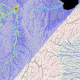
MERIT Hydro의 보조 시각화 레이어
대역
픽셀 크기
556.6미터
대역
| 이름 | 단위 | 픽셀 크기 | 설명 |
|---|---|---|---|
wth |
미터 | 채널 중심선의 하천 채널 너비입니다. 하천 채널 너비는 [Yamazaki et al. 2012, WRR]에 설명된 방법으로 계산되며 알고리즘이 일부 개선/변경되었습니다. 이 대역은 전 세계 규모에서 더 나은 시각화를 위해 원래 3초에서 18초로 업스케일되었습니다. |
|
upa |
km^2 | 미터 | 상류 배수 지역 (흐름 누적 지역) 이 밴드는 전역 규모에서 더 나은 시각화를 위해 원래 3초에서 18초로 업스케일되었습니다. |
이용약관
이용약관
MERIT Hydro를 사용하는 경우 논문을 인용하면 됩니다. 데이터 세트의 추가 처리/편집에 대한 도움을 요청했거나 연구 결과가 제품에 크게 의존하는 경우 개발자가 공동 저자 지정을 요청합니다.
MERIT Hydro는 크리에이티브 커먼즈 'CC-BY-NC 4.0' 또는 Open Data Commons 'Open Database License (ODbL 1.0)'에 따라 라이선스가 부여됩니다. 이중 라이선스를 사용하면 적절한 라이선스를 선택할 수 있습니다.
이 라이선스의 사본을 보려면 다음 페이지를 방문하세요.
- CC-BY-NC 4.0 라이선스: 제한이 적은 비상업적 용도
- ODbL 1.0 라이선스: 상업적 사용은 허용되지만 MERIT Hydro를 기반으로 파생된 데이터는 동일한 ODbL 라이선스에 따라 공개적으로 제공되어야 합니다. 예를 들어 MERIT Hydro를 사용하여 홍수 위험 지도를 만들고 이를 기반으로 상업용 서비스를 제공하려면 OdBL 라이선스에 따라 위험 지도를 공개적으로 제공해야 합니다.
위 라이선스 약관은 MERIT Hydro를 기반으로 하는 '파생 데이터'에 적용되지만 MERIT Hydro로 생성된 '제작된 작업 / 작품'(예: 학술지 논문의 그림)에는 적용되지 않습니다. 생성된 작업이 '파생 데이터'로 간주되지 않는 경우 사용자는 아트워크의 저작권을 보유할 수 있으며 라이선스를 할당할 수 있습니다.
데이터를 다운로드하고 사용하면 사용자는 라이선스 이용약관에 동의하는 것으로 간주됩니다. 이 무료 라이선스에도 불구하고 Google은 사용자가 저자의 명시적인 서면 허가 없이 다른 웹사이트에서 원래 형식으로 데이터를 전체적으로 재배포하지 않도록 요청합니다.
MERIT Hydro의 저작권은 개발자에게 있으며, 2019년, 모든 권리 보유.
인용
Yamazaki D., D. Ikeshima, J. Sosa, P.D. Bates, G.H. Allen, T.M. Pavelsky. MERIT Hydro: 최신 지형 데이터 세트를 기반으로 하는 고해상도 전 세계 수로학 지도 Water Resources Research, vol.55, pp.5053-5073, 2019, doi:10.1029/2019WR024873
Earth Engine으로 탐색하기
코드 편집기(JavaScript)
var dataset = ee.Image('MERIT/Hydro_reduced/v1_0_1');

var visualization = {
  bands: 'wth',
  min: 0,
  max: 400
};

Map.setCenter(90.301, 23.052, 10);

Map.addLayer(dataset, visualization, 'River width');