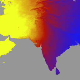
Das Produkt MCD18A1 Version 6.1 ist ein kombiniertes Downward Shortwave Radiation (DSR) Level 3-Produkt von MODIS (Moderate Resolution Imaging Spectroradiometer) Terra und Aqua, das täglich mit einer Pixelauflösung von 1 Kilometer und mit DSR-Schätzungen alle 3 Stunden erstellt wird. Die DSR ist die einfallende Sonnenstrahlung über Landoberflächen im kurzwelligen Spektrum (300–4.000 Nanometer) und eine wichtige Variable in Landoberflächenmodellen,die sich mit einer Vielzahl von wissenschaftlichen und anwendungsbezogenen Problemen befassen. Die MCD18-Produkte basieren auf einem Prototyping-Algorithmus, der multitemporale Signaturen von MODIS-Daten verwendet, um die Oberflächenreflexion abzuleiten und dann die einfallende DSR mithilfe des Look-up-Tabellenansatzes (LUT) zu berechnen. Die LUTs berücksichtigen verschiedene Arten von Belastungen durch Aerosole und Wolken bei unterschiedlichen Beleuchtungs-/Betrachtungsgeometrien. Globale DSR-Produkte werden aus MODIS- und geostationären Satellitendaten generiert.
Weitere Informationen zur Methodik, die zum Erstellen der Daten verwendet wurde, finden Sie im Algorithm Theoretical Basis Document.
Bänder
Pixelgröße 500 Meter
Bänder
Name
Einheiten
Min.
Max.
Pixelgröße
Beschreibung
DSR
W/m^2
0
1400
Meter
Momentaner DSR-Gesamtwert bei MODIS-Überflug
Direct
W/m^2
0
1400
Meter
Momentaner direkter DSR bei MODIS-Überflug
Diffuse
W/m^2
0
1400
Meter
Sofortiger diffuser DSR bei MODIS-Überflug
GMT_0000_DSR
W/m^2
0
1400
Meter
Gesamt-DSR um 00:00 Uhr GMT
GMT_0300_DSR
W/m^2
0
1400
Meter
Gesamt-DSR um 03:00 Uhr GMT
GMT_0600_DSR
W/m^2
0
1400
Meter
Gesamt-DSR um 06:00 Uhr GMT
GMT_0900_DSR
W/m^2
0
1400
Meter
Gesamt-DSR um 09:00 Uhr GMT
GMT_1200_DSR
W/m^2
0
1400
Meter
Gesamt-DSR um 12:00 Uhr GMT
GMT_1500_DSR
W/m^2
0
1400
Meter
Gesamt-DSR um 15:00 Uhr GMT
GMT_1800_DSR
W/m^2
0
1400
Meter
Gesamt-DSR um 18:00 Uhr GMT
GMT_2100_DSR
W/m^2
0
1400
Meter
Gesamt-DSR um 21:00 Uhr GMT
DSR_Quality
Meter
Qualitätskennzeichnung
Bitmaske für DSR_Quality
Bits 0–1: Eingabequelle für Daten zur Oberflächenreflektanz
0: Keine gültigen Daten zur Oberflächenreflektanz
1: aus dem MCD43-Produkt
2. aus den klimatologischen Daten
Nutzungsbedingungen
Nutzungsbedingungen
Für MODIS-Daten und ‑Produkte, die über das LP DAAC bezogen werden, gelten keine Einschränkungen hinsichtlich der weiteren Verwendung, des Verkaufs oder der Weitergabe.
MCD18A1 Version 6.1 ist ein kombiniertes Downward Shortwave Radiation (DSR) Level 3-Produkt von MODIS (Moderate Resolution Imaging Spectroradiometer) Terra und Aqua, das täglich mit einer Pixelauflösung von 1 Kilometer und mit DSR-Schätzungen alle 3 Stunden erstellt wird. DSR ist die einfallende Solarstrahlung über Landoberflächen im kurzwelligen Spektrum (300–4.000 …
[null,null,[],[[["\u003cp\u003eMCD18A1 V6.1 provides daily, 1km resolution estimates of Downward Shortwave Radiation (DSR) over land, including instantaneous and 3-hour measurements.\u003c/p\u003e\n"],["\u003cp\u003eThe dataset is based on MODIS Terra and Aqua data, utilizing surface reflectance to calculate DSR using a look-up table approach that accounts for aerosols and clouds.\u003c/p\u003e\n"],["\u003cp\u003eIt covers the period from 2000-02-24 to 2024-06-01 and is superseded by V6.2, which is not yet available in Earth Engine.\u003c/p\u003e\n"],["\u003cp\u003eWhile it offers instantaneous and 3-hour DSR data, it is important to note that the V6.1 dataset is no longer being produced.\u003c/p\u003e\n"],["\u003cp\u003eUsers can explore and analyze the dataset within Google Earth Engine.\u003c/p\u003e\n"]]],["This dataset provides daily Downward Shortwave Radiation (DSR) data from the MODIS instrument, combining Terra and Aqua satellite measurements. It offers 3-hourly DSR estimates at a 1-kilometer resolution, covering land surfaces. The data spans from February 24, 2000, to June 1, 2024 and includes instantaneous, direct, diffuse DSR and total DSR at 3-hour intervals in Coordinated Universal Time. It is accessible through Earth Engine with the dataset ID MODIS/061/MCD18A1. Please note that this dataset has been superseded.\n"],null,["# MCD18A1.061 Surface Radiation Daily/3-Hour [deprecated]\n\n**Caution:** This dataset has been superseded by [MODIS/062/MCD18A1](/earth-engine/datasets/catalog/MODIS_062_MCD18A1). \n\nDataset Availability\n: 2000-02-24T00:00:00Z--2024-06-01T00:00:00Z\n\nDataset Provider\n:\n\n\n [NASA LP DAAC at the USGS EROS Center](https://lpdaac.usgs.gov/products/mcd18a1v061/)\n\nCadence\n: 1 Day\n\nTags\n:\n climate \n par \nradiation \n\n#### Description\n\nThe MCD18A1 Version 6.1\nis a Moderate Resolution Imaging Spectroradiometer\n(MODIS) Terra and Aqua combined Downward Shortwave Radiation (DSR) gridded\nLevel 3 product produced daily at 1 kilometer pixel resolution with\nestimates of DSR every 3 hours. DSR is incident solar radiation over land\nsurfaces in the shortwave spectrum (300-4,000 nanometers) and is an\nimportant variable in land-surface models that address a variety of\nscientific and application issues. The MCD18 products are based on a\nprototyping algorithm that uses multi-temporal signatures of MODIS data to\nderive surface reflectance and then calculate incident DSR using the look-up\ntable (LUT) approach. The LUTs consider different types of loadings of\naerosols and clouds at a variety of illumination/viewing geometry. Global\nDSR products are generated from MODIS and geostationary satellite data.\nAdditional details regarding the methodology used to create the data are\navailable in the\n[Algorithm Theoretical Basis Document](https://lpdaac.usgs.gov/documents/106/MCD18_ATBD.pdf).\n\n### Bands\n\n\n**Pixel Size**\n\n500 meters\n\n**Bands**\n\n| Name | Units | Min | Max | Pixel Size | Description |\n|----------------|--------|-----|------|------------|---------------------------------------------|---|---|---|---|---|---|---|---|---|---|---|---|---|---|---|---|---|---|---|---|---|---|---|---|---|---|---|---|---|---|---|---|---|---|---|---|---|---|---|---|---|---|---|---|---|---|---|---|---|---|---|---|---|---|---|---|---|---|---|---|---|---|---|---|---|---|---|---|---|---|---|---|---|---|---|---|---|---|---|---|---|---|---|---|---|---|---|---|---|---|---|---|---|---|\n| `DSR` | W/m\\^2 | 0 | 1400 | meters | Instantaneous total DSR at MODIS overpass |\n| `Direct` | W/m\\^2 | 0 | 1400 | meters | Instantaneous direct DSR at MODIS overpass |\n| `Diffuse` | W/m\\^2 | 0 | 1400 | meters | Instantaneous diffuse DSR at MODIS overpass |\n| `GMT_0000_DSR` | W/m\\^2 | 0 | 1400 | meters | Total DSR at GMT 00:00 |\n| `GMT_0300_DSR` | W/m\\^2 | 0 | 1400 | meters | Total DSR at GMT 03:00 |\n| `GMT_0600_DSR` | W/m\\^2 | 0 | 1400 | meters | Total DSR at GMT 06:00 |\n| `GMT_0900_DSR` | W/m\\^2 | 0 | 1400 | meters | Total DSR at GMT 09:00 |\n| `GMT_1200_DSR` | W/m\\^2 | 0 | 1400 | meters | Total DSR at GMT 12:00 |\n| `GMT_1500_DSR` | W/m\\^2 | 0 | 1400 | meters | Total DSR at GMT 15:00 |\n| `GMT_1800_DSR` | W/m\\^2 | 0 | 1400 | meters | Total DSR at GMT 18:00 |\n| `GMT_2100_DSR` | W/m\\^2 | 0 | 1400 | meters | Total DSR at GMT 21:00 |\n| `DSR_Quality` | | | | meters | Quality flag |\n| Bitmask for DSR_Quality - Bits 0-1: Input source of surface reflectance data - 0: no valid surface reflectance data - 1: from the MCD43 product - 2: from the climatology data ||||||||||||||||||||||||||||||||||||||||||||||||||||||||||||||||||||||||||||||||||||||||||||||||||||\n\n### Terms of Use\n\n**Terms of Use**\n\nMODIS data and products acquired through the LP DAAC\nhave no restrictions on subsequent use, sale, or redistribution.\n\n### Citations\n\nCitations:\n\n- Please visit [LP DAAC 'Citing Our Data' page](https://lpdaac.usgs.gov/citing_our_data)\n for information on citing LP DAAC datasets.\n\n### DOIs\n\n- \u003chttps://doi.org/10.5067/MODIS/MCD18A1.061\u003e\n\n### Explore with Earth Engine\n\n| **Important:** Earth Engine is a platform for petabyte-scale scientific analysis and visualization of geospatial datasets, both for public benefit and for business and government users. Earth Engine is free to use for research, education, and nonprofit use. To get started, please [register for Earth Engine access.](https://console.cloud.google.com/earth-engine)\n\n### Code Editor (JavaScript)\n\n```javascript\nvar dataset = ee.ImageCollection('MODIS/061/MCD18A1')\n .filter(ee.Filter.date('2000-01-01', '2001-01-01'));\nvar gmt_1200_dsr = dataset.select('GMT_1200_DSR');\nvar gmt_1200_dsr_vis = {\n min: 0,\n max: 350,\n palette: ['0f17ff', 'b11406', 'f1ff23'],\n};\nMap.setCenter(6.746, 46.529, 2);\nMap.addLayer(\n gmt_1200_dsr, gmt_1200_dsr_vis,\n 'Total dsr at GMT 12:00');\n```\n[Open in Code Editor](https://code.earthengine.google.com/?scriptPath=Examples:Datasets/MODIS/MODIS_061_MCD18A1) \n[MCD18A1.061 Surface Radiation Daily/3-Hour \\[deprecated\\]](/earth-engine/datasets/catalog/MODIS_061_MCD18A1) \nThe MCD18A1 Version 6.1 is a Moderate Resolution Imaging Spectroradiometer (MODIS) Terra and Aqua combined Downward Shortwave Radiation (DSR) gridded Level 3 product produced daily at 1 kilometer pixel resolution with estimates of DSR every 3 hours. DSR is incident solar radiation over land surfaces in the shortwave spectrum (300-4,000 ... \nMODIS/061/MCD18A1, climate,par,radiation \n2000-02-24T00:00:00Z/2024-06-01T00:00:00Z \n-90 -180 90 180 \nGoogle Earth Engine \nhttps://developers.google.com/earth-engine/datasets\n\n- [https://doi.org/10.5067/MODIS/MCD18A1.061](https://doi.org/https://lpdaac.usgs.gov/products/mcd18a1v061/)\n- [https://doi.org/10.5067/MODIS/MCD18A1.061](https://doi.org/https://developers.google.com/earth-engine/datasets/catalog/MODIS_061_MCD18A1)"]]