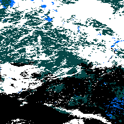
MOD10A2는 Terra 위성의 MODIS에서 가져온 눈 덮개 데이터 세트입니다.
이 데이터 세트는 500m 해상도로 8일 동안의 최대 눈 덮개 범위를 보고합니다.
8일의 합성 기간은 Terra 및 Aqua 플랫폼의 정확한 지상 트랙 반복 기간이기 때문에 선택되었습니다. 8일이 넘는 눈 덮개는 한 SDS에서 최대 눈 덮개 범위로 매핑되고 다른 SDS에서는 관측 연대기로 매핑됩니다. 8일 기간은 연도의 첫날에 시작하여 다음 해까지 이어집니다. 이 제품은 2~8일의 입력으로 생성할 수 있습니다. 다양한 이유로 입력이 8일 동안 이루어지지 않을 수 있으므로 사용자는 속성을 확인하여 관측이 이루어진 날짜를 확인해야 합니다.
사용에 대한 제한사항이 구체적으로 명시되지 않는 한 NSIDC 웹사이트에서 사진, 이미지 또는 텍스트를 다운로드하여 사용할 수 있습니다. NSIDC 데이터 세트의 사용 및 인용에 대한 자세한 내용은 NSIDC '사용 및 저작권' 페이지를 참고하세요.
인용
인용:
Hall, D. K., V. V. Salomonson, and G. A. 리그스. 2016년. MODIS/Terra
Snow Cover Daily L3 Global 500m Grid. 버전 6 Boulder, Colorado
USA: NASA National Snow and Ice Data Center Distributed Active
Archive Center.
[null,null,[],[[["\u003cp\u003eThe MOD10A2 dataset provides information on snow cover, collected by the MODIS sensor on the Terra satellite, spanning from February 18, 2000, to January 25, 2025.\u003c/p\u003e\n"],["\u003cp\u003eThis dataset reports the maximum snow cover extent over eight-day periods at a 500-meter resolution, with data provided by NASA NSIDC DAAC at CIRES.\u003c/p\u003e\n"],["\u003cp\u003eThe dataset includes the maximum snow extent observed over eight days, and a snow chronology bitmask, both of which use specific value ranges to represent no snow, cloud cover, or snow.\u003c/p\u003e\n"],["\u003cp\u003eThe data is collected daily, and the eight day collection period is chosen to match the exact ground track of the Terra and Aqua platforms.\u003c/p\u003e\n"],["\u003cp\u003eUsers can access and analyze the dataset using Google Earth Engine, which is free for research, education, and nonprofit purposes, and can be registered to gain access.\u003c/p\u003e\n"]]],[],null,["# MOD10A2.061 Terra Snow Cover 8-Day L3 Global 500m\n\nDataset Availability\n: 2000-02-18T00:00:00Z--2025-08-05T00:00:00Z\n\nDataset Provider\n:\n\n\n [NASA NSIDC DAAC at CIRES](https://doi.org/10.5067/MODIS/MOD10A2.061)\n\nCadence\n: 1 Day\n\nTags\n:\n[cryosphere](/earth-engine/datasets/tags/cryosphere) [daily](/earth-engine/datasets/tags/daily) [geophysical](/earth-engine/datasets/tags/geophysical) [global](/earth-engine/datasets/tags/global) [modis](/earth-engine/datasets/tags/modis) [nasa](/earth-engine/datasets/tags/nasa) [nsidc](/earth-engine/datasets/tags/nsidc) [snow](/earth-engine/datasets/tags/snow) [terra](/earth-engine/datasets/tags/terra) \n\n#### Description\n\nMOD10A2 is a snow cover dataset from the MODIS on the Terra satellite.\nThe dataset reports the maximum snow cover extent during an eight-day\nperiod at the resolution of 500 m.\n\nAn eight-day compositing period was chosen because that is the exact ground\ntrack repeat period of the Terra and Aqua platforms. Snow cover over eight\ndays is mapped as maximum snow extent in one SDS and as a chronology of\nobservations in the other SDS. Eight-day periods begin on the first day of\nthe year and extend into the next year. The product can be produced with\ntwo to eight days of input. There may not always be eight days of input,\nbecause of various reasons, so the user should check the attributes to\ndetermine on what days observations were obtained.\n\n- [General documentation](https://doi.org/10.5067/MODIS/MOD10A2.061)\n- [User's Guide](https://modis-snow-ice.gsfc.nasa.gov/uploads/snow_user_guide_C6.1_final_revised_april.pdf),\n\n### Bands\n\n\n**Pixel Size**\n\n500 meters\n\n**Bands**\n\n| Name | Min | Max | Pixel Size | Description |\n|------------------------|-----|-----|------------|-----------------------------------------------------------------------------|---|---|---|---|---|---|---|---|---|---|---|---|---|---|---|---|---|---|---|---|---|---|---|---|---|---|---|---|---|---|---|---|---|---|---|---|---|---|---|---|---|---|---|---|---|---|---|---|---|---|---|---|---|---|---|---|---|---|---|---|---|---|---|---|---|---|---|---|---|---|---|---|---|---|---|---|---|---|---|---|---|---|---|---|---|---|---|---|---|---|---|---|---|---|---|\n| `Maximum_Snow_Extent` | 0 | 255 | meters | Maximum snow extent observed over an eight-day period. |\n| `Eight_Day_Snow_Cover` | | | meters | Snow chronology bit flags for each day in the eight-day observation period. |\n| Bitmask for Eight_Day_Snow_Cover - Bit 0: day 1 - Bit 1: day 2 - Bit 2: day 3 - Bit 3: day 4 - Bit 4: day 5 - Bit 5: day 6 - Bit 6: day 7 - Bit 7: day 8 ||||||||||||||||||||||||||||||||||||||||||||||||||||||||||||||||||||||||||||||||||||||||||||||||||||\n\n**Maximum_Snow_Extent Class Table**\n\n| Value | Color | Description |\n|-------|-------|--------------------|\n| 0 | None | Missing data |\n| 1 | None | No decision |\n| 11 | None | Night |\n| 25 | None | No snow |\n| 37 | None | Lake |\n| 39 | None | Ocean |\n| 50 | None | Cloud |\n| 100 | None | Lake ice |\n| 200 | None | Snow |\n| 254 | None | Detector saturated |\n\n### Terms of Use\n\n**Terms of Use**\n\nYou may download and use photographs, imagery, or text\nfrom the NSIDC web site, unless limitations for its use are specifically\nstated. For more information on usage and citing NSIDC datasets,\nplease visit the\n[NSIDC 'Use and Copyright' page](https://nsidc.org/about/data-use-and-copyright).\n\n### Citations\n\nCitations:\n\n- Hall, D. K., V. V. Salomonson, and G. A. Riggs. 2016. MODIS/Terra\n Snow Cover Daily L3 Global 500m Grid. Version 6. Boulder, Colorado\n USA: NASA National Snow and Ice Data Center Distributed Active\n Archive Center.\n\n### DOIs\n\n- \u003chttps://doi.org/10.5067/MODIS/MOD10A1.061\u003e\n- \u003chttps://doi.org/10.5067/MODIS/MOD10A2.061\u003e\n\n### Explore with Earth Engine\n\n| **Important:** Earth Engine is a platform for petabyte-scale scientific analysis and visualization of geospatial datasets, both for public benefit and for business and government users. Earth Engine is free to use for research, education, and nonprofit use. To get started, please [register for Earth Engine access.](https://console.cloud.google.com/earth-engine)\n\n### Code Editor (JavaScript)\n\n```javascript\nvar dataset = ee.ImageCollection('MODIS/061/MOD10A2')\n .filter(ee.Filter.date('2023-01-01', '2023-12-01'))\n .select('Maximum_Snow_Extent');\n\nvar visualization = {\n min: 50.0,\n max: 200.0,\n palette: [\n '000000',\n '0dffff',\n '0524ff',\n 'ffffff'\n ]\n};\n\n\nMap.setCenter(-3.69, 65.99, 4);\n\nMap.addLayer(dataset.mean(), visualization, 'Maximum_Snow_Extent');\n```\n[Open in Code Editor](https://code.earthengine.google.com/?scriptPath=Examples:Datasets/MODIS/MODIS_061_MOD10A2) \n[MOD10A2.061 Terra Snow Cover 8-Day L3 Global 500m](/earth-engine/datasets/catalog/MODIS_061_MOD10A2) \nMOD10A2 is a snow cover dataset from the MODIS on the Terra satellite. The dataset reports the maximum snow cover extent during an eight-day period at the resolution of 500 m. An eight-day compositing period was chosen because that is the exact ground track repeat period of the Terra and ... \nMODIS/061/MOD10A2, cryosphere,daily,geophysical,global,modis,nasa,nsidc,snow,terra \n2000-02-18T00:00:00Z/2025-08-05T00:00:00Z \n-90 -180 90 180 \nGoogle Earth Engine \nhttps://developers.google.com/earth-engine/datasets\n\n- [https://doi.org/10.5067/MODIS/MOD10A2.061](https://doi.org/https://doi.org/10.5067/MODIS/MOD10A2.061)\n- [https://doi.org/10.5067/MODIS/MOD10A2.061](https://doi.org/https://developers.google.com/earth-engine/datasets/catalog/MODIS_061_MOD10A2)"]]