- 데이터 세트 제공
- 2002-07-04T00:00:00Z–2025-11-09T00:00:00Z
- 데이터 세트 제공업체
- USGS EROS 센터 NASA LP DAAC
- 주기
- 16일
- 태그
설명
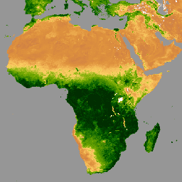
Aqua Moderate Resolution Imaging Spectroradiometer (MODIS) Vegetation Indices 16-Day (MYD13C1) 버전 6.1 제품은 픽셀당 식생 지수 (VI) 값을 제공합니다. 두 가지 기본 식물층이 있습니다. 첫 번째는 정규 식생 지수 (NDVI)로, 기존 국립해양대기청-고해상도 가시광선 및 적외선 스캐너 (NOAA-AVHRR)에서 파생된 NDVI와 연속성을 유지합니다. 두 번째 식생 레이어는 고생물량 지역에서 감도를 개선한 향상된 식생 지수 (EVI)입니다.
기후 모델링 그리드 (CMG)는 5,600미터 (m) 픽셀의 3,600개 행과 7,200개 열로 구성됩니다. 글로벌 MYD13C1 데이터는 그리드화된 16일 1km MYD13A2 데이터의 클라우드 없는 공간 컴포지트이며, 0.05도 (5,600m) 지리적 CMG에 투영된 레벨 3 제품으로 제공됩니다. MYD13C1에는 0.05도 CMG 해상도에서 NDVI, EVI, VI QA, 반사율 데이터, 각도 정보, 평균, 표준 편차, 사용된 입력 픽셀 수와 같은 공간 통계의 데이터 필드가 있습니다.
MYD13C1 밴드에 관한 MODIS 문서에 설명된 배율과 오프셋은 Earth Engine에 인그레스된 애셋에 이미 적용되어 있습니다.
대역
픽셀 크기
5,600미터
대역
| 이름 | 단위 | 최소 | 최대 | 픽셀 크기 | 파장 | 설명 | |||||||||||||||||||||||||||||||||||||||||||||||||||||||||||||||||||||||||||||||||||||||||||||
|---|---|---|---|---|---|---|---|---|---|---|---|---|---|---|---|---|---|---|---|---|---|---|---|---|---|---|---|---|---|---|---|---|---|---|---|---|---|---|---|---|---|---|---|---|---|---|---|---|---|---|---|---|---|---|---|---|---|---|---|---|---|---|---|---|---|---|---|---|---|---|---|---|---|---|---|---|---|---|---|---|---|---|---|---|---|---|---|---|---|---|---|---|---|---|---|---|---|---|---|
NDVI |
-0.2 | 1 | 미터 | 없음 | 16일 NDVI 평균 |
||||||||||||||||||||||||||||||||||||||||||||||||||||||||||||||||||||||||||||||||||||||||||||||
EVI |
-0.2 | 1 | 미터 | 없음 | 16일 EVI 평균 |
||||||||||||||||||||||||||||||||||||||||||||||||||||||||||||||||||||||||||||||||||||||||||||||
DetailedQA |
미터 | 없음 | VI 품질 지표 |
||||||||||||||||||||||||||||||||||||||||||||||||||||||||||||||||||||||||||||||||||||||||||||||||
sur_refl_b01 |
0 | 1 | 미터 | 620~670nm | 표면 반사율 밴드 1 (빨간색) |
||||||||||||||||||||||||||||||||||||||||||||||||||||||||||||||||||||||||||||||||||||||||||||||
sur_refl_b02 |
0 | 1 | 미터 | 841~876nm | 표면 반사율 밴드 2 (근적외선) |
||||||||||||||||||||||||||||||||||||||||||||||||||||||||||||||||||||||||||||||||||||||||||||||
sur_refl_b03 |
0 | 1 | 미터 | 459~479nm | 표면 반사율 밴드 3 (파란색) |
||||||||||||||||||||||||||||||||||||||||||||||||||||||||||||||||||||||||||||||||||||||||||||||
sur_refl_b07 |
0 | 1 | 미터 | 2105~2155nm | 표면 반사율 밴드 7 (중적외선) |
||||||||||||||||||||||||||||||||||||||||||||||||||||||||||||||||||||||||||||||||||||||||||||||
SolarZenith |
deg | 0 | 180 | 미터 | 없음 | VI 픽셀의 천정각 보기 |
|||||||||||||||||||||||||||||||||||||||||||||||||||||||||||||||||||||||||||||||||||||||||||||
NDVIStdDev |
-0.2 | 1 | 미터 | 없음 | 입력 NDVI 픽셀에서 계산된 표준 편차 |
||||||||||||||||||||||||||||||||||||||||||||||||||||||||||||||||||||||||||||||||||||||||||||||
EVIStdDev |
-0.2 | 1 | 미터 | 없음 | 입력 NDVI 픽셀에서 계산된 표준 편차 |
||||||||||||||||||||||||||||||||||||||||||||||||||||||||||||||||||||||||||||||||||||||||||||||
Pixel_1km |
개수 | 0 | 36 | 미터 | 없음 | 사용된 1km 입력 픽셀 수 |
|||||||||||||||||||||||||||||||||||||||||||||||||||||||||||||||||||||||||||||||||||||||||||||
Pixel_30deg_1km |
개수 | 0 | 36 | 미터 | 없음 | VZ 각도가 + 또는 - 30도 미만인 경우 사용된 1km 입력 픽셀 수 |
|||||||||||||||||||||||||||||||||||||||||||||||||||||||||||||||||||||||||||||||||||||||||||||
SummaryQA |
미터 | 없음 | VI 픽셀의 품질 신뢰성 |
||||||||||||||||||||||||||||||||||||||||||||||||||||||||||||||||||||||||||||||||||||||||||||||||
SummaryQA 클래스 표
| 값 | 색상 | 설명 |
|---|---|---|
| 0 | 없음 | 양질의 데이터: 안심하고 사용 |
| 1 | 없음 | 마진 데이터: 유용하지만 다른 QA 정보를 확인하세요. |
| 2 | 없음 | 눈/얼음: 타겟이 눈/얼음으로 덮여 있음 |
| 3 | 없음 | 흐림: 타겟이 보이지 않으며 구름으로 덮여 있음 |
이용약관
이용약관
LP DAAC를 통해 획득한 MODIS 데이터 및 제품은 후속 사용, 판매 또는 재배포에 제한이 없습니다.
인용
LP DAAC 데이터 세트 인용에 관한 자세한 내용은 LP DAAC '데이터 인용' 페이지를 참고하세요.
DOI
Earth Engine으로 탐색
코드 편집기(JavaScript)
var dataset = ee.ImageCollection('MODIS/061/MYD13C1')
                  .filter(ee.Filter.date('2023-01-01', '2023-05-01'));
var ndvi = dataset.select('NDVI');
var ndviVis = {
  min: 0,
  max: .9,
  palette: [
    'ffffff', 'ce7e45', 'df923d', 'f1b555', 'fcd163', '99b718', '74a901',
    '66a000', '529400', '3e8601', '207401', '056201', '004c00', '023b01',
    '012e01', '011d01', '011301'
  ],
};
Map.setCenter(6.746, 46.529, 2);
Map.addLayer(ndvi, ndviVis, 'NDVI');