Das Produkt MYD16A2 Version 6.1 Evapotranspiration/Latent Heat Flux ist ein 8‑Tage-Composite-Produkt mit einer Pixelauflösung von 500 Metern. Der für die MOD16-Datensammlung verwendete Algorithmus basiert auf der Logik der Penman-Monteith-Gleichung, die Eingaben von täglichen meteorologischen Reanalysedaten sowie MODIS-Fernerkundungsdatenprodukten wie Dynamik der Vegetationseigenschaften, Albedo und Landbedeckung umfasst.
Die Pixelwerte für die ET-, LE-, PET- und PLE-Ebenen sind die Summe für alle Tage im 8‑Tage-Zeitraum.Der letzte 8‑Tage-Zeitraum jedes Jahres ist je nach Jahr ein 5‑ oder 6‑Tage-Zeitraum.
Die L1B-Produkte der Version 6.1 wurden durch verschiedene Kalibrierungsänderungen verbessert, darunter Änderungen am RVS-Ansatz (Response-versus-Scan Angle), der sich auf die Reflexionsbänder für Aqua und Terra MODIS auswirkt, Korrekturen zur Anpassung an das optische Übersprechen in den Infrarotbändern (IR) von Terra MODIS sowie Korrekturen zur Aktualisierung der Forward-Look-up-Tabelle (LUT) von Terra MODIS für den Zeitraum 2012–2017.
Auf die reflektiven Solarbänder (Reflective Solar Bands, RSB) der L1B-Ebene wurde eine Polarisationskorrektur angewendet. Das Produkt verwendet die Klimatologie von LAI/FPAR als Sicherung für die operative LAI/FPAR.
Laut MODIS Science Team sind für das Produkt MYD16A2 6.1 keine Daten vor 2021 verfügbar. Das MODIS-Wissenschaftsteam empfiehlt, das lückenlose Produkt MYD16A2GF 6.1 für Daten von 2000 bis 2021 und dann auch für 2022 zu verwenden, sobald die Daten verfügbar sind.
Sie empfehlen dies, da das Produkt mit Lückenfüllung voraussichtlich eine höhere Produktqualität aufweist, insbesondere in Bereichen, in denen die Leistung des regulären Produkts ansonsten durch wolkige oder minderwertige Eingabebeobachtungen negativ beeinträchtigt worden wäre. Für das laufende Jahr wird es erst Anfang des Folgejahres ein Produkt mit Lückenschluss geben (d.h. Daten für 2023 sollten Anfang 2024 verfügbar sein). Wenn ein Nutzer also MYD16A2GF 6.1-Daten für das Jahr 2023 (oder das „aktuelle“ Jahr in der Zukunft) benötigt, wird empfohlen, das Produkt MYD16A2 6.1 zu verwenden, das aus der täglichen Beobachtung mit Klimatologiebeobachtung generiert wird, die die Beobachtungen bei Bewölkung oder schlechter Qualität ersetzt.
1: Hauptmethode (Reichweite und Häufigkeit) mit Sättigung. Gut, sehr brauchbar
2: Die Hauptmethode (RT) ist aufgrund einer schlechten Geometrie fehlgeschlagen. Es wurde ein empirischer Algorithmus verwendet.
3: Hauptmethode (RT) ist aufgrund von Problemen, die nicht mit der Geometrie zusammenhängen, fehlgeschlagen. Es wurde ein empirischer Algorithmus verwendet.
4: Pixel wurde überhaupt nicht produziert, Wert konnte nicht abgerufen werden (mögliche Gründe: fehlerhafte L1B-Daten, unbrauchbare MOD09GA-Daten)
Bildattribute
Bildattribute
Name
Typ
Beschreibung
num_tiles
INT
Die Anzahl der Quellkacheln, die für die Erstellung dieses Bildes zusammengefügt wurden.
Nutzungsbedingungen
Nutzungsbedingungen
Für MODIS-Daten und ‑Produkte, die über das LP DAAC bezogen werden, gelten keine Einschränkungen hinsichtlich der weiteren Verwendung, des Verkaufs oder der Weitergabe.
Das Produkt MYD16A2 Version 6.1 Evapotranspiration/Latent Heat Flux ist ein 8‑Tage-Composite-Produkt mit einer Pixelauflösung von 500 Metern. Der Algorithmus, der für die MOD16-Datensammlung verwendet wird, basiert auf der Logik der Penman-Monteith-Gleichung, die Eingaben von täglichen meteorologischen Reanalysedaten sowie MODIS-Fernerkundungsdaten umfasst…
[null,null,[],[],[],null,["Dataset Availability\n: 2021-01-01T00:00:00Z--2025-08-13T00:00:00Z\n\nDataset Provider\n:\n\n\n [NASA LP DAAC at the USGS EROS Center](https://doi.org/10.5067/MODIS/MYD16A2.061)\n\nCadence\n: 8 Days\n\nTags\n:\n[8-day](/earth-engine/datasets/tags/8-day) [evapotranspiration](/earth-engine/datasets/tags/evapotranspiration) [global](/earth-engine/datasets/tags/global) [modis](/earth-engine/datasets/tags/modis) [nasa](/earth-engine/datasets/tags/nasa) [water-vapor](/earth-engine/datasets/tags/water-vapor) \n\nDescription \nThe MYD16A2 Version 6.1 Evapotranspiration/Latent Heat Flux product is an\n8-day composite product at 500 meter pixel resolution. The algorithm used\nfor the MOD16 data product collection is based on the logic of the\nPenman-Monteith equation, which includes inputs of daily meteorological\nreanalysis data along with MODIS remotely sensed data products such as\nvegetation property dynamics, albedo, and land cover.\n\nThe pixel values for the ET, LE, PET and PLE layers are the sum for all days\nwithin the 8-day composite period.Note that the last 8-day period of each\nyear is a 5 or 6-day composite period, depending on the year.\n\nThe Version 6.1 Level-1B (L1B) products have been improved by undergoing\nvarious calibration changes that include: changes to the\nresponse-versus-scan angle (RVS) approach that affects reflectance bands\nfor Aqua and Terra MODIS, corrections to adjust for the optical crosstalk\nin Terra MODIS infrared (IR) bands, and corrections to the Terra MODIS\nforward look-up table (LUT) update for the period 2012 - 2017.\nA polarization correction has been applied to the L1B Reflective Solar\nBands (RSB). The product uses Climatology LAI/FPAR as back up to the\noperational LAI/FPAR.\n\nAccording to [the MODIS Science Team](https://forum.earthdata.nasa.gov/viewtopic.php?p=15070#p15070),\nThe MYD16A2 6.1 product will not have data prior to 2021. The MODIS Science\nteam recommends using the gap-filled MYD16A2GF 6.1 product for data from\n2000 to 2021 -- and then also 2022 when the data are available.\nThey recommend this as the gap-filled product is expected to be superior in\nproduct quality, especially over areas where otherwise the routine product\nperformance would have been negatively impacted by cloudy or poor quality\ninput observations. For the current year, there will not be a gap-filled\nproduct until early the following year (i.e. 2023 data should be available\nin early 2024). So, if a user needs MYD16A2GF 6.1 data for the year 2023\n(or the \"current\" year in the future), they recommend using the MYD16A2 6.1\nproduct, which is generated using the daily observation with climatology\nobservation replacing for the cloudy or poor quality observations.\n\nDocumentation:\n\n- [User's Guide](https://lpdaac.usgs.gov/documents/494/MOD16_User_Guide_V6.pdf)\n\n- [Algorithm Theoretical Basis Document (ATBD)](https://lpdaac.usgs.gov/documents/93/MOD16_ATBD.pdf)\n\n- [General Documentation](https://ladsweb.modaps.eosdis.nasa.gov/filespec/MODIS/6/MYD16A2)\n\nBands\n\n\n**Pixel Size**\n\n500 meters\n\n**Bands**\n\n| Name | Units | Min | Max | Scale | Pixel Size | Description |\n|---------|--------------|--------|-------|-------|------------|------------------------------------------|---|---|---|---|---|---|---|---|---|---|---|---|---|---|---|---|---|---|---|---|---|---|---|---|---|---|---|---|---|---|---|---|---|---|---|---|---|---|---|---|---|---|---|---|---|---|---|---|---|---|---|---|---|---|---|---|---|---|---|---|---|---|---|---|---|---|---|---|---|---|---|---|---|---|---|---|---|---|---|---|---|---|---|---|---|---|---|---|---|---|---|---|---|\n| `ET` | kg/m\\^2/8day | -32767 | 32700 | 0.1 | meters | Total evapotranspiration |\n| `LE` | J/m\\^2/day | -32767 | 32700 | 10000 | meters | Average latent heat flux |\n| `PET` | kg/m\\^2/8day | -32767 | 32700 | 0.1 | meters | Total potential evapotranspiration |\n| `PLE` | J/m\\^2/day | -32767 | 32700 | 10000 | meters | Average potential latent heat flux |\n| `ET_QC` | | | | | meters | Evapotranspiration quality control flags |\n| Bitmask for ET_QC - Bit 0: MODLAND_QC bits - 0: Good quality (main algorithm with or without saturation) - 1: Other quality (back-up algorithm or fill values) - Bit 1: Sensor - 0: Terra - 1: Aqua - Bit 2: Dead detector - 0: Detectors apparently fine for up to 50% of channels 1, 2 - 1: Dead detectors caused \\\u003e50% adjacent detector retrieval - Bits 3-4: Cloud state - 0: Significant clouds NOT present (clear) - 1: Significant clouds WERE present - 2: Mixed cloud present on pixel - 3: Cloud state not defined, assumed clear - Bits 5-7: SCF_QC 5-level confidence quality score - 0: Main (RT) method used, best result possible (no saturation) - 1: Main (RT) method used with saturation. Good, very usable - 2: Main (RT) method failed due to bad geometry, empirical algorithm used - 3: Main (RT) method failed due to problems other than geometry, empirical algorithm used - 4: Pixel not produced at all, value couldn't be retrieved (possible reasons: bad L1B data, unusable MOD09GA data) ||||||||||||||||||||||||||||||||||||||||||||||||||||||||||||||||||||||||||||||||||||||||||||||||||||\n\nImage Properties\n\n**Image Properties**\n\n| Name | Type | Description |\n|-----------|------|----------------------------------------------------------------------|\n| num_tiles | INT | The number of source tiles that were mosaicked to create this image. |\n\nTerms of Use\n\n**Terms of Use**\n\nMODIS data and products acquired through the LP DAAC\nhave no restrictions on subsequent use, sale, or redistribution.\n\nCitations \nCitations:\n\n- Please visit\n [LP DAAC 'Citing Our Data' page](https://lpdaac.usgs.gov/citing_our_data)\n for information on citing LP DAAC datasets.\n\nDOIs\n\n- \u003chttps://doi.org/10.5067/MODIS/MYD16A2.061\u003e\n\nExplore with Earth Engine **Important:** Earth Engine is a platform for petabyte-scale scientific analysis and visualization of geospatial datasets, both for public benefit and for business and government users. Earth Engine is free to use for research, education, and nonprofit use. To get started, please [register for Earth Engine access.](https://console.cloud.google.com/earth-engine)\n\nCode Editor (JavaScript) \n\n```javascript\n
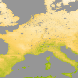
var dataset = ee.ImageCollection('MODIS/061/MYD16A2')\n .filter(ee.Filter.date('2021-01-01', '2021-02-01'));\nvar evapotranspiration = dataset.select('ET');\nvar evapotranspirationVis = {\n min: 0.0,\n max: 300.0,\n palette: [\n 'ffffff', 'fcd163', '99b718', '66a000', '3e8601', '207401', '056201',\n '004c00', '011301'\n ],\n};\nMap.setCenter(6.746, 46.529, 2);\nMap.addLayer(\n evapotranspiration, evapotranspirationVis, 'Evapotranspiration');\n```\n[Open in Code Editor](https://code.earthengine.google.com/?scriptPath=Examples:Datasets/MODIS/MODIS_061_MYD16A2) \n[MYD16A2.061: Aqua Net Evapotranspiration 8-Day L4 Global 500m SIN Grid V061](/earth-engine/datasets/catalog/MODIS_061_MYD16A2) \nThe MYD16A2 Version 6.1 Evapotranspiration/Latent Heat Flux product is an 8-day composite product at 500 meter pixel resolution. The algorithm used for the MOD16 data product collection is based on the logic of the Penman-Monteith equation, which includes inputs of daily meteorological reanalysis data along with MODIS remotely sensed data ... \nMODIS/061/MYD16A2, 8-day,evapotranspiration,global,modis,nasa,water-vapor \n2021-01-01T00:00:00Z/2025-08-13T00:00:00Z \n-90 -180 90 180 \nGoogle Earth Engine \nhttps://developers.google.com/earth-engine/datasets\n\n- [https://doi.org/10.5067/MODIS/MYD16A2.061](https://doi.org/https://doi.org/10.5067/MODIS/MYD16A2.061)\n- [https://doi.org/10.5067/MODIS/MYD16A2.061](https://doi.org/https://developers.google.com/earth-engine/datasets/catalog/MODIS_061_MYD16A2)"]]