- 데이터 세트 제공
- 2000-03-03T00:00:00Z–2025-12-01T00:00:00Z
- 데이터 세트 제공업체
- USGS EROS 센터 NASA LP DAAC
- 주기
- 1일
- 태그
설명
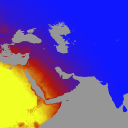
MCD18A1 버전 6.2는 3시간마다 DSR 추정치를 사용하여 1km 픽셀 해상도로 매일 생성되는 Moderate Resolution Imaging Spectroradiometer(MODIS) Terra 및 Aqua 결합 하향 단파 복사 (DSR) 그리드 레벨 3 제품입니다. DSR은 단파 스펙트럼 (300~4,000나노미터)에서 육지 표면에 대한 입사 태양 복사이며, 다양한 과학 및 애플리케이션 문제를 다루는 육지 표면 모델에서 중요한 변수입니다. MCD18 제품은 MODIS 데이터의 다중 시간 서명을 사용하여 표면 반사율을 도출한 다음 조회 테이블 (LUT) 접근 방식을 사용하여 입사 DSR을 계산하는 프로토타입 알고리즘을 기반으로 합니다. LUT는 다양한 조명/보기 지오메트리에서 다양한 유형의 에어로졸 및 구름 로딩을 고려합니다. 전역 DSR 제품은 MODIS 및 정지궤도 위성 데이터에서 생성됩니다. 데이터 생성에 사용된 방법론에 관한 자세한 내용은 알고리즘 이론적 근거 문서를 참고하세요.
대역
픽셀 크기
500m
대역
| 이름 | 단위 | 최소 | 최대 | 픽셀 크기 | 설명 | ||||||||||||||||||||||||||||||||||||||||||||||||||||||||||||||||||||||||||||||||||||||||||||||
|---|---|---|---|---|---|---|---|---|---|---|---|---|---|---|---|---|---|---|---|---|---|---|---|---|---|---|---|---|---|---|---|---|---|---|---|---|---|---|---|---|---|---|---|---|---|---|---|---|---|---|---|---|---|---|---|---|---|---|---|---|---|---|---|---|---|---|---|---|---|---|---|---|---|---|---|---|---|---|---|---|---|---|---|---|---|---|---|---|---|---|---|---|---|---|---|---|---|---|---|
DSR |
W/m^2 | 0 | 1400 | 미터 | MODIS 통과 시점의 순간 총 DSR |
||||||||||||||||||||||||||||||||||||||||||||||||||||||||||||||||||||||||||||||||||||||||||||||
Direct |
W/m^2 | 0 | 1400 | 미터 | MODIS 고가차도에서 즉각적인 직접 DSR |
||||||||||||||||||||||||||||||||||||||||||||||||||||||||||||||||||||||||||||||||||||||||||||||
Diffuse |
W/m^2 | 0 | 1400 | 미터 | MODIS 통과 시 순간적인 확산 DSR |
||||||||||||||||||||||||||||||||||||||||||||||||||||||||||||||||||||||||||||||||||||||||||||||
GMT_0000_DSR |
W/m^2 | 0 | 1400 | 미터 | GMT 00:00의 총 DSR |
||||||||||||||||||||||||||||||||||||||||||||||||||||||||||||||||||||||||||||||||||||||||||||||
GMT_0300_DSR |
W/m^2 | 0 | 1400 | 미터 | GMT 03:00의 총 DSR |
||||||||||||||||||||||||||||||||||||||||||||||||||||||||||||||||||||||||||||||||||||||||||||||
GMT_0600_DSR |
W/m^2 | 0 | 1400 | 미터 | GMT 06:00의 총 DSR |
||||||||||||||||||||||||||||||||||||||||||||||||||||||||||||||||||||||||||||||||||||||||||||||
GMT_0900_DSR |
W/m^2 | 0 | 1400 | 미터 | GMT 09:00의 총 DSR |
||||||||||||||||||||||||||||||||||||||||||||||||||||||||||||||||||||||||||||||||||||||||||||||
GMT_1200_DSR |
W/m^2 | 0 | 1400 | 미터 | GMT 12:00의 총 DSR |
||||||||||||||||||||||||||||||||||||||||||||||||||||||||||||||||||||||||||||||||||||||||||||||
GMT_1500_DSR |
W/m^2 | 0 | 1400 | 미터 | GMT 15:00의 총 DSR |
||||||||||||||||||||||||||||||||||||||||||||||||||||||||||||||||||||||||||||||||||||||||||||||
GMT_1800_DSR |
W/m^2 | 0 | 1400 | 미터 | GMT 18:00의 총 DSR |
||||||||||||||||||||||||||||||||||||||||||||||||||||||||||||||||||||||||||||||||||||||||||||||
GMT_2100_DSR |
W/m^2 | 0 | 1400 | 미터 | GMT 21:00의 총 DSR |
||||||||||||||||||||||||||||||||||||||||||||||||||||||||||||||||||||||||||||||||||||||||||||||
DSR_Quality |
미터 | 품질 플래그 |
|||||||||||||||||||||||||||||||||||||||||||||||||||||||||||||||||||||||||||||||||||||||||||||||||
이용약관
이용약관
LP DAAC를 통해 획득한 MODIS 데이터 및 제품은 후속 사용, 판매 또는 재배포에 제한이 없습니다.
인용
LP DAAC 데이터 세트 인용에 관한 자세한 내용은 LP DAAC '데이터 인용' 페이지를 참고하세요.
DOI
Earth Engine으로 탐색
코드 편집기(JavaScript)
var dataset = ee.ImageCollection('MODIS/062/MCD18A1')
                  .filter(ee.Filter.date('2000-01-01', '2001-01-01'));
var gmt_1200_dsr = dataset.select('GMT_1200_DSR');
var gmt_1200_dsr_vis = {
  min: 0,
  max: 350,
  palette: ['0f17ff', 'b11406', 'f1ff23'],
};
Map.setCenter(6.746, 46.529, 2);
Map.addLayer(
    gmt_1200_dsr, gmt_1200_dsr_vis,
    'Total dsr at GMT 12:00');