- Dataset-Verfügbarkeit
- 2000-02-24T00:00:00Z–2023-02-17T00:00:00Z
- Dataset-Anbieter
- Cadence
- 1 Tag
- Tags
Beschreibung
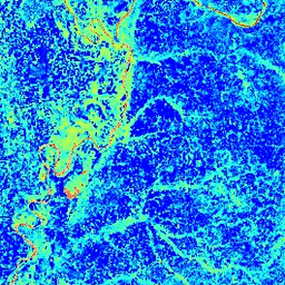
Der normierte differenzierte Wasserindex (Normalized Difference Water Index, NDWI) reagiert empfindlich auf Änderungen des Flüssigwassergehalts von Pflanzenbeständen. Er wird aus dem Nah-IR-Band und einem zweiten IR-Band abgeleitet, das bei Verfügbarkeit ≈1,24 μm beträgt, ansonsten das nächstgelegene verfügbare IR-Band. Die Werte reichen von -1,0 bis 1,0. Weitere Informationen finden Sie unter Gao (1996). Dieses Produkt wird aus den MODIS/006/MOD09GA-Oberflächenreflexionsverbundbildern generiert.
Bänder
Bänder
| Name | Pixelgröße | Beschreibung |
|---|---|---|
NDWI |
463.313 Meter | Normalisierter Differenz-Wasserindex |
Nutzungsbedingungen
Nutzungsbedingungen
Für MODIS-Daten und ‑Produkte, die über das LP DAAC erworben wurden, gelten keine Einschränkungen hinsichtlich der weiteren Verwendung, des Verkaufs oder der Weitergabe.
Earth Engine nutzen
Code-Editor (JavaScript)
var dataset = ee.ImageCollection('MODIS/MOD09GA_006_NDWI')
                  .filter(ee.Filter.date('2018-04-01', '2018-06-01'));
var colorized = dataset.select('NDWI');
var colorizedVis = {
  min: 0.0,
  max: 1.0,
  palette: ['0000ff', '00ffff', 'ffff00', 'ff0000', 'ffffff'],
};
Map.setCenter(-7.03125, 31.0529339857, 2);
Map.addLayer(colorized, colorizedVis, 'Colorized');