M2T1NXRAD (또는 tavg1_2d_rad_Nx)는 연구 및 애플리케이션 버전 2 (MERRA-2)를 위한 현대 시대 회고 분석의 시간 평균 데이터 컬렉션입니다. 이 컬렉션은 표면 태양광 반사율, 구름 면적 비율, 구름 내 광학 두께, 표면 입사 단파 플럭스 (즉, 태양 복사), 표면 순 하향 단파 플럭스, TOA (대기권 상단)에서의 상향 장파 플럭스(즉, TOA에서의 발산 장파 복사 (OLR))와 같은 복사 진단으로 구성됩니다. 데이터 필드에는 00:30 UTC부터 시작되는 시간의 중앙 시간이 타임스탬프로 표시됩니다.예를 들면 다음과 같습니다. 00:30, 01:30, ... , 23:30 UTC
MERRA-2는 Goddard Earth Observing System Model(GEOS) 버전 5.12.4를 사용하여 NASA Global Modeling and Assimilation Office (GMAO)에서 제작한 위성 시대의 최신 버전의 전역 대기 재분석입니다. 이 데이터 세트는 1980년부터 현재까지의 기간을 다루며, 월말 후 약 3주의 지연 시간이 있습니다.
대역
픽셀 크기 69375m
Y 픽셀 크기 55,000m
대역
이름
단위
최소
최대
픽셀 크기
설명
ALBEDO
0.01*
0.898471*
미터
표면 반사율
ALBNIRDF
0.017455*
0.820016*
미터
근적외선 확산의 표면 알베도
ALBNIRDR
0.018709*
0.82001*
미터
근적외선 빔의 표면 알베도
ALBVISDF
0.016788*
0.959771*
미터
표면 알베도(보이는 확산)
ALBVISDR
0.01853*
0.959762*
미터
가시광선 빔의 표면 알베도
CLDHGH
0*
0.999236*
미터
상층운의 구름 면적 비율
CLDLOW
0*
0.999997*
미터
하층운의 운량
CLDMID
0*
0.998779*
미터
중간 구름의 구름 면적 비율
CLDTOT
0*
1*
미터
총 구름 면적 비율
EMIS
0.943074*
0.999993*
미터
표면 방사율
LWGABCLRCLN
W/m^2
41.1408*
458.523*
미터
맑은 하늘과 에어로졸이 없다고 가정할 때 지표면에서 흡수된 장파 복사
LWGABCLR
W/m^2
41.1414*
465.929*
미터
맑은 하늘을 가정할 때 지표면이 흡수한 장파 복사
LWGAB
W/m^2
41.1446*
482.398*
미터
표면에서 흡수한 장파 복사
LWGEM
W/m^2
67.5297*
630.29*
미터
표면에서 방출되는 장파 복사
LWGNTCLRCLN
W/m^2
-248.748*
61.0736*
미터
맑은 하늘과 에어로졸이 없다고 가정할 때의 지표 순 하향 장파 복사 플럭스
LWGNTCLR
W/m^2
-248.653*
62.2794*
미터
맑은 하늘을 가정하는 지표면 순 하향 장파 복사
LWGNT
W/m^2
-268.862*
77.255*
미터
표면 순 하향 장파 복사
LWTUPCLRCLN
W/m^2
80.6768*
372.229*
미터
맑은 하늘과 에어로졸이 없다고 가정할 때 TOA에서의 상향 장파 복사 플럭스
LWTUPCLR
W/m^2
80.6768*
372.229*
미터
맑은 하늘을 가정할 때 TOA에서의 상향 장파 복사 플럭스
LWTUP
W/m^2
80.6506*
370.868*
미터
TOA에서의 상향 장파 복사 플럭스
SWGDNCLR
W/m^2
-0.008217*
1155.5*
미터
맑은 하늘을 가정하는 지표면 입사 단파 플럭스
SWGDN
W/m^2
0*
1127.49*
미터
표면 수신 단파 플럭스
SWGNTCLN
W/m^2
0*
1088.42*
미터
에어로졸이 없다고 가정할 때의 지표면 순 하향 단파 플럭스
SWGNTCLRCLN
W/m^2
-3.2e-05*
1088.42*
미터
맑은 하늘과 에어로졸이 없다고 가정할 때의 지표 순 하향 단파 복사
SWGNTCLR
W/m^2
-0.001333*
1083.95*
미터
맑은 하늘을 가정하는 표면 순 하향 단파 복사
SWGNT
W/m^2
0*
1083.95*
미터
표면 순 하향 단파 복사
SWTDN
W/m^2
0*
1404.28*
미터
TOA 수신 단파 플럭스
SWTNTCLN
W/m^2
0*
1315.89*
미터
에어로졸이 없다고 가정할 때 TOA 순 하향 단파 플럭스
SWTNTCLRCLN
W/m^2
0*
1317.5*
미터
맑은 하늘과 에어로졸이 없다고 가정할 때 TOA 순 하향 단파 플럭스
SWTNTCLR
W/m^2
0*
1316.5*
미터
맑은 하늘을 가정하는 TOA 순 하향 단파 복사
SWTNT
W/m^2
0*
1313.33*
미터
TOA 순 하향 단파 플럭스
TAUHGH
0*
142.188*
미터
높은 구름의 클라우드 광학 두께(내보내기)
TAULOW
0*
318.218*
미터
낮은 구름의 클라우드 광학 두께
TAUMID
0*
252.995*
미터
중간 구름의 클라우드 광학 두께
TAUTOT
0*
348.125*
미터
모든 구름의 광학 두께
TS
K
185.73*
328.864*
미터
표면 피부 온도
* 예상 최솟값 또는 최댓값
이용약관
이용약관
NASA는 연구 및 애플리케이션 커뮤니티, 민간 산업, 학계, 일반 대중과 모든 데이터를 완전하고 공개적으로 공유하도록 장려합니다.
M2T1NXRAD (또는 tavg1_2d_rad_Nx)는 Modern-Era Retrospective analysis for Research and Applications version 2 (MERRA-2)의 시간 평균 데이터 수집입니다. 이 컬렉션은 표면 태양광 반사율, 구름 면적 비율, 구름 내 광학 두께, 표면 입사 단파 플럭스 (즉, 태양 복사), 표면 순 하향 단파 플럭스 등 복사 진단으로 구성됩니다.
[null,null,[],[[["\u003cp\u003eThe NASA/GSFC/MERRA/rad/2 dataset provides hourly time-averaged radiation diagnostics from the Modern-Era Retrospective analysis for Research and Applications version 2 (MERRA-2).\u003c/p\u003e\n"],["\u003cp\u003eThis dataset includes measurements such as surface albedo, cloud area fraction, optical thickness, shortwave flux, and longwave flux.\u003c/p\u003e\n"],["\u003cp\u003eData is available from 1980 to near-present with a latency of approximately 3 weeks after the end of a month and is provided at a spatial resolution of 55,000 - 69,375 meters.\u003c/p\u003e\n"],["\u003cp\u003eNASA promotes open sharing of this data with research, industry, academia, and the public.\u003c/p\u003e\n"],["\u003cp\u003eThe data is easily accessible through Google Earth Engine using the provided Earth Engine Snippet.\u003c/p\u003e\n"]]],["The NASA/MERRA-2 dataset (M2T1NXRAD) provides hourly, time-averaged radiation diagnostics from 1980 to 2025, with a ~3-week latency. Data includes surface albedo, cloud fractions, optical thickness, and shortwave/longwave fluxes. It is produced by NASA GMAO using GEOS model version 5.12.4. Data is accessible via Google Earth Engine with specific bands available like ALBEDO, CLDHGH, SWGDN and more. Pixel size is 69375x55000 meters.\n"],null,["Dataset Availability\n: 1980-01-01T00:00:00Z--2025-08-01T23:00:00Z\n\nDataset Provider\n:\n\n\n [NASA/MERRA](https://gmao.gsfc.nasa.gov/reanalysis/MERRA-2/)\n\nCadence\n: 1 Hour\n\nTags\n:\n[albedo](/earth-engine/datasets/tags/albedo) [atmosphere](/earth-engine/datasets/tags/atmosphere) [climate](/earth-engine/datasets/tags/climate) [emissivity](/earth-engine/datasets/tags/emissivity) [merra](/earth-engine/datasets/tags/merra) [shortwave](/earth-engine/datasets/tags/shortwave) [temperature](/earth-engine/datasets/tags/temperature) \n\nDescription \nM2T1NXRAD (or tavg1_2d_rad_Nx) is an hourly time-averaged data\ncollection in Modern-Era Retrospective analysis for Research and\nApplications version 2 (MERRA-2). This collection consists of radiation\ndiagnostics, such as surface albedo, cloud area fraction, in cloud\noptical thickness, surface incoming shortwave flux (i.e. solar\nradiation), surface net downward shortwave flux, and upwelling longwave\nflux at TOA (top of atmosphere) (i.e. outgoing longwave radiation (OLR)\nat TOA). The data field is time-stamped with the central time of an hour\nstarting from 00:30 UTC, e.g.: 00:30, 01:30, ... , 23:30 UTC.\n\nMERRA-2 is the latest version of global atmospheric reanalysis for the\nsatellite era produced by NASA Global Modeling and Assimilation Office\n(GMAO) using the Goddard Earth Observing System Model (GEOS) version\n5.12.4. The dataset covers the period of 1980-present with the latency\nof \\~3 weeks after the end of a month.\n\nBands\n\n\n**Pixel Size**\n\n69375 meters\n\n\n**Y Pixel Size**\n\n55000 meters\n\n**Bands**\n\n| Name | Units | Min | Max | Pixel Size | Description |\n|---------------|--------|-------------|------------|------------|-----------------------------------------------------------------------|\n| `ALBEDO` | | 0.01\\* | 0.898471\\* | meters | Surface albedo |\n| `ALBNIRDF` | | 0.017455\\* | 0.820016\\* | meters | Surface albedo for near infrared diffuse |\n| `ALBNIRDR` | | 0.018709\\* | 0.82001\\* | meters | Surface albedo for near infrared beam |\n| `ALBVISDF` | | 0.016788\\* | 0.959771\\* | meters | Surface albedo for visible diffuse |\n| `ALBVISDR` | | 0.01853\\* | 0.959762\\* | meters | Surface albedo for visible beam |\n| `CLDHGH` | | 0\\* | 0.999236\\* | meters | Cloud area fraction for high clouds |\n| `CLDLOW` | | 0\\* | 0.999997\\* | meters | Cloud area fraction for low clouds |\n| `CLDMID` | | 0\\* | 0.998779\\* | meters | Cloud area fraction for middle clouds |\n| `CLDTOT` | | 0\\* | 1\\* | meters | Total cloud area fraction |\n| `EMIS` | | 0.943074\\* | 0.999993\\* | meters | Surface emissivity |\n| `LWGABCLRCLN` | W/m\\^2 | 41.1408\\* | 458.523\\* | meters | Surface absorbed longwave radiation assuming clear sky and no aerosol |\n| `LWGABCLR` | W/m\\^2 | 41.1414\\* | 465.929\\* | meters | Surface absorbed longwave radiation assuming clear sky |\n| `LWGAB` | W/m\\^2 | 41.1446\\* | 482.398\\* | meters | Surface absorbed longwave radiation |\n| `LWGEM` | W/m\\^2 | 67.5297\\* | 630.29\\* | meters | Longwave flux emitted from surface |\n| `LWGNTCLRCLN` | W/m\\^2 | -248.748\\* | 61.0736\\* | meters | Surface net downward longwave flux assuming clear sky and no aerosol |\n| `LWGNTCLR` | W/m\\^2 | -248.653\\* | 62.2794\\* | meters | Surface net downward longwave flux assuming clear sky |\n| `LWGNT` | W/m\\^2 | -268.862\\* | 77.255\\* | meters | Surface net downward longwave flux |\n| `LWTUPCLRCLN` | W/m\\^2 | 80.6768\\* | 372.229\\* | meters | Upwelling longwave flux at TOA assuming clear sky and no aerosol |\n| `LWTUPCLR` | W/m\\^2 | 80.6768\\* | 372.229\\* | meters | Upwelling longwave flux at TOA assuming clear sky |\n| `LWTUP` | W/m\\^2 | 80.6506\\* | 370.868\\* | meters | Upwelling longwave flux at TOA |\n| `SWGDNCLR` | W/m\\^2 | -0.008217\\* | 1155.5\\* | meters | Surface incoming shortwave flux assuming clear sky |\n| `SWGDN` | W/m\\^2 | 0\\* | 1127.49\\* | meters | Surface incoming shortwave flux |\n| `SWGNTCLN` | W/m\\^2 | 0\\* | 1088.42\\* | meters | Surface net downward shortwave flux assuming no aerosol |\n| `SWGNTCLRCLN` | W/m\\^2 | -3.2e-05\\* | 1088.42\\* | meters | Surface net downward shortwave flux assuming clear sky and no aerosol |\n| `SWGNTCLR` | W/m\\^2 | -0.001333\\* | 1083.95\\* | meters | Surface net downward shortwave flux assuming clear sky |\n| `SWGNT` | W/m\\^2 | 0\\* | 1083.95\\* | meters | Surface net downward shortwave flux |\n| `SWTDN` | W/m\\^2 | 0\\* | 1404.28\\* | meters | TOA incoming shortwave flux |\n| `SWTNTCLN` | W/m\\^2 | 0\\* | 1315.89\\* | meters | TOA net downward shortwave flux assuming no aerosol |\n| `SWTNTCLRCLN` | W/m\\^2 | 0\\* | 1317.5\\* | meters | TOA net downward shortwave flux assuming clear sky and no aerosol |\n| `SWTNTCLR` | W/m\\^2 | 0\\* | 1316.5\\* | meters | TOA net downward shortwave flux assuming clear sky |\n| `SWTNT` | W/m\\^2 | 0\\* | 1313.33\\* | meters | TOA net downward shortwave flux |\n| `TAUHGH` | | 0\\* | 142.188\\* | meters | In cloud optical thickness of high clouds(export) |\n| `TAULOW` | | 0\\* | 318.218\\* | meters | In cloud optical thickness of low clouds |\n| `TAUMID` | | 0\\* | 252.995\\* | meters | In cloud optical thickness of middle clouds |\n| `TAUTOT` | | 0\\* | 348.125\\* | meters | In cloud optical thickness of all clouds |\n| `TS` | K | 185.73\\* | 328.864\\* | meters | Surface skin temperature |\n\n\\* estimated min or max value\n\nTerms of Use\n\n**Terms of Use**\n\nNASA promotes the full and open sharing of all data with research and\napplications communities, private industry, academia, and the general\npublic.\n\nExplore with Earth Engine **Important:** Earth Engine is a platform for petabyte-scale scientific analysis and visualization of geospatial datasets, both for public benefit and for business and government users. Earth Engine is free to use for research, education, and nonprofit use. To get started, please [register for Earth Engine access.](https://console.cloud.google.com/earth-engine)\n\nCode Editor (JavaScript) \n\n```javascript\n
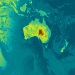
var dataset = ee.ImageCollection('NASA/GSFC/MERRA/rad/2')\n .filter(ee.Filter.date('2022-02-01', '2022-02-02')).first();\nvar surface_albedo = dataset.select('ALBEDO');\nvar saVis = {\n min: -0.428147,\n max: 0.833350,\n palette: ['001137', '01abab', 'e7eb05', '620500']\n};\nMap.setCenter(-95, 39, 2);\nMap.addLayer(surface_albedo, saVis, 'Surface albedo');\n```\n[Open in Code Editor](https://code.earthengine.google.com/?scriptPath=Examples:Datasets/NASA/NASA_GSFC_MERRA_rad_2) \n[MERRA-2 M2T1NXRAD: Radiation Diagnostics V5.12.4](/earth-engine/datasets/catalog/NASA_GSFC_MERRA_rad_2) \nM2T1NXRAD (or tavg1_2d_rad_Nx) is an hourly time-averaged data collection in Modern-Era Retrospective analysis for Research and Applications version 2 (MERRA-2). This collection consists of radiation diagnostics, such as surface albedo, cloud area fraction, in cloud optical thickness, surface incoming shortwave flux (i.e. solar radiation), surface net downward shortwave flux, and ... \nNASA/GSFC/MERRA/rad/2, albedo,atmosphere,climate,emissivity,merra,shortwave,temperature \n1980-01-01T00:00:00Z/2025-08-01T23:00:00Z \n-90 -180 90 180 \nGoogle Earth Engine \nhttps://developers.google.com/earth-engine/datasets\n\n- [](https://doi.org/https://gmao.gsfc.nasa.gov/reanalysis/MERRA-2/)\n- [](https://doi.org/https://developers.google.com/earth-engine/datasets/catalog/NASA_GSFC_MERRA_rad_2)"]]