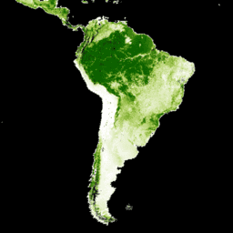
Landsat Vegetation Continuous Fields (VCF) 나무 덮개 레이어에는 높이가 5m를 초과하는 목본 식물로 덮인 각 30m 픽셀의 수평 지면 비율 추정치가 포함되어 있습니다. 이 데이터 세트는 2000년, 2005년, 2010년, 2015년을 중심으로 한 4개의 시대에 사용할 수 있습니다. 이 데이터 세트는 향상된 글로벌 토지 조사 (GLS) 데이터 세트를 기반으로 하는 GFCC 표면 반사율 제품 (GFCC30SR)에서 파생됩니다. GLS 데이터 세트는 30미터 해상도의 고해상도 Landsat 5 Thematic Mapper (TM) 및 Landsat 7 Enhanced Thematic Mapper Plus (ETM+) 이미지로 구성됩니다.
수목 피복은 특정 높이 이상의 목본 식물(잎, 줄기, 가지 등 포함)의 수직 투영 면적 비율로, 지상 에너지 및 물 교환, 광합성 및 증산, 순 일차 생산, 탄소 및 영양분 플럭스에 영향을 미칩니다. 수목 피복은 서식지 품질과 야생 동물의 이동, 인간의 주거용 부동산 가치, 기타 생태계 서비스에도 영향을 미칩니다. VCF 제품의 연속 분류 체계를 사용하면 기존의 불연속 분류 체계보다 토지 피복 경사를 더 잘 묘사할 수 있습니다.
산림 변화 (예: 삼림 벌채 및 황폐화)를 감지하고 모니터링하는 데 중요한 점은 수목 피복이 산림 피복과 그 변화를 정의하는 데 사용할 수 있는 측정 가능한 속성을 제공한다는 것입니다. 시간에 따른 나무 덮개의 변화를 사용하여 산림 변화의 사이트별 기록을 모니터링하고 검색할 수 있습니다.
데이터 세트는 2000년, 2005년, 2010년, 2015년의 4년 에포크에 대해 생성되었으며, 사용 가능한 각 WRS2 경로/행의 컬렉션에 이미지가 있습니다.
제공업체 참고사항: NASA MEaSUREs 기금이 종료되어 이 데이터 세트의 무료 버전이 더 이상 생성되지 않습니다. 관심이 있는 당사자는 www.terraPulse.com에서 업데이트되고 확장된 버전을 확인할 수 있습니다.
대역
픽셀 크기 30미터
대역
이름
단위
최소
최대
픽셀 크기
설명
tree_canopy_cover
%
0
100
미터
나무로 덮인 픽셀 면적의 비율입니다.
uncertainty
미터
tree-canopy_cover의 RMSE
source_index
미터
특정 픽셀에 사용된 소스 이미지의 ID입니다. 이미지별 메타데이터 배열 'sources'의 색인입니다. 2000년, 2005년, 2010년에만 사용할 수 있습니다.
이미지 속성
이미지 속성
이름
유형
설명
경로
DOUBLE
경로
pathrow
문자열
경로 및 행
행
DOUBLE
행
소스
DOUBLE
출처를 탭합니다. 2000년, 2005년, 2010년에만 사용할 수 있습니다.
tree_canopy_cover_class_palette
DOUBLE
트리 캐노피 범위 클래스 팔레트
tree_canopy_cover_class_values
DOUBLE
트리 캐노피 범위 클래스 값
년
DOUBLE
연도
이용약관
이용약관
이 데이터 세트의 지식 재산권은 University of Maryland, Department of Geographical Sciences 및 NASA에 있습니다. 출처를 표시하면 무료로 사용할 수 있습니다.
인용
인용:
논문/방법 인용: Sexton, J. O., Song, X.-P., Feng, M., Noojipady,
P., Anand, A., Huang, C., Kim, D.-H., Collins, K.M., Channan, S.,
DiMiceli, C., Townshend, J.R.G. (2013). 전역, 30m 해상도 연속 수목 피복 필드: LiDAR 기반 오류 추정치를 사용하여 MODIS 식생 연속 필드를 Landsat 기반으로 재조정
International Journal of Digital Earth, 130321031236007.
doi:10.1080/17538947.2013.786146.
Landsat Vegetation Continuous Fields (VCF) 수목 피복층에는 높이가 5m를 초과하는 목본 식물로 덮인 각 30m 픽셀의 수평 지면 비율 추정치가 포함되어 있습니다. 데이터 세트는 2000년, 2005년, 2010년, 2015년을 중심으로 4개의 에포크에 사용할 수 있습니다. 데이터 세트는 …
[null,null,[],[[["\u003cp\u003eThe NASA/MEASURES/GFCC/TC/v3 dataset provides estimates of tree canopy cover globally at 30-meter resolution, derived from Landsat imagery.\u003c/p\u003e\n"],["\u003cp\u003eData is available for four epochs centered on 2000, 2005, 2010, and 2015, representing the percentage of ground covered by woody vegetation over 5 meters tall.\u003c/p\u003e\n"],["\u003cp\u003eThe dataset is useful for monitoring forest change, habitat quality assessment, and studying various ecosystem services.\u003c/p\u003e\n"],["\u003cp\u003eFree versions are no longer being produced by NASA MEaSUREs, but updated versions are commercially available from TerraPulse.\u003c/p\u003e\n"],["\u003cp\u003eIntellectual property rights belong to the University of Maryland and NASA; usage is free with proper acknowledgement.\u003c/p\u003e\n"]]],[],null,["# Global Forest Cover Change (GFCC) Tree Cover Multi-Year Global 30m\n\nDataset Availability\n: 2000-01-01T00:00:00Z--2015-01-01T00:00:00Z\n\nDataset Provider\n:\n\n\n [NASA LP DAAC at the USGS EROS Center](https://doi.org/10.5067/MEaSUREs/GFCC/GFCC30TC.003)\n\nCadence\n: 5 Years\n\nTags\n:\n[forest](/earth-engine/datasets/tags/forest) [forest-biomass](/earth-engine/datasets/tags/forest-biomass) [glcf](/earth-engine/datasets/tags/glcf) [landsat-derived](/earth-engine/datasets/tags/landsat-derived) [nasa](/earth-engine/datasets/tags/nasa) [umd](/earth-engine/datasets/tags/umd) \n\n#### Description\n\nThe Landsat Vegetation Continuous Fields (VCF) tree cover layers contain\nestimates of the percentage of horizontal ground in each 30-m pixel covered\nby woody vegetation greater than 5 meters in height. The dataset is available\nfor four epochs centered on the years 2000, 2005, 2010 and 2015. The dataset\nis derived from the GFCC Surface Reflectance product (GFCC30SR), which is\nbased on enhanced Global Land Survey (GLS) datasets. The GLS datasets are\ncomposed of high-resolution Landsat 5 Thematic Mapper (TM) and Landsat 7\nEnhanced Thematic Mapper Plus (ETM+) images at 30 meter resolution.\n\nTree cover, the proportional, vertically projected area of vegetation\n(including leaves, stems, branches, etc.) of woody plants above a given\nheight, affects terrestrial energy and water exchanges, photosynthesis and\ntranspiration, net primary production, and carbon and nutrient fluxes. Tree\ncover also affects habitat quality and movements of wildlife, residential\nproperty value for humans, and other ecosystem services. The continuous\nclassification scheme of the VCF product enables better depiction of land\ncover gradients than traditional discrete classification schemes.\nImportantly for detection and monitoring of forest changes (e.g.,\ndeforestation and degradation), tree cover provides a measurable attribute\nupon which to define forest cover and its changes. Changes in tree cover\nover time can be used to monitor and retrieve site-specific histories of\nforest change.\n\nThe dataset has been produced for four year epochs: 2000, 2005, 2010, and\n2015 with an image in the collection for each available WRS2 path/row.\n\nDocumentation:\n\n- [User's guide](https://lpdaac.usgs.gov/documents/1371/GFCC_User_Guide_V1.pdf)\n\n- [Algorithm Theoretical Basis Document (ATBD)](https://lpdaac.usgs.gov/documents/1370/GFCC_ATBD.pdf)\n\nProvider's Note: Due to the end of NASA MEaSUREs funding, free versions of this dataset are no\nlonger being produced. Interested parties can obtain updated and expanded versions at\nwww.terraPulse.com.\n\n### Bands\n\n\n**Pixel Size**\n\n30 meters\n\n**Bands**\n\n| Name | Units | Min | Max | Pixel Size | Description |\n|---------------------|-------|-----|-----|------------|----------------------------------------------------------------------------------------------------------------------------------------------------------------|\n| `tree_canopy_cover` | % | 0 | 100 | meters | The percentage of pixel area covered by trees. |\n| `uncertainty` | | | | meters | RMSE for tree-canopy_cover |\n| `source_index` | | | | meters | Identity of source image used for the particular pixel. This is an index into the per image metadata array 'sources'. Only available for 2000, 2005, and 2010. |\n\n### Image Properties\n\n**Image Properties**\n\n| Name | Type | Description |\n|---------------------------------|--------|---------------------------------------------------|\n| path | DOUBLE | Path |\n| pathrow | STRING | Path and row |\n| row | DOUBLE | Row |\n| sources | DOUBLE | Sources. Only available for 2000, 2005, and 2010. |\n| tree_canopy_cover_class_palette | DOUBLE | Tree canopy cover class palette |\n| tree_canopy_cover_class_values | DOUBLE | Tree canopy cover class values |\n| year | DOUBLE | Year |\n\n### Terms of Use\n\n**Terms of Use**\n\nIntellectual property rights to this dataset belong to\nUniversity of Maryland, Department of Geographical Sciences and NASA. Usage\nis free if acklowedgement is made.\n\n### Citations\n\nCitations:\n\n- Paper/Methods Citation: Sexton, J. O., Song, X.-P., Feng, M., Noojipady,\n P., Anand, A., Huang, C., Kim, D.-H., Collins, K.M., Channan, S.,\n DiMiceli, C., Townshend, J.R.G. (2013). Global, 30-m resolution\n continuous fields of tree cover: Landsat-based rescaling of MODIS\n Vegetation Continuous Fields with lidar-based estimates of error.\n International Journal of Digital Earth, 130321031236007.\n [doi:10.1080/17538947.2013.786146](https://doi.org/10.1080/17538947.2013.786146).\n\n### DOIs\n\n- \u003chttps://doi.org/10.5067/MEaSUREs/GFCC/GFCC30TC.003\u003e\n\n### Explore with Earth Engine\n\n| **Important:** Earth Engine is a platform for petabyte-scale scientific analysis and visualization of geospatial datasets, both for public benefit and for business and government users. Earth Engine is free to use for research, education, and nonprofit use. To get started, please [register for Earth Engine access.](https://console.cloud.google.com/earth-engine)\n\n### Code Editor (JavaScript)\n\n```javascript\nvar dataset = ee.ImageCollection('NASA/MEASURES/GFCC/TC/v3')\n .filter(ee.Filter.date('2015-01-01', '2015-12-31'));\nvar treeCanopyCover = dataset.select('tree_canopy_cover');\nvar treeCanopyCoverVis = {\n min: 0.0,\n max: 100.0,\n palette: ['ffffff', 'afce56', '5f9c00', '0e6a00', '003800'],\n};\nMap.setCenter(-88.6, 26.4, 3);\nMap.addLayer(treeCanopyCover.mean(), treeCanopyCoverVis, 'Tree Canopy Cover');\n```\n[Open in Code Editor](https://code.earthengine.google.com/?scriptPath=Examples:Datasets/NASA/NASA_MEASURES_GFCC_TC_v3) \n[Global Forest Cover Change (GFCC) Tree Cover Multi-Year Global 30m](/earth-engine/datasets/catalog/NASA_MEASURES_GFCC_TC_v3) \nThe Landsat Vegetation Continuous Fields (VCF) tree cover layers contain estimates of the percentage of horizontal ground in each 30-m pixel covered by woody vegetation greater than 5 meters in height. The dataset is available for four epochs centered on the years 2000, 2005, 2010 and 2015. The dataset is ... \nNASA/MEASURES/GFCC/TC/v3, forest,forest-biomass,glcf,landsat-derived,nasa,umd \n2000-01-01T00:00:00Z/2015-01-01T00:00:00Z \n-90 -180 90 180 \nGoogle Earth Engine \nhttps://developers.google.com/earth-engine/datasets\n\n- [https://doi.org/10.5067/MEaSUREs/GFCC/GFCC30TC.003](https://doi.org/https://doi.org/10.5067/MEaSUREs/GFCC/GFCC30TC.003)\n- [https://doi.org/10.5067/MEaSUREs/GFCC/GFCC30TC.003](https://doi.org/https://developers.google.com/earth-engine/datasets/catalog/NASA_MEASURES_GFCC_TC_v3)"]]