NASA NEX-DCP30 데이터 세트는 결합 모델 비교 프로젝트 5단계 (CMIP5, Taylor et al. 2012 참고)에 따라 실행된 일반 순환 모델 (GCM)에서 파생되고 기후 변화에 관한 정부 간 패널 (IPCC AR5)의 5차 평가 보고서에 맞게 개발된 대표 농도 경로 (RCP, Meinshausen et al. 2011 참고)로 알려진 4가지 온실가스 배출 시나리오에 걸쳐 있는 미국 본토의 축소된 기후 시나리오로 구성됩니다. 이러한 데이터 세트의 목적은 미세한 규모의 기후 경사와 기후 조건에 대한 지역 지형의 영향을 민감하게 받는 프로세스에 대한 기후 변화 영향을 평가하는 데 사용할 수 있는 고해상도, 편향 보정 기후 변화 예측을 제공하는 것입니다.
데이터 세트에는 1950년부터 2005년까지 (회고적 실행) 및 2006년부터 2099년까지 (전망적 실행)의 기간을 포함하는 월별 예측이 포함되어 있습니다.
여기에는 33개 모델의 다운스케일링된 예측이 포함됩니다. 모든 시나리오에 모든 모델의 예측이 포함되는 것은 아닙니다.
NEX-DCP30은 NASA Earth Exchange를 사용하여 Climate Analytics Group과 NASA Ames Research Center에서 준비했으며 NASA Center for Climate Simulation (NCCS)에서 배포했습니다.
대역
픽셀 크기 927.67미터
대역
이름
단위
최소
최대
픽셀 크기
설명
pr
kg/m^2/s
0*
0.0016*
미터
표면에서의 일일 강수량의 월별 평균입니다. 모든 유형의 구름(대규모 및 대류)에서 발생하는 액체 및 고체 단계가 모두 포함됩니다.
tasmin
K
235.91*
308.97*
미터
일일 최저 지표면 기온의 월별 평균
tasmax
K
246.4*
325.53*
미터
일일 최대 지표면 기온의 월별 평균
* 예상 최솟값 또는 최댓값
이미지 속성
이미지 속성
이름
유형
설명
시나리오
문자열
CMIP5 시나리오의 이름입니다. 'historical', 'rcp26', 'rcp45', 'rcp60', 'rcp85' 중 하나입니다. 여기서 'historical'은 회고 모델 실행 (2006년 이전)을 나타냅니다.
Thrasher, B., J. Xiong, W. Wang, F. Melton, A. Michaelis 및 R. Nemani
(2013), Downscaled Climate Projections Suitable for Resource Management,
Eos Trans. AGU, 94(37), 321.
doi:10.1002/2013EO370002
NASA NEX-DCP30 데이터 세트는 접합 대순환 모델 5 (CMIP5, Taylor et al. 2012 참고)에 따라 실행된 일반 순환 모델 (GCM)에서 파생되고 …로 알려진 4가지 온실가스 배출 시나리오에 걸쳐 있는 미국 본토의 다운스케일링된 기후 시나리오로 구성됩니다.
[null,null,[],[[["\u003cp\u003eNEX-DCP30 provides downscaled climate projections for the conterminous United States, derived from CMIP5 models and RCP scenarios.\u003c/p\u003e\n"],["\u003cp\u003eThe dataset includes monthly projections of precipitation and temperature from 1950 to 2099 at a 927-meter resolution.\u003c/p\u003e\n"],["\u003cp\u003eProjections are available for 33 climate models and four greenhouse gas emissions scenarios (RCPs).\u003c/p\u003e\n"],["\u003cp\u003eNEX-DCP30 was developed by the Climate Analytics Group and NASA, and is freely available for use and distribution.\u003c/p\u003e\n"],["\u003cp\u003eData can be accessed and analyzed using Google Earth Engine.\u003c/p\u003e\n"]]],["The NASA NEX-DCP30 dataset provides downscaled climate projections for the US from 1950 to 2099, derived from CMIP5 GCM runs and IPCC AR5 emissions scenarios. The data, available monthly, includes precipitation rate (`pr`), minimum (`tasmin`) and maximum (`tasmax`) air temperature. It offers projections from 33 models, across historical and future scenarios. The dataset is accessible via the Earth Engine with the snippet: `ee.ImageCollection(\"NASA/NEX-DCP30\")` and is in the public domain.\n"],null,["# NEX-DCP30: NASA Earth Exchange Downscaled Climate Projections\n\nDataset Availability\n: 1950-01-01T00:00:00Z--2099-12-01T00:00:00Z\n\nDataset Provider\n:\n\n\n [NASA / Climate Analytics Group](https://www.nccs.nasa.gov/services/data-collections/land-based-products/nex-dcp30)\n\nCadence\n: 1 Month\n\nTags\n:\n[cag](/earth-engine/datasets/tags/cag) [climate](/earth-engine/datasets/tags/climate) [cmip5](/earth-engine/datasets/tags/cmip5) [geophysical](/earth-engine/datasets/tags/geophysical) [ipcc](/earth-engine/datasets/tags/ipcc) [nasa](/earth-engine/datasets/tags/nasa) [nex](/earth-engine/datasets/tags/nex) [precipitation](/earth-engine/datasets/tags/precipitation) [temperature](/earth-engine/datasets/tags/temperature) \n\n#### Description\n\nThe NASA NEX-DCP30 dataset is comprised of downscaled climate scenarios\nfor the conterminous United States that are derived from the General\nCirculation Model (GCM) runs conducted under the Coupled Model\nIntercomparison Project Phase 5 (CMIP5, see [Taylor et al. 2012](https://journals.ametsoc.org/doi/abs/10.1175/BAMS-D-11-00094.1))\nand across the four greenhouse gas emissions scenarios known as\nRepresentative Concentration Pathways (RCPs, see [Meinshausen et al. 2011](https://rd.springer.com/article/10.1007%2Fs10584-011-0156-z#page-1))\ndeveloped for the Fifth Assessment Report of the Intergovernmental Panel\non Climate Change (IPCC AR5). The purpose of these datasets is to provide\na set of high resolution, bias-corrected climate change projections that\ncan be used to evaluate climate change impacts on processes that are\nsensitive to finer-scale climate gradients and the effects of local\ntopography on climate conditions.\n\nThe dataset contains monthly projections covering the periods from 1950\nthrough 2005 (Retrospective Run) and from 2006 to 2099 (Prospective Run).\nIt includes downscaled projections from 33 models. Not every\nscenario contains projections from every model.\n\nNEX-DCP30 was prepared by the Climate Analytics Group and NASA Ames\nResearch Center using the NASA Earth Exchange, and distributed by the NASA\nCenter for Climate Simulation (NCCS).\n\n### Bands\n\n\n**Pixel Size**\n\n927.67 meters\n\n**Bands**\n\n| Name | Units | Min | Max | Pixel Size | Description |\n|----------|-----------|----------|----------|------------|-----------------------------------------------------------------------------------------------------------------------------------------------------------|\n| `pr` | kg/m\\^2/s | 0\\* | 0.0016\\* | meters | Monthly mean of the daily precipitation rate at surface; includes both liquid and solid phases from all types of clouds (both large-scale and convective) |\n| `tasmin` | K | 235.91\\* | 308.97\\* | meters | Monthly mean of the daily-minimum near-surface air temperature |\n| `tasmax` | K | 246.4\\* | 325.53\\* | meters | Monthly mean of the daily-maximum near-surface air temperature |\n\n\\* estimated min or max value\n\n### Image Properties\n\n**Image Properties**\n\n| Name | Type | Description |\n|----------|--------|----------------------------------------------------------------------------------------------------------------------------------------------------------------------------------------------------------------------------------------------------------------------------------------------------------------------------------------------------------------------------------------------------------------------------------------------------------------------------------------------------|\n| scenario | STRING | Name of the CMIP5 scenario. It is one of: 'historical', 'rcp26', 'rcp45', 'rcp60', 'rcp85', where 'historical' designates retrospective model runs (pre-2006). |\n| model | STRING | Name of the CMIP5 model. It is one of 'ACCESS1-0', 'bcc-csm1-1', 'bcc-csm1-1-m', 'BNU-ESM', 'CanESM2', 'CCSM4', 'CESM1-BGC', 'CESM1-CAM5', 'CMCC-CM', 'CNRM-CM5', 'CSIRO-Mk3-6-0', 'FGOALS-g2', 'FIO-ESM', 'GFDL-CM3', 'GFDL-ESM2G', 'GFDL-ESM2M', 'GISS-E2-H-CC', 'GISS-E2-R', 'GISS-E2-R-CC', 'HadGEM2-AO', 'HadGEM2-CC', 'HadGEM2-ES', 'inmcm4', 'IPSL-CM5A-LR', 'IPSL-CM5A-MR', 'IPSL-CM5B-LR', 'MIROC5', 'MIROC-ESM', 'MIROC-ESM-CHEM', 'MPI-ESM-LR', 'MPI-ESM-MR', 'MRI-CGCM3', 'NorESM1-M'. |\n| metric | DOUBLE | Calendar month |\n\n### Terms of Use\n\n**Terms of Use**\n\nThis dataset is in the public domain and is available\nwithout restriction on use and distribution. See [NASA's\nEarth Science Data \\& Information Policy](https://www.earthdata.nasa.gov/engage/open-data-services-and-software/data-and-information-policy)\nfor additional information.\n\n### Citations\n\nCitations:\n\n- Thrasher, B., J. Xiong, W. Wang, F. Melton, A. Michaelis and R. Nemani\n (2013), Downscaled Climate Projections Suitable for Resource Management,\n Eos Trans. AGU, 94(37), 321.\n [doi:10.1002/2013EO370002](https://doi.org/10.1002/2013EO370002)\n\n### Explore with Earth Engine\n\n| **Important:** Earth Engine is a platform for petabyte-scale scientific analysis and visualization of geospatial datasets, both for public benefit and for business and government users. Earth Engine is free to use for research, education, and nonprofit use. To get started, please [register for Earth Engine access.](https://console.cloud.google.com/earth-engine)\n\n### Code Editor (JavaScript)\n\n```javascript\n
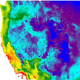
var dataset = ee.ImageCollection('NASA/NEX-DCP30')\n .filter(ee.Filter.date('2018-07-01', '2018-07-30'));\nvar minimumAirTemperature = dataset.select('tasmin');\nvar minimumAirTemperatureVis = {\n min: 265.0,\n max: 285.0,\n palette: ['blue', 'purple', 'cyan', 'green', 'yellow', 'red'],\n};\nMap.setCenter(-115.356, 38.686, 5);\nMap.addLayer(\n minimumAirTemperature, minimumAirTemperatureVis, 'Minimum Air Temperature');\n```\n[Open in Code Editor](https://code.earthengine.google.com/?scriptPath=Examples:Datasets/NASA/NASA_NEX-DCP30) \n[NEX-DCP30: NASA Earth Exchange Downscaled Climate Projections](/earth-engine/datasets/catalog/NASA_NEX-DCP30) \nThe NASA NEX-DCP30 dataset is comprised of downscaled climate scenarios for the conterminous United States that are derived from the General Circulation Model (GCM) runs conducted under the Coupled Model Intercomparison Project Phase 5 (CMIP5, see Taylor et al. 2012) and across the four greenhouse gas emissions scenarios known as ... \nNASA/NEX-DCP30, cag,climate,cmip5,geophysical,ipcc,nasa,nex,precipitation,temperature \n1950-01-01T00:00:00Z/2099-12-01T00:00:00Z \n24.07 -125.03 53.74 -66.47 \nGoogle Earth Engine \nhttps://developers.google.com/earth-engine/datasets\n\n- [](https://doi.org/https://www.nccs.nasa.gov/services/data-collections/land-based-products/nex-dcp30)\n- [](https://doi.org/https://developers.google.com/earth-engine/datasets/catalog/NASA_NEX-DCP30)"]]