- 데이터 세트 제공
- 2012-01-19T00:00:00Z–2025-12-19T00:00:00Z
- 데이터 세트 제공업체
- USGS EROS 센터 NASA LP DAAC
- 주기
- 1일
- 태그
설명
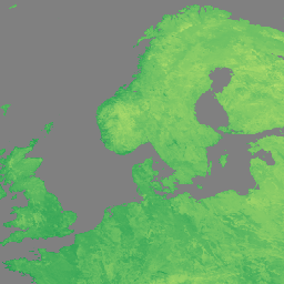
NASA Suomi National Polar-Orbiting Partnership (Suomi NPP) Visible Infrared Imaging Radiometer Suite (VIIRS) Land Surface Temperature and Emissivity (LST&E) Day Version 1 제품 (VNP21A1D)은 주간 Level 2 Gridded (L2G) 중간 제품에서 매일 컴파일됩니다.
L2G 프로세스는 일일 VNP21 스와스 과립을 시뉴소이드 MODIS 그리드에 매핑하고 지정된 날짜의 그리드 셀과 겹치는 모든 관측치를 저장합니다. VNP21A1 알고리즘은 각 셀에 대해 이러한 모든 관측치를 정렬하고 LST 정확도가 우수한 모든 클라우드 없는 관측치의 평균으로 최종 LST 값을 추정합니다. 관측 범위가 특정 기준점 (15%)을 초과하는 관측치만 이 평균에 고려됩니다.
문서:
대역
픽셀 크기
1,000미터
대역
| 이름 | 단위 | 픽셀 크기 | 설명 | ||||||||||||||||||||||||||||||||||||||||||||||||||||||||||||||||||||||||||||||||||||||||||||||||
|---|---|---|---|---|---|---|---|---|---|---|---|---|---|---|---|---|---|---|---|---|---|---|---|---|---|---|---|---|---|---|---|---|---|---|---|---|---|---|---|---|---|---|---|---|---|---|---|---|---|---|---|---|---|---|---|---|---|---|---|---|---|---|---|---|---|---|---|---|---|---|---|---|---|---|---|---|---|---|---|---|---|---|---|---|---|---|---|---|---|---|---|---|---|---|---|---|---|---|---|
LST_1KM |
K | 미터 | 일일 1km 지표면 온도입니다. |
||||||||||||||||||||||||||||||||||||||||||||||||||||||||||||||||||||||||||||||||||||||||||||||||
QC |
미터 | LST 및 방사율의 일일 품질 관리 |
|||||||||||||||||||||||||||||||||||||||||||||||||||||||||||||||||||||||||||||||||||||||||||||||||
Emis_14 |
미터 | 일일 M14 방사율 |
|||||||||||||||||||||||||||||||||||||||||||||||||||||||||||||||||||||||||||||||||||||||||||||||||
Emis_15 |
미터 | 일일 M15 방사율 |
|||||||||||||||||||||||||||||||||||||||||||||||||||||||||||||||||||||||||||||||||||||||||||||||||
Emis_16 |
미터 | 일일 M16 방사율 |
|||||||||||||||||||||||||||||||||||||||||||||||||||||||||||||||||||||||||||||||||||||||||||||||||
View_Angle |
deg | 미터 | LST의 천정각 보기 |
||||||||||||||||||||||||||||||||||||||||||||||||||||||||||||||||||||||||||||||||||||||||||||||||
View_Time |
h | 미터 | LST 관측 시간 |
||||||||||||||||||||||||||||||||||||||||||||||||||||||||||||||||||||||||||||||||||||||||||||||||
이용약관
이용약관
LP DAAC NASA 데이터는 자유롭게 액세스할 수 있지만, 저자가 이러한 데이터를 게시하거나 데이터를 기반으로 작업할 때는 저자가 게시물의 텍스트 내에서 데이터세트를 인용하고 참고 문헌 목록에 데이터세트를 포함해야 합니다.
인용
인용
LP DAAC 데이터 세트 인용에 관한 자세한 내용은 LP DAAC '데이터 인용' 페이지를 참고하세요.
DOI
Earth Engine으로 탐색
코드 편집기(JavaScript)
var dataset = ee.ImageCollection('NASA/VIIRS/002/VNP21A1D')
                  .filter(ee.Filter.date('2022-11-01', '2022-12-01'));

var visualization = {
  bands: ['LST_1KM'],
  min: [150],
  max: [300],
  palette: [
    'a50026',
    'd73027',
    'f46d43',
    'fdae61',
    'fee08b',
    'ffffbf',
    'd9ef8b',
    'a6d96a',
    '66bd63',
    '1a9850',
    '006837',
  ]
};
Map.setCenter(41.2, 38.84, 3);
Map.addLayer(dataset, visualization, 'LST');