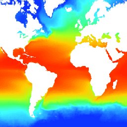
NOAA 1/4도 일일 최적 보간 해수면 온도(OISST)는 다양한 플랫폼 (위성, 선박, 부표)에서 편향 조정된 관측치를 정기적인 전역 그리드에 결합하여 구성된 완전한 해양 온도 필드를 제공하며, 간격은 보간으로 채워집니다.
Advanced Very High Resolution Radiometer (AVHRR)의 위성 데이터는 1981년 말부터 현재까지 높은 시간-공간 범위를 허용하는 주요 입력을 제공합니다.
OISST 데이터 세트에는 하루의 데이터가 두 번 처리되어 있습니다. 먼저 1일의 지연 시간이 있는 거의 실시간 예비 버전이 출시되고 14일의 지연 시간이 있는 최종 버전이 출시됩니다. 최종 버전은 예비 버전을 대체하는 것 외에도 스무딩을 위한 추가 일수와 구역 편향 보정을 사용합니다.
대역
픽셀 크기 27830m
대역
이름
단위
최소
최대
확장
픽셀 크기
설명
sst
°C
-180*
3764*
0.01
미터
일일 해수면 온도
anom
°C
-1887*
1902*
0.01
미터
온도 이상치: 일일 OISST에서 30년 기후학적 평균을 뺀 값입니다.
ice
%
1*
100*
0.01
미터
일일 해빙 농도의 7일 중앙값입니다.
err
°C
11*
171*
0.01
미터
예상 오류, 분석된 해수면 온도의 표준 편차입니다.
* 예상 최솟값 또는 최댓값
이미지 속성
이미지 속성
이름
유형
설명
상태
문자열
'provisional' 또는 'permanent'
이용약관
이용약관
CDR의 NOAA CDR 프로그램 공식 배포 지점은 NOAA의 국립 기후 데이터 센터입니다. 이 센터는 대통령의 '공개 데이터 정책'에 관한 메모에 설명되어 있고 2013년 5월 9일의 행정 명령 '정부 정보의 새로운 기본값으로 공개 및 기계 판독 가능 설정'에 따라 미국의 공개 데이터 정책 및 관행을 준수하여 CDR 패키지 및 관련 정보에 대한 지속적이고 개방적인 액세스와 적극적인 데이터 관리를 제공합니다. 이러한 정책에 따라 CDR 데이터 세트는 독점적이지 않고 공개적으로 제공되며 사용에 제한이 없습니다. 자세한 내용은 NOAA의 CDR 데이터 세트, 알고리즘, 문서의 공정 사용 PDF를 참고하세요.
인용
인용:
리처드 W. Reynolds, Viva F. Banzon, NOAA CDR 프로그램 (2008): NOAA 최적 보간 1/4도 일일 해수면 온도 (OISST) 분석, 버전 2. [사용된 하위 집합을 나타냅니다.] NOAA National Centers for Environmental Information. doi:10.7289/V5SQ8XB5[액세스 날짜].
NOAA 1/4도 일일 최적 보간 해수면 온도 (OISST)는 다양한 플랫폼 (위성, 선박, 부표)에서 편향 조정된 관측치를 정규 전역 그리드에 결합하여 구성된 완전한 해양 온도 필드를 제공하며, 간격은 보간으로 채워집니다. 고해상도 고급 방사계 (AVHRR)의 위성 데이터는 …
[null,null,[],[[["\u003cp\u003eThe NOAA CDR OISST V2.1 dataset provides daily sea surface temperature (SST) data from September 1981 to present, combining observations from satellites, ships, and buoys.\u003c/p\u003e\n"],["\u003cp\u003eIt includes sea surface temperature, temperature anomaly, sea ice concentration, and estimated error bands, at a 1/4 degree resolution.\u003c/p\u003e\n"],["\u003cp\u003eBoth preliminary (near real-time) and final versions of data are available, with the final version incorporating additional smoothing and bias correction.\u003c/p\u003e\n"],["\u003cp\u003eThe dataset is freely available for research, education, and non-profit use with no restrictions.\u003c/p\u003e\n"],["\u003cp\u003eOISST relies primarily on satellite data from the Advanced Very High Resolution Radiometer (AVHRR) to achieve comprehensive temporal and spatial coverage.\u003c/p\u003e\n"]]],[],null,["Dataset Availability\n: 1981-09-01T00:00:00Z--2025-08-27T00:00:00Z\n\nDataset Provider\n:\n\n\n [NOAA](https://www.ncei.noaa.gov/products/optimum-interpolation-sst)\n\nCadence\n: 1 Day\n\nTags\n:\n [avhrr](/earth-engine/datasets/tags/avhrr) [cdr](/earth-engine/datasets/tags/cdr) [daily](/earth-engine/datasets/tags/daily) [ice](/earth-engine/datasets/tags/ice) [noaa](/earth-engine/datasets/tags/noaa) [ocean](/earth-engine/datasets/tags/ocean) [oceans](/earth-engine/datasets/tags/oceans) [oisst](/earth-engine/datasets/tags/oisst) [sst](/earth-engine/datasets/tags/sst) [temperature](/earth-engine/datasets/tags/temperature) \nreal-time \n\nDescription \nThe NOAA 1/4 degree daily Optimum Interpolation Sea Surface Temperature\n(OISST) provides complete ocean temperature fields constructed by combining\nbias-adjusted observations from different platforms (satellite, ships,\nbuoys) on a regular global grid, with gaps filled in by interpolation.\nSatellite data from the Advanced Very High Resolution Radiometer (AVHRR)\nprovides the main input which permits the high temporal-spatial coverage\nbeginning in late 1981 to the present.\n\nThe OISST dataset has a single day's data processed twice. First a near\nreal-time preliminary version is released with a lag of 1 day, and a final\nversion with a lag of 14 days. The final version uses extra days for\nsmoothing, and zonal bias correction in addition to replacing the\npreliminary version.\n\nBands\n\n\n**Pixel Size**\n\n27830 meters\n\n**Bands**\n\n| Name | Units | Min | Max | Scale | Pixel Size | Description |\n|--------|-------|---------|--------|-------|------------|---------------------------------------------------------------------------|\n| `sst` | °C | -180\\* | 3764\\* | 0.01 | meters | Daily sea surface temperature |\n| `anom` | °C | -1887\\* | 1902\\* | 0.01 | meters | Temperature anomaly; the daily OISST minus a 30-year climatological mean. |\n| `ice` | % | 1\\* | 100\\* | 0.01 | meters | Seven-day median of daily sea ice concentrations. |\n| `err` | °C | 11\\* | 171\\* | 0.01 | meters | Estimated error; standard deviation of analyzed sea surface temperature. |\n\n\\* estimated min or max value\n\nImage Properties\n\n**Image Properties**\n\n| Name | Type | Description |\n|--------|--------|------------------------------|\n| status | STRING | 'provisional' or 'permanent' |\n\nTerms of Use\n\n**Terms of Use**\n\nThe NOAA CDR Program's official distribution point for CDRs is NOAA's\nNational Climatic Data Center which provides sustained, open access and\nactive data management of the CDR packages and related information in\nkeeping with the United States' open data policies and practices as\ndescribed in the President's Memorandum on \"Open Data Policy\" and pursuant\nto the Executive Order of May 9, 2013, \"Making Open and Machine Readable\nthe New Default for Government Information\". In line with these policies,\nthe CDR data sets are nonproprietary, publicly available, and no\nrestrictions are placed upon their use. For more information, see the\n[Fair Use of NOAA's CDR Data Sets, Algorithms and Documentation](https://www1.ncdc.noaa.gov/pub/data/sds/cdr/CDRs/Aerosol_Optical_Thickness/UseAgreement_01B-04.pdf)\npdf.\n\nCitations \nCitations:\n\n- Richard W. Reynolds, Viva F. Banzon, and NOAA CDR Program (2008): NOAA\n Optimum Interpolation 1/4 Degree Daily Sea Surface Temperature (OISST)\n Analysis, Version 2. \\[indicate subset used\\]. NOAA National Centers for\n Environmental Information. [doi:10.7289/V5SQ8XB5](https://doi.org/10.7289/V5SQ8XB5)\n \\[access date\\].\n\nDOIs\n\n- \u003chttps://doi.org/10.7289/V5SQ8XB5\u003e\n\nExplore with Earth Engine **Important:** Earth Engine is a platform for petabyte-scale scientific analysis and visualization of geospatial datasets, both for public benefit and for business and government users. Earth Engine is free to use for research, education, and nonprofit use. To get started, please [register for Earth Engine access.](https://console.cloud.google.com/earth-engine)\n\nCode Editor (JavaScript) \n\n```javascript\nvar dataset = ee.ImageCollection('NOAA/CDR/OISST/V2_1')\n .filter(ee.Filter.date('2017-05-01', '2017-05-14'));\nvar seaSurfaceTemperature = dataset.select('sst');\nvar visParams = {\n min: -180.0,\n max: 3000.0,\n palette: [\n '040274', '040281', '0502a3', '0502b8', '0502ce', '0502e6',\n '0602ff', '235cb1', '307ef3', '269db1', '30c8e2', '32d3ef',\n '3be285', '3ff38f', '86e26f', '3ae237', 'b5e22e', 'd6e21f',\n 'fff705', 'ffd611', 'ffb613', 'ff8b13', 'ff6e08', 'ff500d',\n 'ff0000', 'de0101', 'c21301', 'a71001', '911003'\n ],\n};\nMap.setCenter(20.3, -20.39, 2);\nMap.addLayer(seaSurfaceTemperature, visParams, 'Sea Surface Temperature');\n```\n[Open in Code Editor](https://code.earthengine.google.com/?scriptPath=Examples:Datasets/NOAA/NOAA_CDR_OISST_V2_1) \n[NOAA CDR OISST v02r01: Optimum Interpolation Sea Surface Temperature](/earth-engine/datasets/catalog/NOAA_CDR_OISST_V2_1) \nThe NOAA 1/4 degree daily Optimum Interpolation Sea Surface Temperature (OISST) provides complete ocean temperature fields constructed by combining bias-adjusted observations from different platforms (satellite, ships, buoys) on a regular global grid, with gaps filled in by interpolation. Satellite data from the Advanced Very High Resolution Radiometer (AVHRR) provides the ... \nNOAA/CDR/OISST/V2_1, avhrr,cdr,daily,ice,noaa,ocean,oceans,oisst,sst,temperature \n1981-09-01T00:00:00Z/2025-08-27T00:00:00Z \n-90 -180 90 180 \nGoogle Earth Engine \nhttps://developers.google.com/earth-engine/datasets\n\n- [https://doi.org/10.7289/V5SQ8XB5](https://doi.org/https://www.ncei.noaa.gov/products/optimum-interpolation-sst)\n- [https://doi.org/10.7289/V5SQ8XB5](https://doi.org/https://developers.google.com/earth-engine/datasets/catalog/NOAA_CDR_OISST_V2_1)"]]