- 데이터 세트 제공
- 1979-01-01T00:00:00Z–2025-12-16T00:00:00Z
- 데이터 세트 제공업체
- NOAA 물리 과학 연구소
- 태그
설명
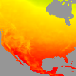
이 데이터 세트는 일일 최고 기온 (Tmax), 최저 기온 (Tmin)을 비롯한 전 세계 육지 지역의 일일 지표면 공기 온도의 그리드 분석을 제공합니다. 1979년부터 현재까지의 데이터는 CPC의 게이지 기반 전 세계 일일 강수량 분석의 해상도에 맞춰 0.5도 위도/경도 그리드로 표시됩니다. 이 데이터 세트의 구성은 지형 효과를 고려합니다. 주요 목적은 기후 모니터링 및 예측 확인 활동을 지원하는 것입니다. 입력 데이터는 GTS (Global Telecommunication System) 일일 보고서의 CPC 보관 파일에서 가져오며, 전 세계 약 6,000~7,000개 지점의 Tmax 및 Tmin 데이터를 통합합니다.
기술 문서는 여기를 참고하세요.
대역
픽셀 크기
55,500미터
대역
| 이름 | 단위 | 최소 | 최대 | 픽셀 크기 | 설명 |
|---|---|---|---|---|---|
tmax |
°C | -89.84* | 66.03* | 미터 | 일일 최고 온도 |
tmin |
°C | -97.92* | 54.26* | 미터 | 일일 최저 온도 |
nmax |
0* | 7* | 미터 | 최고 기온 보고 횟수 |
|
nmin |
0* | 7* | 미터 | 최저 온도 보고 수 |
이용약관
이용약관
NOAA CPC 데이터 세트는 사용 또는 배포에 제한이 없습니다. NOAA PSL은 사용자가 적절한 출처 표시를 제공하고 해당되는 경우 NOAA PSL을 데이터 소스로 식별하도록 요청합니다.
Earth Engine으로 탐색
코드 편집기(JavaScript)
var dataset = ee.ImageCollection('NOAA/CPC/Temperature').filter(ee.Filter.date('2018-01-01', '2019-01-01'));
var temperature = dataset.select('tmax');
var temperatureVis = {
  min: -40,
  max: 50,
  palette: ['#ADD8E6', '#008000', '#FFFF00', '#FFA500', '#FF0000', '#800080'],
};
Map.setCenter(-104.8, 49.1, 3);
Map.addLayer(temperature, temperatureVis, 'NOAA CPC Temperature');