- 데이터 세트 제공
- 2015-07-01T00:00:00Z–2025-12-17T18:00:00Z
- 데이터 세트 제공업체
- NOAA/NCEP/EMC
- 주기
- 6시간
- 태그
설명
Global Forecast System (GFS)은 국립 환경 예측 센터 (NCEP)에서 생성하는 일기예보 모델입니다. GFS 데이터 세트는 그리드 형식의 예측 변수로 선택된 모델 출력 (아래 설명)으로 구성됩니다. 1시간 (최대 120시간) 및 3시간 (120시간 이후) 예측 간격의 384시간 예측은 6시간 시간 해상도로 이루어집니다 (즉, 하루에 네 번 업데이트됨). 'creation_time' 및 'forecast_time' 속성을 사용하여 관심 있는 데이터를 선택합니다.
GFS는 대기 모델, 해양 모델, 육지/토양 모델, 해빙 모델로 구성된 결합 모델로, 이러한 모델이 함께 작동하여 정확한 날씨 상황을 제공합니다. 이 모델은 변경될 수 있습니다. 자세한 내용은 최근 전역 예측/분석 시스템 수정 기록 및 문서를 참고하세요. 시간별 및 일별 변동이 클 수 있으므로 분석 전에 대역에 노이즈 감소 기술을 적용해야 합니다.
사용 가능한 예측 시간과 간격은 시간에 따라 변경되었습니다.
- 2015년 4월 1일~2017년 7월 9일: 3시간 간격으로 0시를 제외한 36시간 예보
- 2017년 7월 9일~2021년 6월 11일: 384시간 예보, 0~120시간은 1시간 간격, 120~240시간은 3시간 간격, 240~384시간은 12시간 간격
- 2021년 6월 12일부터: 384시간 예측, 0~120시간은 1시간 간격, 120~384시간은 3시간 간격
일부 구간은 구간 설명에 명시된 대로 2025년 1월 15일부터만 사용할 수 있습니다.
대역
픽셀 크기
27,830미터
대역
| 이름 | 단위 | 최소 | 최대 | 픽셀 크기 | 설명 |
|---|---|---|---|---|---|
temperature_2m_above_ground |
°C | -69.18* | 52.25* | 미터 | 지상 2m 온도 |
specific_humidity_2m_above_ground |
질량 분율 | 0* | 0.03* | 미터 | 지상 2m의 비습 |
dew_point_temperature_2m_above_ground |
°C | -81.05* | 29.05* | 미터 | 지상 2m의 이슬점 온도 (2025년 1월 15일부터 사용 가능) |
relative_humidity_2m_above_ground |
% | 1* | 100.05* | 미터 | 지상 2m의 상대 습도 |
maximum_temperature_2m_above_ground |
°C | -60.73* | 59.28* | 미터 | 지상 2m 위의 최대 온도 (2025년 1월 15일부터 사용 가능, forecast_hours > 0인 애셋에만 해당) |
minimum_temperature_2m_above_ground |
°C | -63.78* | 59.39* | 미터 | 지상 2m의 최소 온도 (2025년 1월 15일부터 사용 가능, forecast_hours > 0인 애셋에만 해당) |
u_component_of_wind_10m_above_ground |
m/s | -60.73* | 59.28* | 미터 | 지상 10m 위의 바람의 U 구성요소 |
v_component_of_wind_10m_above_ground |
m/s | -63.78* | 59.39* | 미터 | 지상 10m 위의 바람의 V 구성요소 |
total_precipitation_surface |
kg/m^2 | 0* | 626.75* | 미터 | 이전 1~6시간 동안의 지표면 누적 강수량입니다. 공식 ((F - 1) % 6) + 1에 따라 'forecast_hours' 속성 값에 따라 달라집니다 (forecast_hours > 0인 애셋에만 해당). 따라서 시간 X별 총 강수량을 계산하려면 6의 배수이고 X에 도달하기 위한 나머지가 있는 forecast_hours의 값만 합산하여 중복 계산을 방지해야 합니다. 또한 X가 6시간 창의 첫 번째 시간이 아닌 경우 X시간의 강수량을 확인하려면 이전 시간의 값을 빼야 합니다. |
precipitable_water_entire_atmosphere |
kg/m^2 | 0* | 100* | 미터 | 전체 대기의 강수 가능 수분 |
u_component_of_wind_planetary_boundary_layer |
m/s | -66.8* | 62.18* | 미터 | 바람 행성 경계층의 U 구성요소 (2025년 1월 15일부터 사용 가능) |
v_component_of_wind_planetary_boundary_layer |
m/s | -63.08* | 57.6* | 미터 | 바람 행성 경계층의 V 구성요소 (2025년 1월 15일부터 사용 가능) |
gust |
m/s | 0* | 57.41* | 미터 | 풍속 (돌풍) (2025년 1월 15일부터 사용 가능) |
precipitation_rate |
kg/m^2/s | 0* | 0.032* | 미터 | 강수량 (2025년 1월 15일부터 사용 가능) |
haines_index |
2* | 6* | 미터 | Haines Index (2025년 1월 15일부터 사용 가능) |
|
ventilation_rate |
m^2/s | 0* | 234,000* | 미터 | 환기율 (2025년 1월 15일부터 사용 가능) |
total_cloud_cover_entire_atmosphere |
% | 0* | 100* | 미터 | 전체 대기의 총 구름량입니다 (이전에는 forecast_hours > 0인 애셋에만 해당했지만 2025년 1월 15일부터 forecast_hours == 0인 애셋에도 사용 가능). |
downward_shortwave_radiation_flux |
W/m^2 | 0* | 1,230* | 미터 | 하향 단파 복사 플럭스 (forecast_hours > 0인 애셋만 해당) |
downward_longwave_radiation_flux |
W/m^2 | 0* | 100* | 미터 | 하향 장파 복사 플럭스 (2025년 1월 15일부터 사용 가능, forecast_hours > 0인 애셋에만 해당) |
upward_shortwave_radiation_flux |
W/m^2 | 0* | 1,230* | 미터 | 상향 단파 복사 플럭스 (2025년 1월 15일부터 사용 가능, forecast_hours > 0인 애셋에만 해당) |
upward_longwave_radiation_flux |
W/m^2 | 0* | 100* | 미터 | 상향 장파 복사 플럭스 (2025년 1월 15일부터 사용 가능, forecast_hours > 0인 애셋에만 해당) |
planetary_boundary_layer_height |
m | 7.77* | 6312.67* | 미터 | 행성 경계층 높이 (2025년 1월 15일부터 사용 가능) |
이미지 속성
이미지 속성
| 이름 | 유형 | 설명 |
|---|---|---|
| creation_time | DOUBLE | 생성 시간 |
| forecast_hours | DOUBLE | 예측 시간 |
| forecast_time | DOUBLE | 예측 시간 |
이용약관
이용약관
NOAA 데이터, 정보, 제품은 제공 방법에 관계없이 저작권이 적용되지 않으며 누구나 제한 없이 후속 사용할 수 있습니다. 입수한 후에는 법적으로 허용되는 모든 용도로 자유롭게 사용할 수 있습니다. 위의 데이터는 공개 도메인에 속하며 사용 및 배포에 제한 없이 제공됩니다.
인용
Alpert, J., 2006 NCEP의 하위 그리드 규모 산악 차단, 20번째 컨퍼런스 WAF/16번째 컨퍼런스 NWP P2.4.
Alpert, J. C., S-Y. Hong and Y-J. Kim: 1996, Sensitivity of cyclogenesis to lower troposphere enhancement of gravity wave drag using the EMC MRF", Proc. 11 Conf. On NWP, Norfolk, 322-323.
Alpert,J,, M. Kanamitsu, P. M. Caplan, J. G. Sela, G. H. White, and E. Kalnay, 1988: NMC 중기 예보 모델에서 산으로 인한 중력파 항력 매개변수화. Pre-prints, Eighth Conf. on Numerical Weather Prediction, Baltimore, MD, Amer. Meteor. Soc., 726~733.
Buehner, M., J. Morneau, C. Charette, 2013: 전역 결정론적 날씨 예측을 위한 4차원 앙상블 변동 데이터 동화. Nonlinear Processes Geophys., 20, 669-682.
Chun, H.-Y., and J.-J. Baik, 1998: Momentum Flux by Thermally Induced Internal Gravity Waves and Its Approximation for Large-Scale Models. J. Atmos Sci., 55, 3299-3310.
Chun, H.-Y., Song, I.-S., Baik, J.-J. and Y.-J. 김 2004: Impact of a Convectively Forced Gravity Wave Drag Parameterization in NCAR CCM3(NCAR CCM3에서 대류에 의해 강제된 중력파 드래그 파라미터화의 영향) J. Climate, 17, 3530~3547.
Chun, H.-Y., Song, M.-D., Kim, J.-W., and J.-J. Baik, 2001: Effects of Gravity Wave Drag Induced by Cumulus Convection on the Atmospheric General Circulation. J. Atmos Sci., 58, 302-319.
Clough, S.A., M.W. Shephard, E.J. Mlawer, J.S. Delamere, M.J. Iacono, K.Cady-Pereira, S. Boukabara, and P.D. Brown, 2005: Atmospheric radiative transfer modeling: A summary of the AER codes, J. Quant. Spectrosc. Radiat. Transfer, 91, 233~244. doi:10.1016/j.jqsrt.2004.05.058
Ebert, E.E., and J.A. Curry, 1992: A parameterization of ice cloud optical properties for climate models. J. Geophys. Res., 97, 3831~3836.
Fu, Q., 1996: An Accurate Parameterization of the Solar Radiative Properties of Cirrus Clouds for Climate Models. J. Climate, 9, 2058~2082.
Han, J., and H.-L. Pan, 2006: Sensitivity of hurricane intensity forecast to convective momentum transport parameterization. 월. Wea. Rev., 134, 664~674.
Han, J., and H.-L. Pan, 2011: Revision of convection and vertical diffusion schemes in the NCEP global forecast system. Weather and Forecasting, 26, 520-533.
Han, J., M. Witek, J. Teixeira, R. Sun, H.-L. Pan, J. K. 플레처, C. S. Bretherton, 2016: 소산 가열 및 수정된 안정적인 경계층 혼합을 사용한 하이브리드 와류 확산 질량 플럭스 (EDMF) 경계층 매개변수화의 NCEP GFS 구현 Weather and Forecasting, 31, 341-352.
Hou, Y., S. Moorthi, K. Campana, 2002: NCEP 모델의 태양 복사 전달 매개변수화, NCEP Office Note #441, pp46. 여기에서 확인
Hu, Y.X., and K. Stamnes, 1993: 기후 모델에 사용하기에 적합한 수증기 구름의 복사 속성에 관한 정확한 매개변수화 J. Climate, 6, 728-74.
Iacono, M.J., E.J. Mlawer, S.A. Clough, J.-J. Morcrette, 2000: Impact of an improved longwave radiation model, RRTM, on the energy budget and thermodynamic properties of the NCAR community climate model, CCM3, J. Geophys. Res., 105(D11), 14,873~14,890.2.
Johansson, Ake, 2008: Convectively Forced Gravity Wave Drag in the NCEP Global Weather and Climate Forecast Systems, SAIC/Environmental Modelling Center internal report.
Juang, H-M 외 2014:John Roads 및 Masao Kanamitsu를 기리는 지역 스펙트럼 모델 워크숍, BAMS, A. Meet Soc, ES61-ES65.
Kim, Y.-J., and A. Arakawa (1995), Improvement of orographic gravity wave parameterization using a mesoscale gravity-wave model, J. Atmos Sci.,52, 875-1902.
Kleist, D. T., 2012: An evaluation of hybrid variational-ensemble data assimilation for the NCEP GFS , Ph.D. Thesis, Dept. of Atmospheric and Oceanic Science, University of Maryland-College Park, 149 pp.
Lott, F and M. J. Miller: 1997, 'A new subgrid-scale orographic drag parameterization: Its formulation and testing', QJRMS, 123, pp101-127.
Mlawer, E.J., S.J. Taubman, P.D. Brown, M.J. Iacono, and S.A. Clough, 1997: Radiative transfer for inhomogeneous atmospheres: RRTM, a validated correlated-k model for the longwave. J. Geophys. Res., 102, 16663-16682.
Sela, J., 2009년: GFS에 시그마-압력 하이브리드 좌표 구현 NCEP Office Note #461, pp25.
Sela, J., 2010: GFS의 시그마압력 하이브리드 좌표 준 라그랑주 모델 방정식의 유도 NCEP Office Note #462 pp31.
Yang, F., 2009: On the Negative Water Vapor in the NCEP GFS: Sources and Solution. 23rd Conference on Weather Analysis and Forecasting/19th Conference on Numerical Weather Prediction, 1-5 June 2009, Omaha, NE.
Yang, F., K. Mitchell, Y. Hou, Y. Dai, X. Zeng, Z. Wang, and X. Liang, 2008: Dependence of land surface albedo on solar zenith angle: observations and model parameterizations. Journal of Applied Meteorology and Climatology.No.11, Vol 47, 2963-2982.
DOI
Earth Engine으로 탐색
코드 편집기(JavaScript)
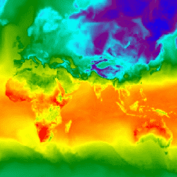
var dataset = ee.ImageCollection('NOAA/GFS0P25')
                  .filter(ee.Filter.date('2018-03-01', '2018-03-02'));
var temperatureAboveGround = dataset.select('temperature_2m_above_ground');
var visParams = {
  min: -40.0,
  max: 35.0,
  palette: ['blue', 'purple', 'cyan', 'green', 'yellow', 'red'],
};
Map.setCenter(71.72, 52.48, 3.0);
Map.addLayer(temperatureAboveGround, visParams, 'Temperature Above Ground');