- 데이터 세트 제공
- 2011-01-01T00:00:00Z–2025-12-17T18:00:00Z
- 데이터 세트 제공업체
- NOAA/NWS
- 케이던스
- 1시간
- 태그
설명
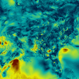
실시간 중간 규모 분석(RTMA)은 지표면 근처의 기상 조건에 대한 높은 공간 및 시간 해상도 분석입니다. 이 데이터 세트에는 미국 본토의 시간별 분석이 2.5km 간격으로 포함되어 있습니다.
대역
픽셀 크기
2,500미터
대역
| 이름 | 단위 | 최소 | 최대 | 픽셀 크기 | 설명 |
|---|---|---|---|---|---|
HGT |
m | -81* | 4226* | 미터 | 지형 고도 모델링 |
PRES |
Pa | 60848* | 105183* | 미터 | 압력 |
TMP |
°C | -43.2* | 43.73* | 미터 | 온도 |
DPT |
°C | -81.41* | 30.92* | 미터 | 이슬점 온도 |
UGRD |
m/s | -32.93* | 34.04* | 미터 | 풍속의 U 구성요소 |
VGRD |
m/s | -28.44* | 39.21* | 미터 | 풍속의 V 구성요소 |
SPFH |
질량 분율 | 0* | 0.02* | 미터 | 비습 |
WDIR |
deg | 0* | 360* | 미터 | 풍향(불어오는 방향) |
WIND |
m/s | 0* | 42.46* | 미터 | 풍속 |
GUST |
m/s | 0* | 58.02* | 미터 | 풍속(돌풍) |
VIS |
m | 0* | 20,000* | 미터 | 공개 상태 |
TCDC |
% | 0* | 100* | 미터 | 총 운량 |
ACPC01 |
kg/m^2 | 0* | 1* | 미터 | 총 강수량 |
이용약관
이용약관
NOAA 데이터, 정보, 제품은 제공 방법에 관계없이 저작권이 적용되지 않으며 누구나 제한 없이 후속 사용할 수 있습니다. 입수한 후에는 법적으로 허용되는 모든 용도로 자유롭게 사용할 수 있습니다. 위의 데이터는 공개 도메인에 속하며 사용 및 배포에 제한 없이 제공됩니다. 자세한 내용은 NWS 면책 조항 사이트를 참고하세요.
Earth Engine으로 탐색
코드 편집기(JavaScript)
var dataset = ee.ImageCollection('NOAA/NWS/RTMA')
                  .filter(ee.Filter.date('2018-03-01', '2018-03-02'));
var windSpeed = dataset.select('WIND');
var windSpeedVis = {
  min: 0.0,
  max: 12.0,
  palette: ['001137', '01abab', 'e7eb05', '620500'],
};
Map.setCenter(-95.62, 39.91, 4);
Map.addLayer(windSpeed, windSpeedVis, 'Wind Speed');