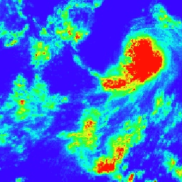
PERSIANN-CDR은 1983년 1월 1일부터 현재까지의 기간을 포함하는 일일 준전역 강수량 제품입니다. 데이터는 분기별로 생성되며 일반적으로 3개월의 지연이 있습니다. 이 제품은 ISCCP B1 IR 데이터를 GPCP 버전 2.2와 병합하여 파생된 격자 위성 (GridSat-B1) IR 데이터를 사용하여 캘리포니아 대학교 어바인 캠퍼스 (UC-IRVINE/CHRS)의 수문기상학 및 원격 감지 센터에서 개발했습니다.
이 데이터 세트를 소스로 사용하는 경우 다음을 인용하세요. Sorooshian, Soroosh; Hsu, Kuolin; Braithwaite, Dan; Ashouri, Hamed; and NOAA CDR Program(2014): NOAA Climate Data Record (CDR) of Precipitation Estimation from Remotely Sensed Information using Artificial Neural Networks(PERSIANN-CDR), Version 1 Revision 1. [사용된 하위 집합을 나타냅니다.] NOAA
National Centers for Environmental Information. doi:
doi:10.7289/V51V5BWQ
[액세스 날짜].
이 데이터 세트를 사용하는 출판물은 다음 학술지 논문도 인용해야 합니다. Ashouri H., K. Hsu, S. Sorooshian, D. K. Braithwaite,
K. R. Knapp, L. D. Cecil, B. R. 넬슨, O. P. Prat, 2015: PERSIANN-CDR:
Daily Precipitation Climate Data Record from Multi-Satellite Observations
for Hydrological and Climate Studies(수문학 및 기후 연구를 위한 다중 위성 관측의 일일 강수량 기후 데이터 기록). 황소 Amer. Meteor Soc.,
doi:10.1175/BAMS-D-13-00068.1.
PERSIANN-CDR은 1983년 1월 1일부터 현재까지의 기간을 포괄하는 일일 준전역 강수량 제품입니다. 데이터는 분기별로 생성되며 일반적으로 3개월의 지연이 있습니다. 이 제품은 캘리포니아 대학교 어바인 캠퍼스 (UC-IRVINE/CHRS)의 수문기상학 및 원격 감지 센터에서 격자형 위성 (GridSat-B1)을 사용하여 개발했습니다.
[null,null,[],[[["\u003cp\u003ePERSIANN-CDR provides daily, quasi-global precipitation data from 1983 to the present, produced by UC Irvine using satellite data.\u003c/p\u003e\n"],["\u003cp\u003eThe data is available at a 27.83 km resolution and represents estimated daily precipitation in millimeters.\u003c/p\u003e\n"],["\u003cp\u003ePERSIANN-CDR is a Climate Data Record (CDR) and is freely available for use with no restrictions.\u003c/p\u003e\n"],["\u003cp\u003eThe dataset is updated quarterly with a typical lag of three months.\u003c/p\u003e\n"],["\u003cp\u003eIt is accessible through Google Earth Engine and can be explored using provided code snippets.\u003c/p\u003e\n"]]],["The NOAA PERSIANN-CDR dataset provides daily, quasi-global precipitation data from 1983-01-01 to 2024-03-31, updated quarterly. This product, created by UC-IRVINE/CHRS, uses Gridded Satellite IR data and GPCP version 2.2. Data is available via the NOAA NCDC, and Earth Engine, as an ImageCollection, using 'precipitation' data, with a pixel size of 27830 meters. Users are encouraged to cite provided publications and DOIs when using this freely available dataset.\n"],null,["# PERSIANN-CDR: Precipitation Estimation From Remotely Sensed Information Using Artificial Neural Networks-Climate Data Record\n\nDataset Availability\n: 1983-01-01T00:00:00Z--2024-09-30T00:00:00Z\n\nDataset Provider\n:\n\n\n [NOAA NCDC](https://doi.org/10.7289/V51V5BWQ)\n\nCadence\n: 1 Day\n\nTags\n:\n [cdr](/earth-engine/datasets/tags/cdr) [climate](/earth-engine/datasets/tags/climate) [geophysical](/earth-engine/datasets/tags/geophysical) [noaa](/earth-engine/datasets/tags/noaa) [precipitation](/earth-engine/datasets/tags/precipitation) [weather](/earth-engine/datasets/tags/weather) \n ncdc \npersiann \n\n#### Description\n\nPERSIANN-CDR is a daily quasi-global precipitation product\nthat spans the period from 1983-01-01 to present. The data is\nproduced quarterly, with a typical lag of three months. The product\nis developed by the Center for Hydrometeorology and Remote Sensing\nat the University of California, Irvine (UC-IRVINE/CHRS) using\nGridded Satellite (GridSat-B1) IR data that are derived from merging\nISCCP B1 IR data, along with GPCP version 2.2.\n\n### Bands\n\n\n**Pixel Size**\n\n27830 meters\n\n**Bands**\n\n| Name | Units | Min | Max | Pixel Size | Description |\n|-----------------|-------|-----|----------|------------|-------------------------------|\n| `precipitation` | mm | 0\\* | 718.62\\* | meters | Estimated daily precipitation |\n\n\\* estimated min or max value\n\n### Terms of Use\n\n**Terms of Use**\n\nCDR data sets are nonproprietary, publicly available,\nand no restrictions are placed upon their use. For additional information,\nsee the [Fair Use of NOAA's CDR Data Sets, Algorithms and Documentation](https://www.ncdc.noaa.gov/sites/default/files/cdr-documentation/UseAgreement_0.pdf)\ndocument.\n\n### Citations\n\nCitations:\n\n- Cite this dataset when used as a source: Sorooshian, Soroosh;\n Hsu, Kuolin; Braithwaite, Dan; Ashouri, Hamed; and NOAA CDR Program\n (2014): NOAA Climate Data Record (CDR) of Precipitation Estimation\n from Remotely Sensed Information using Artificial Neural Networks\n (PERSIANN-CDR), Version 1 Revision 1. \\[indicate subset used\\]. NOAA\n National Centers for Environmental Information. doi:\n [doi:10.7289/V51V5BWQ](https://doi.org/10.7289/V51V5BWQ)\n \\[access date\\].\n- Publications using this dataset should also cite the following\n journal article: Ashouri H., K. Hsu, S. Sorooshian, D. K. Braithwaite,\n K. R. Knapp, L. D. Cecil, B. R. Nelson, and O. P. Prat, 2015: PERSIANN-CDR:\n Daily Precipitation Climate Data Record from Multi-Satellite Observations\n for Hydrological and Climate Studies. Bull. Amer. Meteor. Soc.,\n [doi:10.1175/BAMS-D-13-00068.1](https://doi.org/10.1175/BAMS-D-13-00068.1).\n\n### DOIs\n\n- \u003chttps://doi.org/10.1175/BAMS-D-13-00068.1\u003e\n- \u003chttps://doi.org/10.7289/V51V5BWQ\u003e\n\n### Explore with Earth Engine\n\n| **Important:** Earth Engine is a platform for petabyte-scale scientific analysis and visualization of geospatial datasets, both for public benefit and for business and government users. Earth Engine is free to use for research, education, and nonprofit use. To get started, please [register for Earth Engine access.](https://console.cloud.google.com/earth-engine)\n\n### Code Editor (JavaScript)\n\n```javascript\nvar dataset = ee.ImageCollection('NOAA/PERSIANN-CDR')\n .filter(ee.Filter.date('2017-05-01', '2017-05-02'));\nvar precipitation = dataset.select('precipitation');\nvar precipitationVis = {\n min: 0.0,\n max: 50.0,\n palette: ['3907ff', '03fff3', '28ff25', 'fbff09', 'ff1105'],\n};\nMap.setCenter(113.03, 3.34, 3);\nMap.addLayer(precipitation, precipitationVis, 'Precipitation');\n```\n[Open in Code Editor](https://code.earthengine.google.com/?scriptPath=Examples:Datasets/NOAA/NOAA_PERSIANN-CDR) \n[PERSIANN-CDR: Precipitation Estimation From Remotely Sensed Information Using Artificial Neural Networks-Climate Data Record](/earth-engine/datasets/catalog/NOAA_PERSIANN-CDR) \nPERSIANN-CDR is a daily quasi-global precipitation product that spans the period from 1983-01-01 to present. The data is produced quarterly, with a typical lag of three months. The product is developed by the Center for Hydrometeorology and Remote Sensing at the University of California, Irvine (UC-IRVINE/CHRS) using Gridded Satellite (GridSat-B1) ... \nNOAA/PERSIANN-CDR, cdr,climate,geophysical,noaa,precipitation,weather \n1983-01-01T00:00:00Z/2024-09-30T00:00:00Z \n-60 -180 60 180 \nGoogle Earth Engine \nhttps://developers.google.com/earth-engine/datasets\n\n- [https://doi.org/10.7289/V51V5BWQ](https://doi.org/https://doi.org/10.7289/V51V5BWQ)\n- [https://doi.org/10.7289/V51V5BWQ](https://doi.org/https://developers.google.com/earth-engine/datasets/catalog/NOAA_PERSIANN-CDR)"]]