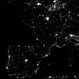
Monthly average radiance composite images using nighttime data from the
Visible Infrared Imaging Radiometer Suite (VIIRS) Day/Night Band (DNB).
As these data are composited monthly, there are many areas of the globe
where it is impossible to get good quality data coverage for that month.
This can be due to cloud cover, especially in the tropical regions, or due
to solar illumination, as happens toward the poles in their respective
summer months. Therefore it is recommended that users of these data utilize
the 'cf_cvg' band and not assume a value of zero in the average radiance
image means that no lights were observed.
Cloud cover is determined using the VIIRS Cloud
Mask product (VCM). In addition, data near the edges of the swath are not
included in the composites (aggregation zones 29-32). Version 1 has NOT
been filtered to screen out lights from aurora, fires, boats, and other
temporal lights. This separation is under development and will be included
in a later version of this time series. Also in development is a method to
separate lights from background (non-light) values.
This product is an alternative configuration of the VIIRS DNB using a
procedure to correct for stray light. The correction procedure extends
visible areas closer to the poles and improves dynamic range. It should be
noted some artifacts are introduced due to the procedure used in twilight
regions; see
reference paper
for more details. This product excludes data
impacted by cloud cover.
Bands
Pixel Size 463.83 meters
Bands
Name
Units
Min
Max
Pixel Size
Description
avg_rad
nanoWatts/sr/cm^2
-1.5*
193565*
meters
Average DNB radiance values.
cf_cvg
0*
84*
meters
Cloud-free coverages; the total number of observations that
went into each pixel. This band can be used to identify areas with low
numbers of observations where the quality is reduced.
* estimated min or max value
Terms of Use
Terms of Use
Colorado School of Mines data, information, and products,
regardless of the method of delivery,
are not subject to copyright and carry no restrictions on their subsequent
use by the public. Once obtained, they may be put to any lawful use. The
forgoing data is in the public domain and is being provided without
restriction on use and distribution.
Monthly average radiance composite images using nighttime data from the Visible Infrared Imaging Radiometer Suite (VIIRS) Day/Night Band (DNB). As these data are composited monthly, there are many areas of the globe where it is impossible to get good quality data coverage for that month. This can be due to …
[null,null,[],[[["\u003cp\u003eThe dataset provides monthly average radiance composite images using nighttime data from the Visible Infrared Imaging Radiometer Suite (VIIRS) Day/Night Band (DNB).\u003c/p\u003e\n"],["\u003cp\u003eIt includes a stray light correction procedure that extends visible areas closer to the poles and improves dynamic range, but may introduce artifacts in twilight regions.\u003c/p\u003e\n"],["\u003cp\u003eUsers should utilize the 'cf_cvg' band to identify areas with potential low-quality data due to cloud cover or solar illumination.\u003c/p\u003e\n"],["\u003cp\u003eThe dataset has not been filtered to screen out lights from aurora, fires, boats, and other temporal lights, which will be addressed in a later version.\u003c/p\u003e\n"],["\u003cp\u003eThe data is provided by the Colorado School of Mines and is in the public domain, free for any lawful use without restriction.\u003c/p\u003e\n"]]],["The dataset provides monthly average radiance composite images from the VIIRS Day/Night Band (DNB), spanning January 1, 2014, to October 1, 2024. It utilizes nighttime data corrected for stray light and excludes cloud-covered areas. Users are advised to check the 'cf_cvg' band for data quality due to potential cloud cover or solar illumination issues. The data, provided by the Colorado School of Mines, is available without usage restrictions and can be accessed via Earth Engine using the provided snippet and code. The images contain the average DNB radiance values and cloud-free coverage.\n"],null,["# VIIRS Stray Light Corrected Nighttime Day/Night Band Composites Version 1\n\nDataset Availability\n: 2014-01-01T00:00:00Z--2025-03-01T00:00:00Z\n\nDataset Provider\n:\n\n\n [Earth Observation Group, Payne Institute for Public Policy, Colorado School of Mines](https://eogdata.mines.edu/products/vnl/#monthly)\n\nCadence\n: 1 Month\n\nTags\n:\n [dnb](/earth-engine/datasets/tags/dnb) [eog](/earth-engine/datasets/tags/eog) [lights](/earth-engine/datasets/tags/lights) [monthly](/earth-engine/datasets/tags/monthly) [nighttime](/earth-engine/datasets/tags/nighttime) [noaa](/earth-engine/datasets/tags/noaa) [population](/earth-engine/datasets/tags/population) [viirs](/earth-engine/datasets/tags/viirs) [visible](/earth-engine/datasets/tags/visible) \nstray-light \n\n#### Description\n\nMonthly average radiance composite images using nighttime data from the\nVisible Infrared Imaging Radiometer Suite (VIIRS) Day/Night Band (DNB).\n\nAs these data are composited monthly, there are many areas of the globe\nwhere it is impossible to get good quality data coverage for that month.\nThis can be due to cloud cover, especially in the tropical regions, or due\nto solar illumination, as happens toward the poles in their respective\nsummer months. Therefore it is recommended that users of these data utilize\nthe 'cf_cvg' band and not assume a value of zero in the average radiance\nimage means that no lights were observed.\n\nCloud cover is determined using the VIIRS Cloud\nMask product (VCM). In addition, data near the edges of the swath are not\nincluded in the composites (aggregation zones 29-32). Version 1 has NOT\nbeen filtered to screen out lights from aurora, fires, boats, and other\ntemporal lights. This separation is under development and will be included\nin a later version of this time series. Also in development is a method to\nseparate lights from background (non-light) values.\n\nThis product is an alternative configuration of the VIIRS DNB using a\nprocedure to correct for stray light. The correction procedure extends\nvisible areas closer to the poles and improves dynamic range. It should be\nnoted some artifacts are introduced due to the procedure used in twilight\nregions; see\n[reference paper](https://spie.org/Publications/Proceedings/Paper/10.1117/12.2023107)\nfor more details. This product excludes data\nimpacted by cloud cover.\n\n### Bands\n\n\n**Pixel Size**\n\n463.83 meters\n\n**Bands**\n\n| Name | Units | Min | Max | Pixel Size | Description |\n|-----------|--------------------|--------|----------|------------|------------------------------------------------------------------------------------------------------------------------------------------------------------------------------------------|\n| `avg_rad` | nanoWatts/sr/cm\\^2 | -1.5\\* | 193565\\* | meters | Average DNB radiance values. |\n| `cf_cvg` | | 0\\* | 84\\* | meters | Cloud-free coverages; the total number of observations that went into each pixel. This band can be used to identify areas with low numbers of observations where the quality is reduced. |\n\n\\* estimated min or max value\n\n### Terms of Use\n\n**Terms of Use**\n\nColorado School of Mines data, information, and products,\nregardless of the method of delivery,\nare not subject to copyright and carry no restrictions on their subsequent\nuse by the public. Once obtained, they may be put to any lawful use. The\nforgoing data is in the public domain and is being provided without\nrestriction on use and distribution.\n\n### Explore with Earth Engine\n\n| **Important:** Earth Engine is a platform for petabyte-scale scientific analysis and visualization of geospatial datasets, both for public benefit and for business and government users. Earth Engine is free to use for research, education, and nonprofit use. To get started, please [register for Earth Engine access.](https://console.cloud.google.com/earth-engine)\n\n### Code Editor (JavaScript)\n\n```javascript\nvar dataset = ee.ImageCollection('NOAA/VIIRS/DNB/MONTHLY_V1/VCMSLCFG')\n .filter(ee.Filter.date('2017-05-01', '2017-05-31'));\nvar nighttime = dataset.select('avg_rad');\nvar nighttimeVis = {min: 0.0, max: 60.0};\nMap.setCenter(-77.1056, 38.8904, 8);\nMap.addLayer(nighttime, nighttimeVis, 'Nighttime');\n```\n[Open in Code Editor](https://code.earthengine.google.com/?scriptPath=Examples:Datasets/NOAA/NOAA_VIIRS_DNB_MONTHLY_V1_VCMSLCFG) \n[VIIRS Stray Light Corrected Nighttime Day/Night Band Composites Version 1](/earth-engine/datasets/catalog/NOAA_VIIRS_DNB_MONTHLY_V1_VCMSLCFG) \nMonthly average radiance composite images using nighttime data from the Visible Infrared Imaging Radiometer Suite (VIIRS) Day/Night Band (DNB). As these data are composited monthly, there are many areas of the globe where it is impossible to get good quality data coverage for that month. This can be due to ... \nNOAA/VIIRS/DNB/MONTHLY_V1/VCMSLCFG, dnb,eog,lights,monthly,nighttime,noaa,population,viirs,visible \n2014-01-01T00:00:00Z/2025-03-01T00:00:00Z \n-65 -180 75 180 \nGoogle Earth Engine \nhttps://developers.google.com/earth-engine/datasets\n\n- [](https://doi.org/https://eogdata.mines.edu/products/vnl/#monthly)\n- [](https://doi.org/https://developers.google.com/earth-engine/datasets/catalog/NOAA_VIIRS_DNB_MONTHLY_V1_VCMSLCFG)"]]