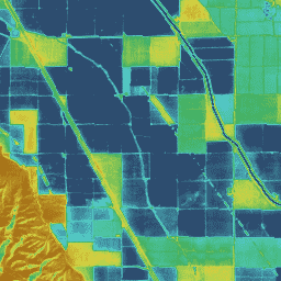
DisALEXI는 최근 OpenET 프레임워크의 일부로 Google Earth Engine으로 포팅되었으며 기준 ALEXI/DisALEXI 모델 구조는 Anderson et al. (2012, 2018)에 설명되어 있습니다. ALEXI 증발산량 (ET) 모델은 특히 정지궤도 또는 중간 해상도 극궤도 플랫폼에서 얻은 시간 차분 지표면 온도 (LST) 측정을 사용하여 지역 ET 지도를 생성합니다. 그런 다음 DisALEXI는 Landsat 데이터 (30m, 2주 간격)를 사용하여 지역 ALEXI ET를 더 세부적인 규모로 세분화하여 개별 농장 필드와 기타 지형지물을 해결합니다.
추가 정보
Anderson, M., Gao, F., Knipper, K., Hain, C., Dulaney, W., Baldocchi, D .,
Eichelmann, E., Hemes, K., Yang, Y., Medellin-Azuara, J. and Kustas, W.,
2018년. 원격 감지를 사용한 캘리포니아 델타의 토지 및 물 사용 변화에 대한 필드 규모 평가 Remote Sensing, 10(6), p.889.
doi:10.3390/rs10060889
Anderson, M.C., Norman, J.M., Mecikalski, J.R., Otkin, J.A. and Kustas,
W.P., 2007. 열 원격 감지를 기반으로 한 미국 대륙의 증산량 및 수분 스트레스에 관한 기후학적 연구: 1. 모델 공식화 Journal of Geophysical Research:
Atmospheres, 112(D10).
doi:10.1029/2006JD007506
대기권-지표 교환 역산 / 대기권-지표 교환 역산의 분해 (ALEXI/DisALEXI) DisALEXI는 최근 OpenET 프레임워크의 일부로 Google Earth Engine으로 포팅되었으며 기준 ALEXI/DisALEXI 모델 구조는 Anderson 외(2012, 2018)에 의해 설명됩니다. ALEXI 증발산량 (ET) 모델은 특히 시간 차이 지표면 …
[null,null,[],[[["\u003cp\u003eThe OpenET DisALEXI dataset provides monthly evapotranspiration (ET) data for the contiguous United States (CONUS) at a 30-meter resolution, derived from Landsat and GRIDMET data.\u003c/p\u003e\n"],["\u003cp\u003eDisALEXI, part of the OpenET framework, uses a model based on land surface temperature changes to estimate ET and is further disaggregated using Landsat for finer-scale detail.\u003c/p\u003e\n"],["\u003cp\u003eData is available from January 2008 to December 2023 and is provided by OpenET, Inc.under a CC-BY-4.0 license.\u003c/p\u003e\n"],["\u003cp\u003eThe dataset includes two bands: 'et' representing the DisALEXI ET value in millimeters and 'count' indicating the number of cloud-free values used in the calculation.\u003c/p\u003e\n"],["\u003cp\u003eUsers can explore and analyze this dataset within Google Earth Engine for research, education, and non-profit purposes.\u003c/p\u003e\n"]]],["The OpenET DisALEXI dataset, available from 2001-01-01 to 2023-12-01, provides monthly evapotranspiration (ET) data at a 30-meter resolution. It uses the ALEXI/DisALEXI model, which combines land surface temperature data with Landsat data to estimate ET, including a band with the 'et' value and a 'count' of cloud-free observations. The data can be accessed via Earth Engine using a provided code snippet and is licenced with a CC-BY-4.0 use license.\n"],null,["# OpenET DisALEXI Monthly Evapotranspiration v2.0\n\nDataset Availability\n: 2001-01-01T00:00:00Z--2024-12-01T00:00:00Z\n\nDataset Provider\n:\n\n\n [OpenET, Inc.](https://openetdata.org/)\n\nCadence\n: 1 Month\n\nTags\n:\n[evapotranspiration](/earth-engine/datasets/tags/evapotranspiration) [gridmet-derived](/earth-engine/datasets/tags/gridmet-derived) [landsat-derived](/earth-engine/datasets/tags/landsat-derived) [monthly](/earth-engine/datasets/tags/monthly) [openet](/earth-engine/datasets/tags/openet) [water](/earth-engine/datasets/tags/water) [water-vapor](/earth-engine/datasets/tags/water-vapor) \n\n#### Description\n\nAtmosphere-Land Exchange Inverse / Disaggregation of the Atmosphere-Land\nExchange Inverse (ALEXI/DisALEXI)\n\nDisALEXI was recently ported to Google Earth Engine as part of the OpenET\nframework and the baseline ALEXI/DisALEXI model structure is described by\nAnderson et al. (2012, 2018). The ALEXI evapotranspiration (ET) model\nspecifically uses time differential land surface temperature (LST)\nmeasurements from geostationary or moderate resolution polar orbiting\nplatforms to generate regional ET maps. DisALEXI then disaggregates the\nregional ALEXI ET to finer scales using Landsat data (30 m; biweekly) to\nresolve individual farm fields and other landscape features.\n[Additional information](https://openetdata.org/methodologies/)\n\n### Bands\n\n\n**Pixel Size**\n\n30 meters\n\n**Bands**\n\n| Name | Units | Pixel Size | Description |\n|---------|-------|------------|-----------------------------|\n| `et` | mm | meters | DisALEXI ET value |\n| `count` | count | meters | Number of cloud free values |\n\n### Image Properties\n\n**Image Properties**\n\n| Name | Type | Description |\n|-----------------------|--------|----------------------------------------------------------------------------------------------|\n| build_date | STRING | Date assets were built |\n| cloud_cover_max | DOUBLE | Maximum CLOUD_COVER_LAND percent value for Landsat images included in interpolation |\n| collections | STRING | List of Landsat collections for Landsat images included in the interpolation |\n| core_version | STRING | OpenET core library version |\n| end_date | STRING | End date of month |\n| et_reference_band | STRING | Band in et_reference_source that contains the daily reference ET data |\n| et_reference_resample | STRING | Spatial interpolation mode to resample daily reference ET data |\n| et_reference_source | STRING | Collection ID for the daily reference ET data |\n| interp_days | DOUBLE | Maximum number of days before and after each image date to include in interpolation |\n| interp_method | STRING | Method used to interpolate between Landsat model estimates |\n| interp_source_count | DOUBLE | Number of available images in the interpolation source image collection for the target month |\n| mgrs_tile | STRING | MGRS grid zone ID |\n| model_name | STRING | OpenET model name |\n| model_version | STRING | OpenET model version |\n| scale_factor_count | DOUBLE | Scaling factor that should be applied to the count band |\n| scale_factor_et | DOUBLE | Scaling factor that should be applied to the et band |\n| start_date | STRING | Start date of month |\n\n### Terms of Use\n\n**Terms of Use**\n\n[CC-BY-4.0](https://spdx.org/licenses/CC-BY-4.0.html)\n\n### Citations\n\nCitations:\n\n- Anderson, M., Gao, F., Knipper, K., Hain, C., Dulaney, W., Baldocchi, D .,\n Eichelmann, E., Hemes, K., Yang, Y., Medellin-Azuara, J. and Kustas, W.,\n 2018. Field-scale assessment of land and water use change over the\n California Delta using remote sensing. Remote Sensing, 10(6), p.889.\n [doi:10.3390/rs10060889](https://doi.org/10.3390/rs10060889)\n- Anderson, M.C., Norman, J.M., Mecikalski, J.R., Otkin, J.A. and Kustas,\n W.P., 2007. A climatological study of evapotranspiration and moisture\n stress across the continental United States based on thermal remote\n sensing: 1. Model formulation. Journal of Geophysical Research:\n Atmospheres, 112(D10).\n [doi:10.1029/2006JD007506](https://doi.org/10.1029/2006JD007506)\n\n### DOIs\n\n- \u003chttps://doi.org/10.3390/rs10060889\u003e\n\n### Explore with Earth Engine\n\n| **Important:** Earth Engine is a platform for petabyte-scale scientific analysis and visualization of geospatial datasets, both for public benefit and for business and government users. Earth Engine is free to use for research, education, and nonprofit use. To get started, please [register for Earth Engine access.](https://console.cloud.google.com/earth-engine)\n\n### Code Editor (JavaScript)\n\n```javascript\nvar dataset = ee.ImageCollection('OpenET/DISALEXI/CONUS/GRIDMET/MONTHLY/v2_0')\n .filterDate('2020-01-01', '2021-01-01');\n\n// Compute the annual evapotranspiration (ET) as the sum of the monthly ET\n// images for the year.\nvar et = dataset.select('et').sum();\n\nvar visualization = {\n min: 0,\n max: 1400,\n palette: [\n '9e6212', 'ac7d1d', 'ba9829', 'c8b434', 'd6cf40', 'bed44b', '9fcb51',\n '80c256', '61b95c', '42b062', '45b677', '49bc8d', '4dc2a2', '51c8b8',\n '55cece', '4db4ba', '459aa7', '3d8094', '356681', '2d4c6e',\n ]\n};\n\nMap.setCenter(-100, 38, 5);\n\nMap.addLayer(et, visualization, 'OpenET DisALEXI Annual ET');\n```\n[Open in Code Editor](https://code.earthengine.google.com/?scriptPath=Examples:Datasets/OpenET/OpenET_DISALEXI_CONUS_GRIDMET_MONTHLY_v2_0) \n[OpenET DisALEXI Monthly Evapotranspiration v2.0](/earth-engine/datasets/catalog/OpenET_DISALEXI_CONUS_GRIDMET_MONTHLY_v2_0) \nAtmosphere-Land Exchange Inverse / Disaggregation of the Atmosphere-Land Exchange Inverse (ALEXI/DisALEXI) DisALEXI was recently ported to Google Earth Engine as part of the OpenET framework and the baseline ALEXI/DisALEXI model structure is described by Anderson et al. (2012, 2018). The ALEXI evapotranspiration (ET) model specifically uses time differential land surface ... \nOpenET/DISALEXI/CONUS/GRIDMET/MONTHLY/v2_0, evapotranspiration,gridmet-derived,landsat-derived,monthly,openet,water,water-vapor \n2001-01-01T00:00:00Z/2024-12-01T00:00:00Z \n25 -126 50 -66 \nGoogle Earth Engine \nhttps://developers.google.com/earth-engine/datasets\n\n- [https://doi.org/10.3390/rs10060889](https://doi.org/https://openetdata.org/)\n- [https://doi.org/10.3390/rs10060889](https://doi.org/https://developers.google.com/earth-engine/datasets/catalog/OpenET_DISALEXI_CONUS_GRIDMET_MONTHLY_v2_0)"]]