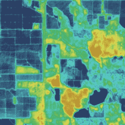
OpenET 데이터 세트에는 증발산 (ET) 과정을 통해 지표에서 대기로 이동하는 총 물의 양에 관한 위성 기반 데이터가 포함되어 있습니다. OpenET는 여러 위성 기반 모델의 ET 데이터를 제공하며 모델 앙상블에서 단일 '앙상블 값'도 계산합니다. 현재 OpenET 모델 앙상블에 포함된 모델은 ALEXI/DisALEXI, eeMETRIC, geeSEBAL, PT-JPL, SIMS, SSEBop입니다. OpenET 앙상블 ET 값은 중앙값 절대 편차 접근 방식을 사용하여 이상치를 필터링하고 제거한 후 앙상블의 평균으로 계산됩니다. 현재 모든 모델은 Landsat 위성 데이터를 사용하여 30m x 30m (픽셀당 0.22에이커)의 픽셀 크기로 ET 데이터를 생성합니다. 월별 ET 데이터 세트는 월별 총 ET에 관한 데이터를 밀리미터 단위의 물 깊이로 제공합니다.
Melton, F., Huntington, J., Grimm, R., Herring, J., Hall, M., Rollison, D.,
Erickson, T., Allen, R., Anderson, M., Fisher, J., Kilic, A., Senay, G.,
volk, J., Hain, C., Johnson, L., Ruhoff, A., Blankenau, P., 브롬리, M.,
Carrara, W., Daudert, B., Doherty, C., Dunkerly, C., Friedrichs, M., Guzman,
A., Halverson, G., 한센, J., Harding, J., Kang, Y., Ketchum, D., Minor,
B., Morton, C., Revelle, P., Ortega-Salazar, S., Ott, T., Ozdogon, M.,
Schull, M., Wang, T., Yang, Y., Anderson, R., 2021년. OpenET: 미국 서부의 물 관리에서 중요한 데이터 격차를 해소합니다.
Journal of the American Water Resources Association, 2021년 11월 2일
doi:10.1111/1752-1688.12956
[null,null,[],[[["\u003cp\u003eThe OpenET dataset provides monthly satellite-based evapotranspiration (ET) data for the Contiguous United States (CONUS) from 2008 to 2023.\u003c/p\u003e\n"],["\u003cp\u003eIt includes data from six different ET models (ALEXI/DisALEXI, eeMETRIC, geeSEBAL, PT-JPL, SIMS, and SSEBop) and calculates an ensemble ET value.\u003c/p\u003e\n"],["\u003cp\u003eThe dataset is available at a 30-meter spatial resolution and provides ET as an equivalent depth of water in millimeters.\u003c/p\u003e\n"],["\u003cp\u003eOpenET data is derived from Landsat satellite imagery and is available under a CC-BY-4.0 license.\u003c/p\u003e\n"],["\u003cp\u003eThe OpenET ensemble ET value represents the mean of the ensemble after filtering outliers using the median absolute deviation approach.\u003c/p\u003e\n"]]],[],null,["# OpenET Ensemble Monthly Evapotranspiration v2.0\n\nDataset Availability\n: 1999-10-01T00:00:00Z--2024-12-01T00:00:00Z\n\nDataset Provider\n:\n\n\n [OpenET, Inc.](https://openetdata.org/)\n\nCadence\n: 1 Month\n\nTags\n:\n[evapotranspiration](/earth-engine/datasets/tags/evapotranspiration) [gridmet-derived](/earth-engine/datasets/tags/gridmet-derived) [landsat-derived](/earth-engine/datasets/tags/landsat-derived) [monthly](/earth-engine/datasets/tags/monthly) [openet](/earth-engine/datasets/tags/openet) [water](/earth-engine/datasets/tags/water) [water-vapor](/earth-engine/datasets/tags/water-vapor) \n\n#### Description\n\nThe OpenET dataset includes satellite-based data on the total amount of\nwater that is transferred from the land surface to the atmosphere through\nthe process of evapotranspiration (ET). OpenET provides ET data from\nmultiple satellite-driven models, and also calculates a single \"ensemble\nvalue\" from the model ensemble. The models currently included in the OpenET\nmodel ensemble are ALEXI/DisALEXI, eeMETRIC, geeSEBAL, PT-JPL, SIMS, and\nSSEBop. The OpenET ensemble ET value is calculated as the mean of the\nensemble after filtering and removing outliers using the median absolute\ndeviation approach. All models currently use Landsat satellite data to\nproduce ET data at a pixel size of 30 meters by 30 meters (0.22 acres per\npixel). The monthly ET dataset provides data on total ET by month as an\nequivalent depth of water in millimeters.\n\n[Additional information](https://openetdata.org/methodologies/)\n\n### Bands\n\n\n**Pixel Size**\n\n30 meters\n\n**Bands**\n\n| Name | Units | Pixel Size | Description |\n|-------------------------|-------|------------|------------------------------------------------------------------------------------------------------------------------------------------------|---|---|---|---|---|---|---|---|---|---|---|---|---|---|---|---|---|---|---|---|---|---|---|---|---|---|---|---|---|---|---|---|---|---|---|---|---|---|---|---|---|---|---|---|---|---|---|---|---|---|---|---|---|---|---|---|---|---|---|---|---|---|---|---|---|---|---|---|---|---|---|---|---|---|---|---|---|---|---|---|---|---|---|---|---|---|---|---|---|---|---|---|---|---|---|---|\n| `et_ensemble_mad` | mm | meters | Ensemble ET value, computed as the mean of the ensemble after filtering outliers using the median absolute deviation (mad) |\n| `et_ensemble_mad_min` | mm | meters | The minimum value in the ensemble range, after filtering for outliers using the median absolute deviation (mad) |\n| `et_ensemble_mad_max` | mm | meters | The maximum value in the ensemble range, after filtering for outliers using the median absolute deviation (mad) |\n| `et_ensemble_mad_count` | | meters | The number of models used to compute the ensemble ET value, after filtering for outliers using the median absolute deviation (mad) |\n| `et_ensemble_mad_index` | | meters | Bitmask indicating which models were included in the ensemble ET value, after filtering for outliers using the median absolute deviation (mad) |\n| Bitmask for et_ensemble_mad_index - Bit 0: DisALEXI included in ensemble - 0: No - 1: Yes - Bit 1: EEMETRIC included in ensemble - 0: No - 1: Yes - Bit 2: GEESEBAL included in ensemble - 0: No - 1: Yes - Bit 3: PTJPL included in ensemble - 0: No - 1: Yes - Bit 4: SIMS included in ensemble - 0: No - 1: Yes - Bit 5: SSEBop included in ensemble - 0: No - 1: Yes ||||||||||||||||||||||||||||||||||||||||||||||||||||||||||||||||||||||||||||||||||||||||||||||||||||\n| `et_ensemble_sam` | mm | meters | The simple arithmetic mean (sam) of all six models in the OpenETmodel ensemble |\n\n### Image Properties\n\n**Image Properties**\n\n| Name | Type | Description |\n|--------------|--------|-----------------------------|\n| build_date | STRING | Date assets were built |\n| core_version | STRING | OpenET core library version |\n| end_date | STRING | End date of month |\n| mgrs_tile | STRING | MGRS grid zone ID |\n| start_date | STRING | Start date of month |\n\n### Terms of Use\n\n**Terms of Use**\n\n[CC-BY-4.0](https://spdx.org/licenses/CC-BY-4.0.html)\n\n### Citations\n\nCitations:\n\n- Melton, F., Huntington, J., Grimm, R., Herring, J., Hall, M., Rollison, D.,\n Erickson, T., Allen, R., Anderson, M., Fisher, J., Kilic, A., Senay, G.,\n volk, J., Hain, C., Johnson, L., Ruhoff, A., Blankenau, P., Bromley, M.,\n Carrara, W., Daudert, B., Doherty, C., Dunkerly, C., Friedrichs, M., Guzman,\n A., Halverson, G., Hansen, J., Harding, J., Kang, Y., Ketchum, D., Minor,\n B., Morton, C., Revelle, P., Ortega-Salazar, S., Ott, T., Ozdogon, M.,\n Schull, M., Wang, T., Yang, Y., Anderson, R., 2021. OpenET: Filling a\n Critical Data Gap in Water Management for the Western United States.\n Journal of the American Water Resources Association, 2021 Nov 2.\n [doi:10.1111/1752-1688.12956](https://doi.org/10.1111/1752-1688.12956)\n\n### DOIs\n\n- \u003chttps://doi.org/10.1111/1752-1688.12956\u003e\n\n### Explore with Earth Engine\n\n| **Important:** Earth Engine is a platform for petabyte-scale scientific analysis and visualization of geospatial datasets, both for public benefit and for business and government users. Earth Engine is free to use for research, education, and nonprofit use. To get started, please [register for Earth Engine access.](https://console.cloud.google.com/earth-engine)\n\n### Code Editor (JavaScript)\n\n```javascript\nvar dataset = ee.ImageCollection('OpenET/ENSEMBLE/CONUS/GRIDMET/MONTHLY/v2_0')\n .filterDate('2020-01-01', '2021-01-01');\n\n// Compute the annual evapotranspiration (ET) as the sum of the monthly ET\n// images for the year.\nvar et = dataset.select('et_ensemble_mad').sum();\n\nvar visualization = {\n min: 0,\n max: 1400,\n palette: [\n '9e6212', 'ac7d1d', 'ba9829', 'c8b434', 'd6cf40', 'bed44b', '9fcb51',\n '80c256', '61b95c', '42b062', '45b677', '49bc8d', '4dc2a2', '51c8b8',\n '55cece', '4db4ba', '459aa7', '3d8094', '356681', '2d4c6e',\n ]\n};\n\nMap.setCenter(-100, 38, 5);\n\nMap.addLayer(et, visualization, 'OpenET Ensemble Annual ET');\n```\n[Open in Code Editor](https://code.earthengine.google.com/?scriptPath=Examples:Datasets/OpenET/OpenET_ENSEMBLE_CONUS_GRIDMET_MONTHLY_v2_0) \n[OpenET Ensemble Monthly Evapotranspiration v2.0](/earth-engine/datasets/catalog/OpenET_ENSEMBLE_CONUS_GRIDMET_MONTHLY_v2_0) \nThe OpenET dataset includes satellite-based data on the total amount of water that is transferred from the land surface to the atmosphere through the process of evapotranspiration (ET). OpenET provides ET data from multiple satellite-driven models, and also calculates a single \"ensemble value\" from the model ensemble. The models currently ... \nOpenET/ENSEMBLE/CONUS/GRIDMET/MONTHLY/v2_0, evapotranspiration,gridmet-derived,landsat-derived,monthly,openet,water,water-vapor \n1999-10-01T00:00:00Z/2024-12-01T00:00:00Z \n25 -126 50 -66 \nGoogle Earth Engine \nhttps://developers.google.com/earth-engine/datasets\n\n- [https://doi.org/10.1111/1752-1688.12956](https://doi.org/https://openetdata.org/)\n- [https://doi.org/10.1111/1752-1688.12956](https://doi.org/https://developers.google.com/earth-engine/datasets/catalog/OpenET_ENSEMBLE_CONUS_GRIDMET_MONTHLY_v2_0)"]]