- 데이터 세트 사용 가능 기간
- 2001-01-01T00:00:00Z–2002-01-01T00:00:00Z
- 데이터 세트 제공업체
- EnvirometriX Ltd
- 태그
설명
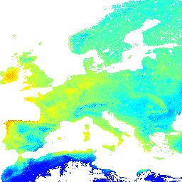
대역
픽셀 크기
1,000미터
대역
| 이름 | 단위 | 최소 | 최대 | 픽셀 크기 | 설명 |
|---|---|---|---|---|---|
jan |
분수 | 0* | 220* | 미터 | 1월 잠재 FAPAR 월별 |
feb |
분수 | 0* | 220* | 미터 | 2월 잠재적 FAPAR 월별 |
mar |
분수 | 0* | 220* | 미터 | 3월 잠재 FAPAR 월별 |
apr |
분수 | 0* | 220* | 미터 | 4월 잠재적 FAPAR 월별 |
may |
분수 | 0* | 220* | 미터 | May Potential FAPAR monthly(5월 잠재 FAPAR 월별) |
jun |
분수 | 0* | 220* | 미터 | 6월 잠재 FAPAR 월별 |
jul |
분수 | 0* | 220* | 미터 | 7월 잠재 FAPAR 월별 |
aug |
분수 | 0* | 220* | 미터 | 8월 잠재 FAPAR 월별 |
sep |
분수 | 0* | 220* | 미터 | 9월 잠재적 FAPAR 월별 |
oct |
분수 | 0* | 220* | 미터 | 10월 잠재 FAPAR 월별 |
nov |
분수 | 0* | 220* | 미터 | 11월 잠재 FAPAR 월별 |
dec |
분수 | 0* | 220* | 미터 | 12월 잠재적 FAPAR 월별 |
annual |
분수 | 0* | 220* | 미터 | 연간 잠재 FAPAR 월별 |
annualdiff |
분수 | 0* | 220* | 미터 | 연간 차이 잠재력 FAPAR 월별 |
이용약관
이용약관
라이선스를 대체하는 것이 아니라 사람이 읽을 수 있는 요약입니다.
다음과 같은 행위는 허용됩니다. 공유 - 어떤 매체나 형식으로든 자료를 복사하고 재배포할 수 있습니다. 변형 - 상업적 목적을 포함한 어떤 목적으로든 자료를 리믹스, 변형, 재사용할 수 있습니다.
이 라이선스는 무료 문화 작품에 허용됩니다. 라이선스 약관을 준수하는 한 라이선스 제공자는 이러한 자유를 취소할 수 없습니다.
다음 조건에 따라야 합니다. 저작자 표시 - 적절한 출처를 표시하고, 라이선스 링크를 제공하고, 변경사항이 있는 경우 이를 표시해야 합니다. 합리적인 방식으로 표시할 수 있지만 라이선스 제공자가 귀하 또는 귀하의 사용을 보증하는 것으로 보이는 방식으로는 표시할 수 없습니다.
동일 조건 - 자료를 리믹스, 변형 또는 기반으로 하는 경우 원본과 동일한 라이선스로 기여한 부분을 배포해야 합니다.
추가 제한 없음 - 라이선스에서 허용하는 행위를 다른 사람이 법적으로 제한하는 법적 조건이나 기술적 조치를 적용할 수 없습니다.
인용
Hengl T, Walsh MG, Sanderman J, Wheeler I, Harrison SP, Prentice IC. (2018) 잠재적 자연 식생의 전 세계 매핑: 토지 잠재력 추정을 위한 머신러닝 알고리즘 평가. PeerJ Preprints. 10.7287/peerj.preprints.26811v5
DOI
Earth Engine으로 탐색하기
코드 편집기(JavaScript)
var dataset = ee.Image('OpenLandMap/PNV/PNV_FAPAR_PROBA-V_D/v01');

var visualization = {
  bands: ['jan'],
  min: 0.0,
  max: 220.0,
  palette: ['0000ff', '00ffff', 'ffff00', 'ff0000']
};

Map.centerObject(dataset);

Map.addLayer(dataset, visualization, 'Potential FAPAR monthly');