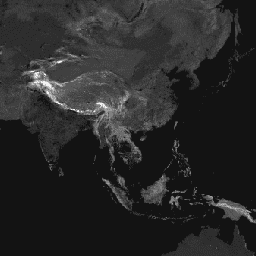
이 전역 마찰 표면은 명목상 2019년의 북위 85도와 남위 60도 사이의 모든 육지 픽셀에 대한 육상 이동 속도를 열거합니다. 또한 모터가 없는 교통수단만 사용하는 '도보 전용' 이동 속도도 포함됩니다.
이 지도는 MAP(옥스퍼드 대학교), Telethon Kids Institute(오스트레일리아 퍼스), Google, 트벤테 대학교(네덜란드)의 공동작업을 통해 제작되었습니다.
이 프로젝트는 Weiss et al 2018 (doi:10.1038/nature25181)에서 발표한 이전 작업을 기반으로 합니다. Weiss et al (2018)은 도로 (Open Street Map 및 Google 도로 데이터 세트의 최초 글로벌 규모 사용 포함), 철도, 강, 호수, 바다, 지형 조건 (경사 및 고도), 토지 피복 유형, 국경에 관한 데이터 세트를 활용했습니다. 이러한 데이터 세트에는 각 유형의 픽셀을 통과하는 데 걸리는 시간으로 표현된 이동 속도가 각각 할당되었습니다. 그런 다음 데이터 세트를 결합하여 '마찰 표면'을 생성했습니다. 이 지도는 각 픽셀에 해당 픽셀 내에서 발생하는 유형에 따라 명목상의 전체 이동 속도가 할당된 지도입니다. 현재 프로젝트의 경우 OSM 도로 데이터의 최근 개선사항을 통합하기 위해 업데이트된 마찰 표면이 생성되었습니다.
이 마찰 표면과 2015년 버전 (Weiss et al. 2018) 간의 차이가 반드시 인프라 (예: 새로운 도로 건설)의 변화를 나타내는 것은 아닙니다. 이러한 불일치는 데이터 품질 개선, 특히 OSM 도로 범위 업데이트와 관련이 있을 가능성이 훨씬 높습니다. 따라서 마찰 표면과 결과 이동 시간 지도 간의 비교는 신중하게 수행해야 하며 일반적으로 시간 경과에 따른 액세스 변화를 나타내는 것으로 해석해서는 안 됩니다.
이 지도는 이 할당 프로세스의 이동 속도를 나타내며, 1미터를 이동하는 데 필요한 시간(분)으로 표시됩니다. 이 데이터는 참조된 논문에 설명된 글로벌 의료 접근성 지도의 기본 데이터 세트를 구성합니다.
D.J. Weiss, A. Nelson, C.A. Vargas-Ruiz, K. Gligorić, S. Bavadekar,
E. Gabrilovich, A. Bertozzi-Villa, J. Rozier, H.S. Gibson, T. Shekel,
C. Kamath, A. Lieber, K. Schulman, Y. Shao, V. Qarkaxhija, A.K. Nandi,
S.H. Keddie, S. Rumisha, E. Cameron, K.E. Battle, S. Bhatt, P.W. Gething.
의료 시설까지의 이동 시간을 보여주는 전 세계 지도입니다. Nature Medicine (2020년).
[null,null,[],[[["\u003cp\u003eThis dataset provides a global friction surface, representing land-based travel speed for all land pixels between 85 degrees north and 60 degrees south for the year 2019.\u003c/p\u003e\n"],["\u003cp\u003eIt includes both overall travel speed and "walking-only" travel speed, using non-motorized means of transportation.\u003c/p\u003e\n"],["\u003cp\u003eThe friction surface was created by combining datasets for roads, railways, rivers, lakes, oceans, topographic conditions, landcover types, and national borders, assigning each a speed of travel.\u003c/p\u003e\n"],["\u003cp\u003eDeveloped through a collaboration between the Malaria Atlas Project (MAP), Telethon Kids Institute, Google, and the University of Twente.\u003c/p\u003e\n"],["\u003cp\u003eIt is important to note that differences between this friction surface and previous versions may be due to improved data quality rather than actual infrastructure changes.\u003c/p\u003e\n"]]],[],null,["# Global Friction Surface 2019\n\nDataset Availability\n: 2019-01-01T00:00:00Z--2020-01-01T00:00:00Z\n\nDataset Provider\n:\n\n\n [Malaria Atlas Project](https://malariaatlas.org/research-project/accessibility-to-cities/)\n\nTags\n:\n [accessibility](/earth-engine/datasets/tags/accessibility) [jrc](/earth-engine/datasets/tags/jrc) [map](/earth-engine/datasets/tags/map) [oxford](/earth-engine/datasets/tags/oxford) [population](/earth-engine/datasets/tags/population) [twente](/earth-engine/datasets/tags/twente) \nfriction \n\n#### Description\n\nThis global friction surface enumerates land-based travel speed for all land pixels between 85 degrees north and 60 degrees south for a nominal year 2019. It also includes \"walking-only\" travel speed, using non-motorized means of transportation only.\nThis map was produced through a collaboration between MAP (University of Oxford), Telethon Kids Institute (Perth, Australia), Google, and the University of Twente, Netherlands.\nThis project builds on previous work published by Weiss et al 2018 ([doi:10.1038/nature25181](https://doi.org/10.1038/nature25181)). Weiss et al (2018) utilised datasets for roads (comprising the first ever global-scale use of Open Street Map and Google roads datasets), railways, rivers, lakes, oceans, topographic conditions (slope and elevation), landcover types, and national borders. These datasets were each allocated a speed or speeds of travel in terms of time to cross each pixel of that type. The datasets were then combined to produce a \"friction surface\"; a map where every pixel is allocated a nominal overall speed of travel based on the types occurring within that pixel. For the current project, an updated friction surface was created to incorporate recent improvements within OSM roads data.\nDifferences between this friction surface and the 2015 version (Weiss et al. 2018) are not necessarily indicative of changes in infrastructure (e.g., new roads being built). Such discrepancies are far more likely to be associated with improved data quality, in particular updates made to OSM road coverage. As a result, comparisons between the friction surfaces and resulting travel time maps should be done cautiously and generally not interpreted as representing changes in access over time.\nThis map represents the travel speed from this allocation process, expressed in units of minutes required to travel one meter. It forms the underlying dataset behind the global healthcare accessibility map described in the referenced paper.\n\nSource dataset credits are as described in the accompanying paper.\n\n### Bands\n\n\n**Pixel Size**\n\n927.67 meters\n\n**Bands**\n\n| Name | Units | Min | Max | Pixel Size | Description |\n|-------------------------|---------------|----------|---------|------------|--------------------------------------------------------|\n| `friction` | minutes/meter | 0.000429 | 87.3075 | meters | Land-based travel speed. |\n| `friction_walking_only` | minutes/meter | 0.012 | 87.3075 | meters | Land-based travel speed using non-motorized transport. |\n\n### Terms of Use\n\n**Terms of Use**\n\nThis work is licensed under a [Creative Commons Attribution\n4.0 International License](https://creativecommons.org/licenses/by/4.0/).\n\n### Citations\n\nCitations:\n\n- D.J. Weiss, A. Nelson, C.A. Vargas-Ruiz, K. Gligorić, S. Bavadekar,\n E. Gabrilovich, A. Bertozzi-Villa, J. Rozier, H.S. Gibson, T. Shekel,\n C. Kamath, A. Lieber, K. Schulman, Y. Shao, V. Qarkaxhija, A.K. Nandi,\n S.H. Keddie, S. Rumisha, E. Cameron, K.E. Battle, S. Bhatt, P.W. Gething.\n Global maps of travel time to healthcare facilities. Nature Medicine (2020).\n\n### Explore with Earth Engine\n\n| **Important:** Earth Engine is a platform for petabyte-scale scientific analysis and visualization of geospatial datasets, both for public benefit and for business and government users. Earth Engine is free to use for research, education, and nonprofit use. To get started, please [register for Earth Engine access.](https://console.cloud.google.com/earth-engine)\n\n### Code Editor (JavaScript)\n\n```javascript\nvar dataset = ee.Image('Oxford/MAP/friction_surface_2019');\nvar landBasedTravelSpeed = dataset.select('friction');\nvar visParams = {\n min: 0.0022,\n max: 0.04,\n palette: [\n '313695', '4575b4', '74add1', 'abd9e9', 'e0f3f8', 'ffffbf', 'fee090',\n 'fdae61', 'f46d43', 'd73027', 'a50026'\n ],\n};\nMap.setCenter(43.55, 36.98, 4);\nMap.addLayer(landBasedTravelSpeed, visParams, 'Land-based travel speed');\n```\n[Open in Code Editor](https://code.earthengine.google.com/?scriptPath=Examples:Datasets/Oxford/Oxford_MAP_friction_surface_2019) \n[Global Friction Surface 2019](/earth-engine/datasets/catalog/Oxford_MAP_friction_surface_2019) \nThis global friction surface enumerates land-based travel speed for all land pixels between 85 degrees north and 60 degrees south for a nominal year 2019. It also includes \"walking-only\" travel speed, using non-motorized means of transportation only. This map was produced through a collaboration between MAP (University of Oxford), Telethon ... \nOxford/MAP/friction_surface_2019, accessibility,jrc,map,oxford,population,twente \n2019-01-01T00:00:00Z/2020-01-01T00:00:00Z \n-60 -180 85 180 \nGoogle Earth Engine \nhttps://developers.google.com/earth-engine/datasets\n\n- [](https://doi.org/https://malariaatlas.org/research-project/accessibility-to-cities/)\n- [](https://doi.org/https://developers.google.com/earth-engine/datasets/catalog/Oxford_MAP_friction_surface_2019)"]]