Page Summary
-
The dataset covers the period from 2001-01-01 to 2021-12-31 and is provided by Seoul National University (SNU).
-
It contains daily 5-km products generated by the Breathing Earth System Simulator (BESS) model, which couples various environmental processes.
-
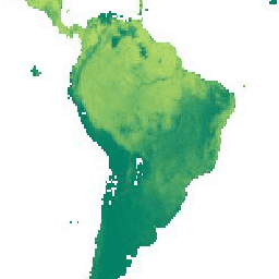
The dataset includes bands for surface downwelling photosynthetic radiative flux (PAR_Daily), diffuse photosynthetic radiative flux (PARdiff_Daily), and surface downwelling shortwave flux (RSDN_Daily), all in W/m^2 units with a pixel size of 5500 meters.
-
The terms of use for this dataset are specified as CC-BY-4.0.
-
The dataset can be explored and analyzed using the Google Earth Engine platform.
- Dataset Availability
- 2001-01-01T00:00:00Z–2021-12-31T00:00:00Z
- Dataset Producer
- Seoul National University (SNU)
- Cadence
- 1 Day
- Tags
Description
Breathing Earth System Simulator (BESS) is a simplified process-based model that couples atmosphere and canopy radiative transfers, canopy photosynthesis, transpiration, and energy balance. It couples an atmospheric radiative transfer model and artificial neural network with forcings from MODIS atmospheric products to generate 5-km daily products.
Publications:
- Ryu Youngryel, Chongya Jiang, Hideki Kobayashi, Matteo Detto, MODIS-derived global land products of shortwave radiation and diffuse and total photosynthetically active radiation at 5km resolution from 2000. Remote Sensing of Environment, Volume 204, 2018. doi:10.1016/j.rse.2017.09.021
Bands
Bands
Pixel size: 5500 meters (all bands)
| Name | Units | Pixel Size | Description |
|---|---|---|---|
PAR_Daily |
W/m^2 | 5500 meters | Surface downwelling photosynthetic radiative flux in air |
PARdiff_Daily |
W/m^2 | 5500 meters | Surface diffuse downwelling photosynthetic radiative flux in air |
RSDN_Daily |
W/m^2 | 5500 meters | Surface downwelling shortwave flux in air |
Terms of Use
Terms of Use
Explore with Earth Engine
Code Editor (JavaScript)
var dataset = ee.ImageCollection('SNU/ESL/BESS/Rad/v1');

var visParams = {
  bands: ['PAR_Daily'],
  min: 0,
  max: 70,
  palette: ['black', 'purple', 'blue', 'yellow', 'orange', 'red']
};

Map.setCenter(2.1, 24.9, 3);

Map.addLayer(
    dataset, visParams,
    'Surface downwelling photosynthetic radiative flux (W/m^2)');