- Доступность набора данных
- 2018-01-01T00:00:00Z–2019-01-01T00:00:00Z
- Поставщик наборов данных
- Бюро переписи населения США
- Теги
Описание
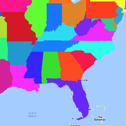
Набор данных TIGER Бюро переписи населения США содержит границы основных административно-территориальных единиц США по состоянию на 2018 год. Помимо пятидесяти штатов, Бюро переписи населения рассматривает округ Колумбия, Пуэрто-Рико и каждую из островных территорий (Американское Самоа, Содружество Северных Марианских Островов, Гуам и Американские Виргинские острова) в качестве статистических эквивалентов штатов для целей представления данных. Каждый объект представляет штат или эквивалент штата.
Полную техническую информацию о всех продуктах TIGER 2018 можно найти в технической документации TIGER .
Схема таблицы
Схема таблицы
| Имя | Тип | Описание |
|---|---|---|
| Аландские острова | ДВОЙНОЙ | Площадь земельного участка |
| ВОДА | ДВОЙНОЙ | Акватория |
| РАЗДЕЛЕНИЕ | НИТЬ | Код подразделения |
| ФУНКСТАТ | НИТЬ | Функциональное состояние |
| ГЕОИД | НИТЬ | Идентификатор штата; код штата FIPS |
| ИНТПЛАТ | НИТЬ | Широта внутренней точки |
| ИНПТЛОН | НИТЬ | Долгота внутренней точки |
| ЛСАД | НИТЬ | Описание юридической/статистической области для штата |
| МТФКК | НИТЬ | Код класса объектов MAF/TIGER (=G4000) |
| ИМЯ | НИТЬ | Название штата |
| ОБЛАСТЬ | НИТЬ | Код региона |
| STATEFP | НИТЬ | Государственный код FIPS |
| Стейтенс | НИТЬ | Государственный код GNIS |
| ШТУПС | НИТЬ | Аббревиатура штата Почтовая служба США |
Условия эксплуатации
Условия эксплуатации
Бюро переписи населения США предоставляет часть своих общедоступных данных в машиночитаемом формате через интерфейс прикладного программирования (API). Весь контент, документация, код и сопутствующие материалы, доступные через API, регулируются настоящими условиями .
Цитаты
Для создания любых отчетов, публикаций, новых наборов данных, производных продуктов или услуг на основе набора данных пользователи должны ссылаться на Бюро переписи населения США .
Исследуйте с Earth Engine
Редактор кода (JavaScript)
var dataset = ee.FeatureCollection('TIGER/2018/States');
var visParams = {
  palette: ['purple', 'blue', 'green', 'yellow', 'orange', 'red'],
  min: 500000000.0,
  max: 5e+11,
  opacity: 0.8,
};
var image = ee.Image().float().paint(dataset, 'ALAND');
Map.setCenter(-99.844, 37.649, 5);
Map.addLayer(image, visParams, 'TIGER/2018/States');
Map.addLayer(dataset, null, 'for Inspector', false);
Визуализировать как FeatureView
FeatureView — это ускоренное представление FeatureCollection , доступное только для просмотра. Подробнее см. в документации FeatureView .
Редактор кода (JavaScript)
var fvLayer = ui.Map.FeatureViewLayer('TIGER/2018/States_FeatureView');

var visParams = {
  opacity: 0.8,
  color: {
    property: 'ALAND',
    mode: 'linear',
    palette: ['purple', 'blue', 'green', 'yellow', 'orange', 'red'],
    min: 5e8,
    max: 5e11
  }
};

fvLayer.setVisParams(visParams);
fvLayer.setName('US census states');

Map.setCenter(-99.844, 37.649, 5);
Map.add(fvLayer);